Reyniès
|
Reyniès Reinièrs |
||
|---|---|---|

|
|
|
| region | Occitania | |
| Department | Tarn-et-Garonne | |
| Arrondissement | Montauban | |
| Canton | Tarn-Tescou-Quercy vert | |
| Community association | Grand Montauban | |
| Coordinates | 43 ° 55 ' N , 1 ° 24' E | |
| height | 75-204 m | |
| surface | 9.94 km 2 | |
| Residents | 860 (January 1, 2017) | |
| Population density | 87 inhabitants / km 2 | |
| Post Code | 82370 | |
| INSEE code | 82150 | |
| Website | http://www.coll82.com/reynies/ | |
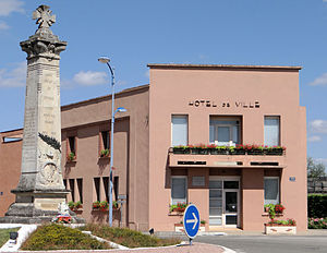
 Reyniès Town Hall (Mairie) |
||
Reyniès ( Occitan : Reinièrs ) is a French commune with 860 inhabitants (as of January 1, 2017) in the Tarn-et-Garonne department in the Occitanie region . It belongs to the arrondissement of Montauban and the canton of Tarn-Tescou-Quercy vert (until 2015: canton of Villebrumier ). The inhabitants are called Reynièsiens .
geography
Reyniès is located about nine kilometers south-southeast of Montauban on the Tarn , which also forms the southern municipal boundary. Reyniès is surrounded by the neighboring communities of Saint-Nauphary in the north and northeast, Villebrumier in the east, Nohic in the south and southeast, Orgueil in the south and Corbarieu in the west and northwest.
Population development
| year | 1962 | 1968 | 1975 | 1982 | 1990 | 1999 | 2006 | 2013 |
| Residents | 664 | 766 | 709 | 710 | 760 | 816 | 821 | 860 |
| Sources: Cassini and INSEE | ||||||||
Attractions
- Reyniès Castle, Monument historique since 1974
Web links
Commons : Reyniès - collection of images, videos and audio files

