
Neuhaus (Oste)
| coat of arms | Germany map | |
|---|---|---|
.svg)
|
Coordinates: 53 ° 48 ' N , 9 ° 2' E |
|
| Basic data | ||
| State : | Lower Saxony | |
| County : | Cuxhaven | |
| Joint municipality : | Land Hadeln | |
| Height : | 2 m above sea level NHN | |
| Area : | 9.86 km 2 | |
| Residents: | 1114 (Dec. 31, 2019) | |
| Population density : | 113 inhabitants per km 2 | |
| Postal code : | 21785 | |
| Area code : | 04752 | |
| License plate : | CUX | |
| Community key : | 03 3 52 039 | |
| Address of the stain management: |
Marktstrasse 21, 21762 Otterndorf |
|
| Website : | ||
| Mayor : | Georg Martens ( CDU ) | |
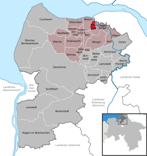
| Location of Neuhaus in the district of Cuxhaven | ||
 _in_CUX.svg) |
||


Neuhaus ( Low German Neehuus ) is at the Ostemündung situated spots in the land hadeln in Lower Saxony Cuxhaven .
geography
location
Neuhaus is located on the Oste near the Lower Elbe in the district of Cuxhaven and is part of the Land Hadeln municipality . Neuhaus is located south / east of Cuxhaven and north of Stade and Hamburg . Neighboring towns are Cadenberge in the east and south , Bülkau in the south / west and Belum in the west .
Waters
_2006_-Neuhaus-B%C3%BClkauer_Kanal-_by-RaBoe_02.jpg)
_1999-Neuhaus-B%C3%BClkauer_Kanal-by-RaBoe_01.jpg)

Baltic Sea
The Baltic sea is an oxbow lake of the Oste, it lies approximately 3 km from Neuhaus and was created when the Ostesperrwerk built in 1967 and the Oste was diverted. It is a fishing, surfing and swimming paradise with a water ski facility and a holiday park. The northern part of the lake, about 5 of 29 hectares, is a nature reserve and may not be entered.
Rivers and canals
- The Oste is the largest tributary of the Lower Elbe .
- The Neuhaus-Bülkauer Canal , also known as the Oppler Canal, is 12 km long and flows from the Balksee to Neuhaus (Oste) and from there into the Oste. It serves to drain the moors and the Balksee. The inhabitants of the low-lying districts of Bülkau , Oppeln and the Wingst owe it to the Oppl pastor Copper, who vigorously campaigned for the construction. The canal was built from 1852 to 1854 against the resistance of the higher-lying districts of Bülkau, as always it was about financing. Locks in Neuhaus soon prevented the backflow of salt water from the Elbe. This task was taken over by the eastern barrier during floods today .
- The floodplain , a former creek and until the construction of the Neuhaus-Bülkau Canal in the 19th century, is the only drainage of the hinterland in the Neuhaus (Oste) area, Bülkau to the Balksee with a catchment area of around 5000 hectares. It flows over a length of about 20 kilometers in many meanders through Oppeln, Bülkau, Kedingbruch to Neuhaus (Oste) and from there into the Oste.
history


First settlements
The settlement took place around 1000 AD on the Wurten around the Aue , Oste and Elbe , today's dike and Deichstrasse in Neuhaus were also part of it, as it consists of former Wurten . As early as 1100 Bülsdorf was called "Bulcenthorp" at that time, a western part of today's Neuhaus was mentioned in writing.
The first castle built in this area by the Bremen archbishops , the Schlickburg , ("Slikborch") was built at the confluence of the floodplain into the Oste. It was the seat of the archbishop's bailiff. This castle can be documented from 1371 to 1389, as Archbishop Albert , an incompetent regent, was always in need of money and pledged it to the cities of Bremen, Stade and Buxtehude before it was destroyed by the Kehdingern and Hadlers in order to gain the supremacy of the Bremen archbishops to prevent.
1400 to 1800
In 1404 the successor Archbishop Otto II built a new castle on the right bank of the river called Dat Nygehus (the new house); thus Neuhaus was first mentioned in a document. This castle was also destroyed by the neighbors in 1420. Even if the Nyehus was called a castle, it will have been, as is usual in the Elbe-Weser region, somewhat larger half-timbered buildings made of wood and brick with a palisade fence and a moat. The surrounding marshland formed a formal alliance in 1423. This alliance encompassed the whole of Kehdingen with the parishes of Bülkau, Oppeln, Belum and Bülsdorf, which only this time was designated as parish. Whether there was a church in the Bülsdorf parish cannot be proven, but it is difficult to imagine. It could be assumed that it was destroyed in the 15th century, as the parish was incorporated into Kehdingbruch around this time.
Archbishop Baldwin II built a building called “Castle” in 1435, although his predecessor had vowed to the angry marchers that he would never again build a bulwark as a threat to the Kehdinger. It was built on the floodplain in the middle of the village and whether it was more of a castle or a castle is a matter of dispute. In the 15th and 16th centuries it was often destroyed by the Hadlers, Wurstner and Kehdingers and not rebuilt in the 18th century. Today the former castle hill surrounded by the castle park with a large war memorial is still clearly visible.
Various combat operations have been handed down, the most important of which was the struggle for the so-called Land Bülkau , in which the parishes of Bülkau , Oppeln, Kehdingbruch and Belum wanted to realize their freedom from the Archbishop of Bremen, Christoph von Braunschweig, and to join the Hadelner Land. The Hadler sovereign, Duke Magnus of Saxony Lauenburg, supported these efforts. Despite his help, the archbishop managed to subdue the state of Bülkau . In 1516 contracts for the taxes of the rebellious parishes were concluded between the archbishop and that of Saxony Lauenburg, which, however, was not a punishment, but only a restoration of old contracts. However, the duke did not keep to the contract and plundered the archbishopric and Neuhaus castle. Although the castle was quickly rebuilt, since the archbishop always lacked money, he pawned individual parts of the archbishopric. Around 1540, Neuhaus Castle and all associated income were pledged to Johann von Münchhausen for 4,000 gold guilders. It was triggered by a special tax in 1544, but was occupied by the Protestant military leader Count Albrecht von Mansfeld in the Schmalkaldic War on June 9, 1547 without a fight. Almost a year later, the troops of the Archbishop of Bremen were able to easily recapture the castle.
The castle became the most important outpost of the Bremen bishops. In order to strengthen its power, it became the administrative seat of the Neuhaus office with its officials, first called Vogt, later called bailiff or Drost, and survived all the resistance of the Middle Ages. The boundaries of the area were in the north the North Sea, in the east the land Kehdingen and the parish east, in the south the Börde Lamstedt and in the west the land Hadeln. It included the parishes of Belum, Bülkau, Cadenberge, Geversdorf, Kehdingbruch, Oberndorf and Oppeln.
After the wars, which Neuhaus had seen first hand because of the Belumer Schanze, a strategically important and thus contested place very close to the mouth of the East, a quieter time began at the end of the 17th century.
Roads: In 1847, the Poststrasse from Stade to Ritzebüttel (today Cuxhaven) was completed, a forerunner of today's Bundesstrasse 73 . Before that time, the stagecoach had been out two or three times a week, now it drove daily. Around 1850 there was only a connection to Cadenberge and Otterndorf . The marsh streets were laborious to build and maintain. Around 1860 the road via Geversdorf to Freiburg / Elbe was added and around 1871 the well-developed road to Bülkau via Intzenbüttel and Kehdingbruch .
Rail: In 1872 there was a correspondence between the Neuhaus office and the Cuxhavener Eisenbahn-, Dampfschiff und Hafen AG , which wanted to build the line, with the Neuhausers participating in the costs of 100,000 thalers for the 1900-meter-longer line and the construction of the station. However, the shortest route between Cadenberge and Otterndorf was then built, 2.5 kilometers from Neuhaus. The line was opened for operation on November 11, 1881.
Since 1853, three times a week in the summer months, a steamship has brought travelers from Hamburg to Neuhaus, who then drove on to Hadler Land in a carriage.
In the 18th century Neuhaus became an administrative center. There was a post office since 1740. The port of Neuhausen became the most important trading hub in the region. It was the starting point for journeys, which at that time were less difficult by sea than by land.
The Meyers Conversations Lexicon from 1853 reads: “Hannoversches Amt, Landdrostei Stade, Duchy of Bremen , at the mouth of the Elbe, 12,500 inhabitants; Official place there, market town on the Oste, the place is nicely built and has a customs office, a tax reception, a port with 2 locks, the inhabitants do trade, shipbuilding, shipping, fishing, agriculture, red and white tannery, linen and wool weaving, urban trade in general 1520 inhabitants ”.
The dike
The emergence of large settlements was only possible through the dike in the Oste in 1478, whereby the existing Wurt was used, as well as through the construction of two locks in the floodplain. Now, not only farmers, Mieren and Kötnern settled here, but also boatmen and fishermen, merchants and craftsmen, and an urban society emerged in the Neuhaus area. Because the Oste was the fastest route to Bremervörde, the Archbishop's residence, in 1502 Neuhaus was expanded as a customs post.
_2006_-Zollhaus-_by-RaBoe_02.jpg)
At the end of the 16th century, the mayor was named mayor. From 1645 to 1681 the glory belonged to Neuhaus as a fiefdom of the Swedish crown under the von Königsmarck family.
Storm surges in 1717 and 1825
The worst storm surge on the North Sea coast also hit Neuhaus. During the Christmas flood of 1717, the Ostedeich broke in many places. The resulting flooding hit the area around the Mühle and Finkenhörne and destroyed 11 residential buildings with 5 outbuildings, 24 people drowned. Some of their bodies were not found until months later. The water was still in the church on December 30th. 557 horses, 2,254 horned cattle, 929 pigs and 1,413 sheep were killed in the Neuhaus district. It took a decade to normalize the situation in the fertile marshes.
During the severe storm surge on 3rd / 4th In February 1825 only one granary was destroyed and some houses were damaged. The Neuhausers helped the residents of the neighboring parishes. An aid association was founded, and the merchants Wolf and Ulex stood out in particular. They helped with 533 Reichstaler, 3 2/3 good groschen as well as with clothing and food.
Cholera in the 19th century
Neuhaus was hit twice by cholera, the first time in September 1834, 18 people died. Almost exactly 25 years later, from August 28 to September 20, 1859, another 17 people died, including the well-known Pastor Westphalen. There were no further cholera outbreaks because there was no more stagnant water in Neuhaus after the Neuhaus Bülkau Canal was built. Between the Amtshof and the Poststraße, the main artery of Neuhaus at that time, there was a dirty ditch called Poggenaue, which served as the basis for the later canal. This canal brought another flow of traffic into the office, on which peat, potatoes and other products from the surrounding area were transported for the next few decades. The main purpose of the canal, however, was to drain the Balksee and the moors in Opole and Bülkau.
Population development
The largest settlement Neuhaus was counted in 1858 with 266 houses and 1904 inhabitants. In 1821 there were only 237 houses with 1541 inhabitants. In 1885, with 290 houses, most of them were counted, but only 1738 inhabitants.
| year | 1987 | 1992 | 1997 | 2002 | 2007 | 2008 | 2009 | 2010 | 2011 |
|---|---|---|---|---|---|---|---|---|---|
| Residents | 1314 | 1356 | 1291 | 1285 | 1212 | 1186 | 1153 | 1148 | 1150 |
(as of December 31st)
Religions

_2006_-Emmauskirche-_by-RaBoe_02.jpg)
reformation
The Reformation arrived in the area early. When Neuhaus still belonged to the parish of Geversdorf , the vicars elected by the parish preached Protestant there, but finally the pastor Arend Schmidt, appointed by the cathedral provost , preached the new teachings until his death in 1562. The archbishops in Bremen became Protestant in 1567.
The first chapel
Ecclesiastically Neuhaus belonged to Geversdorf. In 1621 the archbishop approved the construction of a chapel and gave it the rectory. The preacher paid by the congregation taught the youth during the week. The Geversdorfer were still responsible for baptisms and funerals.
After 1660, the Neuhäuser tried again to separate from Geversdorf, as the population of Neuhaus and Geversdorf was the same, the way to the church official acts was long and the Neuhäuser had a schoolhouse and schoolmaster. Thanks to the help of Cord Christoph von Königsmarck, a son of Hans Christoph von Königsmarck , the Swedish government in Stade, according to a report by the University of Jena , made Neuhaus a parish in 1667. Count Königsmarck gave the community in 1550 Reichstaler in capitals and lands for the maintenance of the pastor, also had a big bell poured, his wife donated the baptismal font.
Emmaus Church
The baroque Emmaus Church made of bricks , a rectangular hall building , spanned with a mansard roof , was inaugurated in 1729. The entrance hall consists of the remains of the chapel from 1621. The roof turret came in 1729. The walls of the nave are divided into rectangular fields with arched windows.
Inside is a wooden, plastered barrel vault . Circular galleries on all sides . To the east is the pulpit altar wall , crowned with a crucifix . Statuettes of Christ and the Evangelists on the pulpit basket and on the soundboard .
Large parts of the inventory were taken over, such as the baptismal font from 1668 with the foot from 1730, the old altarpiece, the richly decorated sacrament chalices, one from 1644, two altar candlesticks from 1728 and the epitaphs of the first two pastors from 1667. The ones in Germany only twice Very fine plaster carvings in a similar form date from the beginning of the 18th century. In an oval medallion only 48 cm long, they show a depiction of the crucifixion with a crowd of more than a hundred, dramatically moving mourning crowd at the gates of Jerusalem. In 1989 the restorers found a well-preserved painting on the gallery balustrade under the previous paint.
The best and most completely preserved organ by the organ builder Dietrich Christoph Gloger from Stade from 1744/45 is on the west gallery. The Hamburg organ building workshop Rudolf von Beckerath restored the organ in 1972. In 1990 the four wedge bellows of the organ were also restored.
Some of the tombstones in the cemetery are from the 19th century.
Jewish community
In the 18th and 19th centuries Neuhaus had its own Jewish community. The Jewish cemetery was on the old postal route between Neuhaus and Lamstedt in Wingst.
Catholic chapel
The Catholic chapel Hl. Herz Jesu belonged to the parish Heilig Kreuz with seat in Otterndorf . The chapel was set up in a former stocking factory and consecrated in 1960. It was profaned in 2013 .
Jehovah's Witnesses
There is a Kingdom Hall of Jehovah's Witnesses in Neuhaus / Oste . The community consists of around 90 people.
politics
Municipal council
The council of the community Neuhaus consists of ten councilors. This is the specified number for the member municipality of an integrated municipality with a population between 1001 and 2000 inhabitants. The council members are elected for a five-year term by local elections. The current term of office began on November 1, 2016 and ends on October 31, 2021.
The honorary mayor is also entitled to vote and sit on the council.
The last local election on September 11, 2016 resulted in the following:
| Political party | Proportional votes | Number of seats |
|---|---|---|
| CDU | 54.51% | 6th |
| Free voters Neuhaus | 26.85% | 3 |
| SPD | 18.63% | 2 |
The turnout in the 2016 local elections was 73.36%, above the Lower Saxony average of 55.5%.
mayor
The local council elected councilor Georg Martens (CDU) as honorary mayor for the current electoral term.
coat of arms
|
|
Blazon : “ Divided ; Above:a growing red lion in silver , holding in its paws an upright blue key with a beard turned outwards; below: a silver stepped gable topped with a blue boat hook . " |
| Justification of the coat of arms: The lion with the key of the Archbishopric of Bremen comes from the coat of arms in the old court seal of the Neuhaus office. The gable symbolizes the place name, which is derived from the castle of the same name, which is located here and was built in 1404 by Archbishop Otto II of Bremen on the Osteknie. The boat hook indicates the shipping route, on the bank of which is the Neuhaus area. |
- The castle built by the Archbishop of Bremen Otto II was mentioned under the name Dat Nygehus .
Culture and sights
Buildings
- The local history museum, the historical granary with a local parlor
- The baroque Emmaus church with the Gloger organ
- The Eastern Barrier
- The water ski cable car
- The marina
- The old port
- The grain distillery
- The historic Deichstrasse
- The granary
Regular events
- Shooting festival on the second weekend in July
- Fire brigade ball of the Neuhaus Oste volunteer fire department on the second weekend in March
- Harbor festival with cardboard boat races, mid-August
- Live music in the "Alt Neuhaus" brewery
Neuhaus pumping station

The Neuhaus pumping station was built in 1936, the drainage area covers around 13,000 ha, of which around 5000 ha are in the floodplain area and around 7,900 ha in the Neuhaus-Bülkau Canal .
Today's two pumps together have a delivery capacity of 7000 liters per second, two thirds of which comes from the main pump. It is the largest pump in the area of the Untere Oste entertainment association (UHV). Since the poor technical condition of the pump has been known for a long time after more than 40 years of operation, but the around 1.2 million euro renovation cannot be financed from the membership fees alone, the entertainment association has been trying to receive funds from the flood protection program of the state of Lower Saxony since 2005. Despite the urgency of the situation, the state did not approve the applications in 2005 or 2006. In the meantime, renovation has become all the more urgent after major mechanical damage occurred to the main pump in January 2007 and a repair is no longer justifiable for economic reasons. Nevertheless, the state's approval for 2007 is still pending.
To support the remaining auxiliary pump, two mobile pumps with a capacity of 1100 liters per second each will be installed until the system is completely refurbished. Since this delivery rate will not be sufficient in extreme weather, additional mobile pumps can be used in an emergency. Some of these are power-independent and can therefore be used very quickly.
The complete renovation of the entire system will take at least 15 months after the funds have been approved and the pumps have been ordered. This is partly due to the long delivery time of the two new pumps, each with a delivery capacity of 4500 liters per second. The complete renovation also includes the renewal of the entire switchgear and power supply, as these devices are also out of date.
Due to the failure of the main pump, the water can no longer drain through the free-flood sluice when the water levels in the Oste are high. In the event of large amounts of rain, for example, high water levels in the floodplain and especially in the canal can occur in a short time. To counter this danger, the floodplain at the pumping station is constantly pumped out to about 30 cm below the normal water level in order to get sufficient water storage space in front of the pumps.
With the water of the floodplain and the Neuhaus-Bülkau Canal, an attempt is made to keep the harbor free of silt, which has not been entirely successful in recent years. The cause is considered to be that the flow behavior of the Elbe and the associated Oste and its tributaries in the area of the trough has changed since the last deepening of the Elbe and the silt deposits increased.
Economy and Transport

_2007_-Hafen_bei_Ebbe_Werft-_by-RaBoe_01.jpg)
_2007_-Hafen_bei_Ebbe-_by-RaBoe_02.jpg)


economy
port
Because of the customs station for Neuhaus, the port was the most important source of income for a long time. In 1834 4,804 ships moored in Neuhaus. 1629 of them were Danish or Holstein, as Holstein was part of Denmark at that time, 533 came from Hamburg, 25 from Oldenburg and 16 from England. The majority exported grain, rapeseed, peat and bricks. Only 175 local and 53 foreign ships brought colonial and manufactured goods to Neuhaus. This included raw sugar and tobacco, iron, wood and coal. Eleven other ships sought protection from the weather on the North Sea.
Until 1834 Neuhaus had to be called and all goods to be declared had to be declared at the customs station. As a result, many craftsmen earned money on the ships, sailmakers, pump makers, coppersmiths and whitewashers. They all lost their livelihood with the introduction of the customs ship, which was in the eastern estuary from 1834. In the next few years only a rope maker, a wood turner, a beer brewer and a spirits manufacturer survived, the Ulex company, which still exists today. Everyone else, such as butchers, bakers or tailors, tin thugs or wage tanners, earned less and less, and the poor burden of the parish increased significantly.
The church game assembly as well as the office tried to persuade the finance ministry to abolish the customs ship. They were unsuccessful because the more precise control of shipping traffic had rapidly increased the income from the various tariffs. Relocating the customs ship to the mouth of the Au and thus closer to Neuhaus was of no use and was reversed after three years.
In 1858 there were only 15 seagoing ships, including a Galeasever, Galliote and a kuff ship, a schooner and a brig, which went as far as England and had a load capacity of up to 262 tons, in 1871 only 8 seagoing ships were based in Neuhaus. The Ewer were not counted among these ships, which with their low carrying capacity of 20 to 40 tons often only operated on the Oste and Elbe. Their number was given as 16 in 1871.
The decline could not be stopped, in 1862 there were 570 ships, in 1892 only 255 covered ships landed in Neuhaus. These and 50 other open ships had a volume of 15,523 m³.
The Neuhauser Hafen was often rebuilt (most recently in 2005) and expanded. In 1863 it not only consisted of today's small port, at that time the landing sites on the outer flutes, the two floodplain locks and some creeks that lead off from these were also included. At the southern port a “kajung” with 8 m high and very thick wooden piles was built at the expense of the Kötnerrei. Two flights of stairs led from this quay to the water. An iron crane, a large discharge area and several so-called landing posts for tying up the ships rounded off the port.
tourism

Neuhaus (Oste) is located on the German Ferry Road , the Elbe Cycle Route and the Oste Cycle Route . There is also a passenger ship dock at the marina, where excursion ships dock in the summer months. The main tourist area is the Ostesee, a dammed part of the old river bed of the Oste. There is a holiday home area at the Ostesee and a water ski lift is operated on the lake. Neuhaus has many fishing waters.
In the immediate vicinity of Neuhaus is the natural treasure Niederelbe , which belongs to Balje. When the Ostesperrwerk bridge is closed, however, it can only be reached via Neuhaus.
Companies in Neuhaus
Dietrich Plate's rapeseed oil factory existed until 1868. The paper factory of Eduard Plate produced straw paper for Hamburg, later also for England and South America. In 1873 32 workers and 8 women workers produced over 525 tons of paper with three steam engines and two paper machines. The rye and wheat straw around Neuhaus were used as raw materials.
The tobacco factory Wilh. Around 1860, with 76 workers, Ulex produced over 1450 quintals of smoking and chewing tobacco and 1.25 million cigars. Self-employed cigar workers who were mentioned as tobacco spinners as early as 1691 were involved in this high output . To the company GF Ulex Nf. still owns a wine and liquor store today. Since then, schnapps has been distilled, and their own beer has been brewed since 2005.
In Neuhaus there is a holiday park with a water ski facility and a boat yard .
traffic
Street: Neuhaus can be reached from the north and south via the federal highway 73 , from the east via the state roads 111 and 113 and from the west via the state road 144.
Rail: From 1881, today's Niederelbebahn operates . The Neuhaus (Oste) stop, 2.5 km away, was closed in 1991.
Myths and legends
- The devil deceived
- The self-spun shirt
Personalities
Sons and daughters of the church
- Louis Rose (1807–1888), merchant and founder of the city of Roseville, now part of San Diego
- Georg Ludwig Ulex (1811–1883), chemist and politician
- Heinz-Jürgen Breyer (1921–2012), landscape painter and sculptor
People connected to the community
- Johannes Konrad Wilhelm Lühmann (1848–1905), superintendent and district school inspector in Neuhaus
- Karl Otto Matthaei (1863–1931), painter, draftsman and graphic artist who worked in Neuhaus
literature
- Lenz / Lembcke: Dat Nygehus. In: Niederelbe Zeitung .
- Willi Klenck: home book of the former district Neuhaus an der Oste . Verlag A. Pockwitz Nachf. Karl Krause, 1957.
- Nicola Borger-Keweloh: Weddings, births and deaths in Neuhaus. Hadeln group made church registers from the 17th to 19th centuries legible . In: Men from Morgenstern , Heimatbund an Elbe and Weser estuary e. V. (Ed.): Niederdeutsches Heimatblatt . No. 841 . Nordsee-Zeitung GmbH, Bremerhaven January 2020, p. 3 ( digital version [PDF; 5.0 MB ; accessed on April 16, 2020]).
Web links
Individual evidence
- ↑ State Office for Statistics Lower Saxony, LSN-Online regional database, Table 12411: Update of the population, as of December 31, 2019 ( help ).
- ^ Meyers-Conversations-Lexikon, 1853
- ^ Community directory - archive - regional structure - annual editions - Lower Saxony. (All politically independent municipalities in EXCEL format). In: Destatis website. Federal Statistical Office, accessed on May 26, 2020 .
- ^ Dehio: Bremen / Lower Saxony, 1977.
- ^ Lower Saxony Municipal Constitutional Law (NKomVG); Section 46 - Number of Deputies. In: Lower Saxony Regulations Information System (NI-VORIS). December 17, 2010, accessed March 1, 2018 .
- ↑ a b Neuhaus community - overall results of the 2016 local council election , accessed on February 14, 2017.
- ↑ The CDU gets the most votes nationwide. In: Website Norddeutscher Rundfunk . September 12, 2016. Retrieved February 14, 2017 .
- ↑ cn-online.de: Georg Martens remains mayor of Neuhaus , accessed on February 14, 2017.
- ^ Rudolf Lembcke: Land Hadeln district. Past and present . Ed .: District of Hadeln. Buchdruckerei Günter Hottendorff, Otterndorf 1976, p. 49 (coat of arms).
- ^ History and coat of arms of Neuhaus (Oste). In: Website of the municipality of Land Hadeln. Retrieved May 19, 2017.
- ^ Rudolf Lembcke, Wilhelm Lenz, Gert Schlechtriem a. a .: Dat Nygehus - From the past and present of Neuhaus (Oste). Ed .: Men from the Morning Star. Neuhaus (Oste) 1981.
- ↑ https://www.ulex.de/brauhaus-alt-neuhaus/
- ↑ Eberhard Michael Iba (Ed.): Hake Betken siene Duven. The saga of the Elbe and Weser estuaries (= special publications by the men from Morgenstern , Heimatbund at the Elbe and Weser estuaries . Volume 16 ). 3. Edition. Men from Morgenstern Verlag, Bremerhaven 1999, ISBN 3-931771-16-4 .

Armstorf | Belum | Beverstedt | Bülkau | Cadenberge | Cuxhaven | Geestland | Hagen in Bremen | Hechthausen | Hemmoor | Hollnseth | Ihlienworth | Lamstedt | Loxstedt | Near center | Neuenkirchen | Neuhaus | North Leda | Oberndorf | Odisheim | East | Easter break | Otterndorf | Schiffdorf | Steinau | Stinstedt | Wanna | Wingst | Wurster North Sea Coast