
Böbingen on the Rems
| coat of arms | Germany map | |
|---|---|---|

|
Coordinates: 48 ° 49 ' N , 9 ° 55' E |
|
| Basic data | ||
| State : | Baden-Württemberg | |
| Administrative region : | Stuttgart | |
| County : | Ostalbkreis | |
| Height : | 385 m above sea level NHN | |
| Area : | 12.22 km 2 | |
| Residents: | 4565 (Dec. 31, 2018) | |
| Population density : | 374 inhabitants per km 2 | |
| Postal code : | 73560 | |
| Area code : | 07173 | |
| License plate : | AA, GD | |
| Community key : | 08 1 36 009 | |
| LOCODE : | DE 4BZ | |
| Address of the municipal administration: |
Römerstrasse 2 73560 Böbingen |
|
| Website : | ||
| Mayor : | Jürgen Stempfle | |
| Location of the municipality of Böbingen an der Rems in the Ostalb district | ||
  |
||

Böbingen an der Rems is a municipality in the Ostalbkreis in Baden-Württemberg . It belongs to the East Wuerttemberg region and the edge zone of the European metropolitan region of Stuttgart .
geography

Geographical location
Böbingen is located in the foothills of the eastern Swabian Alb in the Remstal at an altitude of 362 to 472 meters, about 15 km west of the district town of Aalen . In Böbingen the Klotzbach flows into the Rems from the left .
Neighboring communities
The community borders in the north on Iggingen and Heuchlingen , in the east on Mögglingen , in the south on the town of Heubach and in the west on the town of Schwäbisch Gmünd . All surrounding communities are also in the Ostalb district.
Community structure
The community consists of the villages Oberböbingen and Unterböbingen, the hamlet Beiswang and the farms Birkhof, Braunhof, Gratwohlhof, Krausenhof and Windhof. In a meeting of the local council on May 8, 1978 it was decided that the district designation Unter- and Oberböbingen was officially canceled.
Division of space
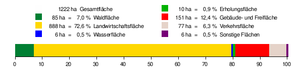
According to data from the State Statistical Office , as of 2014.
history
First known documentary mention
The first known documentary mention of the municipality of Böbingen comes from the year 1291 . A document dated November 30, 1291 shows that Gotteszell Monastery bought a farm in "Bebingen".

The history of Böbingen, however, goes back much further than 1291. The Limes running through Böbingen , the Roman fort at Unterböbingen , many historical finds from excavations (e.g. Alemannic graves) and the Michael Church in Oberböbingen are indications of this. The historical field name “Bürgle” indicates the old fortifications at this location. During the first excavations in 1885/86 by the retired Chief of Staff of the Württemberg Army, Major General Eduard von Kallee , Unterböbingen was recognized as a fort due to military strategic considerations and examined by Major Heinrich Steimle on behalf of the Reich Limes Commission in 1892 . The Roman military thermal bath , which was also available to the civilian residents of the village that was built outside the fort, could be seen in 1978 north of the fort on a high terrace on the edge of the Remstal. The Unterböbingen fort and the surrounding ground monuments have been part of the UNESCO World Heritage as a section of the Upper Germanic-Rhaetian Limes since 2005 .
The middle age
In the Middle Ages Oberböbingen first belonged to Ulrich von Rechberg , then to the knight Albrecht Hack. In 1358 extensive areas came to the Königsbronn monastery . In the 14th century Böbingen belonged to a wide variety of landlords. These included the monasteries in Königsbronn, Gotteszell , the Augustinian monastery , the hospital and several secular landlords.
Unterböbingen was largely owned by the Schwäbisch Gmünd monasteries . The possessions of the Königsbronn monastery came to Duke Christoph von Württemberg in 1556 . In 1803, the other spiritual property came to Württemberg in the course of secularization .
In the Middle Ages, Böbingen's population consisted mainly of farmers who did not have their own land and who had to do labor for the few landowners. The time of the Reformation brought serious changes for Böbingen as well. Both Böbingen churches became Protestant, and so the subjects had to accept the Protestant faith. Only a few residents who belonged to the Free Imperial City of Gmünd on the farms remained Catholic.
The Thirty-Year War
During the Thirty Years' War , Unterböbingen lost all of its inhabitants. The reason for this was that Unterböbingen was directly on the Heerstraße through the Remstal and was thus directly affected by the war.
From 1660, Gmünd was resettled in Unterböbingen. This made the population Catholic. In Oberböbingen, many residents died of the plague during this time . The billeting of foreign troops resulted in looting and murder in many houses. The inhabitants fled to the neighboring forests.
18./19. century
In the 18th and 19th centuries, the residents of Oberböbingen continued to live mainly from agriculture. There were few craftsmen and merchants. In Unterböbingen there were more craftsmen who also did external trade. The majority of the population lived from agriculture, however.
When the new administrative structure was implemented in the Kingdom of Württemberg , which was founded in 1806 , Ober- and Unterböbingen were assigned to the Oberamt Gmünd .
With the construction of the Remstalbahn , Unterböbingen received a fast connection to the east (Aalen) and west (Stuttgart) in the route network of the Württemberg Railways .
20./21. century
The Böbingen – Heubach railway line was built in the 20th century and was handed over to its destination in 1920. In 1933 the Oberböbinger outdoor pool was inaugurated. During the district reform in Württemberg during the Nazi era , Unter- and Oberböbingen became part of the Gmünd district in 1938 . In the same year the two communities were merged into one community. From 1938 to 1957, the forcibly united community was called Unterböbingen. The suburb ofzimmer was spun off and incorporated into the then independent municipality of Herlikofen , while the suburb of Beiswang came from Bargau to Böbingen.
During the Second World War , French, Russian and Polish prisoners of war were forced laborers who had to work on the farm and were mostly housed in shared accommodation in Heubach and Oberböbingen. In 1944, heavy bomber squadrons often flew over Böbingen. According to contemporary witness reports, there was also an aerial battle over the place. Shortly before the end of the war in 1945, the area around Unterböbingen train station was often the target of enemy fighter bombers. Nevertheless, the damage in Böbingen remained relatively minor. On April 22, 1945, despite tank traps, American soldiers occupied Unterböbingen at 1:45 p.m. Both Böbingen mayors left their official business in view of the advance of the US Army and did not prevent the community from surrendering. The head of the Diakonie used the favor to wave a white cloth with a Red Cross armband towards the Americans on the railway bridge, which prevented a bombardment of Unterböbingen. Oberböbingen, on the other hand, was not occupied until April 23, 1945 at 7:00 p.m.
After the Second World War, many refugees from the east settled in Böbingen. Due to the development of numerous building areas, Böbingen had an above-average population growth. The community had become part of the American zone of occupation in 1945 and thus belonged to the newly founded state of Württemberg-Baden , which was merged into the current state of Baden-Württemberg in 1952.
In 1947, Bargau applied for Beiswang to be reorganized, and in a hearing, the Beiswang who were eligible to vote voted to remain with Unterböbingen.
Since 1957 the municipality as a whole has been officially called Böbingen an der Rems by a local council resolution .
In a vote in 1971, those entitled to vote decided in favor of the community's independence and against incorporation into Heubach.
Through the district reform in Baden-Württemberg , Böbingen came to the newly formed Ostalbkreis in 1973 .
Today the community is predominantly a residential community with a still rural character.
Religions
Since the introduction of the Reformation, Oberböbingen has been dominated by Protestants , while in Unterböbingen the Catholics dominate. Today there is also an Evangelical Free Church Community .

Organ in the Catholic parish church

The Protestant parish church of St. Michael is of Romanesque origin.

The pilgrimage chapel on the road to Beiswang was built around 1680.


politics
Administrative community
The community has been a member of the Rosenstein administrative association based in Heubach since 1972 .
Municipal council
The municipal council election on May 25, 2014 brought the following result:
- CDU 40.5% (+4.4) - 6 seats (+1)
- FWG 33.1% (-3.3) - 4 seats (-1)
- SPD / Independent Citizens 26.4% (-1.1) - 4 seats (+4) 1
coat of arms
Blazon : In a divided shield above in red a silver chapel standing on the division with a roof turret, below in green a slanted golden bell.
The coat of arms was presented to the former municipality of Unterböbingen as early as 1930 by the Stuttgart archive department. Above it shows the former Kolomanskapelle , the bell refers to a local legend according to which wild boars dug a buried bell out of the ground.
The municipality flag is black and red.
Partnerships
Böbingen has had a partnership with the municipality of Custines near Nancy since 1971 .
Economy and Infrastructure
traffic
The Heubachbahn existed between 1920 and 1975 . It connected Böbingen, where it branched off from the Remsbahn , with Heubach. The "Park on the old railway embankment" was created on and next to the previous route as part of the Remstal Garden Show 2019 .
Regional train trains on the Remsbahn ( Stuttgart - Aalen ) and the federal road 29 ( Waiblingen - Nördlingen ) connect Böbingen with the national transport lines. The next motorway connection is junction 115 (Aalen / Oberkochen) of federal motorway 7 , approx. 24 km away via the B29 towards Aalen and the L1084.
Local public transport rail and bus lines can be used at the tariffs of the OstalbMobil transport cooperative as well as at the tariffs of the respective transport company.
Long-distance cycle routes
Several cycle paths cross the municipality:
- The Remstal cycle path accompanies the Rems up to its confluence with the Neckar.
- The German Limes Cycle Route follows the Upper German-Raetian Limes over 818 km from Bad Hönningen on the Rhine to Regensburg on the Danube .
education
With the school at the Roman fort , Böbingen has a primary and secondary school . There are also two kindergartens in town.
Culture and sights
Böbingen is located on the Franconian-Swabian Way of St. James .
Remstal Garden Show 2019
_Wei%C3%9Fes_Dach.jpg)
From May 10 to October 20, 2019, a green project of the state of Baden-Württemberg will take place in the Remstal , in which Böbingen is also participating. This Remstal garden show 2019 is one of the "small" garden shows that alternate annually with the state garden shows.
In this context, the "Park on the old railway embankment" was created west of the state road L1162 to Heubach, south of the Rewe supermarket. It is located on and alongside the former route of the Heubachbahn . The course of the Klotzbach , which flows into the Rems a little further north , was also included in this five- hectare park . Böbingen took part in the “16 stations”, the garden show's architectural project, with the “White Roof”, which is located in the forest area of the new park and appears to float in the trees.
![]()
Personalities
Honorary citizen
So far, Böbingen has only granted honorary citizenship once, to Adolf Schneider († 1979).
Other people associated with Böbingen
- Ferdinand Ludwig Immanuel Dillenius (1791–1871), Protestant clergyman; was pastor in Oberböbingen from 1817 to 1824
- Uwe Ernst (* 1947), painter and draftsman; lives and works in Böbingen since 1989
- Karl Hilsenbek (* 1957), politician; was mayor of Böbingen from 1986 to 2003
literature
- Municipality of Böbingen an der Rems (Ed.): Böbingen an der Rems. Portrait of a community , Süddeutscher Zeitungsdienst, Aalen 1986.
- Municipality of Böbingen an der Rems (publisher): 700 years of Böbingen / Rems 1291–1991. 20 years partnership with Custines 1971–1991 , Wahl-Druck, Aalen 1991.
Web links
Individual evidence
- ↑ State Statistical Office Baden-Württemberg - Population by nationality and gender on December 31, 2018 (CSV file) ( help on this ).
- ^ The state of Baden-Württemberg. Official description by district and municipality. Volume IV: Stuttgart district, Franconian and East Württemberg regional associations. Kohlhammer, Stuttgart 1980, ISBN 3-17-005708-1 , pp. 728-730.
- ↑ Municipality of Böbingen an der Rems (ed.): Böbingen an der Rems. Portrait of a community , Süddeutscher Zeitungsdienst, Aalen 1986, p. 33.
- ↑ State Statistical Office, area since 1988 according to actual use for Böbingen an der Rems.
- ↑ https://www.boebingen.de/index.php?id=47 Böbingen's history
- ↑ Municipality of Böbingen an der Rems (ed.): Böbingen an der Rems. Portrait of a community , Süddeutscher Zeitungsdienst, Aalen 1986, p. 12.
- ↑ Heinz Bardua: The communal coat of arms of the Ostalb district. Ostalb-Einhorn 10 (1983), pages 75-88
- ↑ Heinz Bardua: District and community arms in Baden-Württemberg. Volume 1: The district and community coats of arms in the Stuttgart administrative region . Landesarchivdirektion Baden-Württemberg (ed.), Konrad Theiss Verlag, Stuttgart 1987, 158 pages, ISBN 3-8062-0801-8
- ↑ Claudia Bell: Feeling strengthened for Fellbach and the Rems Valley. In: Stuttgarter Nachrichten. October 21, 2019, accessed December 24, 2019 .
- ↑ Architecture with 16 stations on remstal.de. Retrieved June 21, 2019.

Basking | Abtsgmünd | Adelmannsfelden | Bartholomä | Böbingen an der Rems | Bopfingen | Durlangen | Ellenberg | Ellwangen (Jagst) | Eschach | Essingen | Göggingen | Gschwend | Heubach | Hypocrites | Hüttlingen | Iggingen | Jagstzell | Kirchheim am Ries | Lauchheim | Leinzell | Lorch | Mögglingen | Mutlangen | Neresheim | Newbie | Obergröningen | Oberkochen | Rainau | Riesbürg | Rosenberg | Ruppertshofen | Schechingen | Schwäbisch Gmünd | Spraitbach | Stödtlen | Panel red | Tannhausen | Unterschneidheim | Waldstetten | Westhausen | Words