
Preveza (regional unit)
|
Preveza Regional Unit Περιφερειακή Ενότητα Πρέβεζας (Πρέβεζα) |
|
|---|---|
 |
|
| Basic data | |
| State : | Greece |
| Region : | Epirus |
| Area : | 1,036 km² |
| Residents : | 57,491 (2011) |
| Population density : | 55.5 inhabitants / km² |
| NUTS 3 code no. : | - |
| Structure: | 3 municipalities |
| Website: | www.preveza.gr |
The regional district of Preveza ( Greek Περιφερειακή ενότητα Πρέβεζας Periferiaki enotita Prevezas ) is one of the four regional districts of the Greek administrative region Epirus . It was founded in 1915 as a prefecture , which lasted until the Greek administrative reform in 2010 . Apart from the allocation of seats in elections, the area, which has continued to exist as a regional district, no longer has any political significance except as a constituency for the Greek parliament. It includes the parishes of Parga , Preveza and Ziros .
geography
Preveza is located in the west of mainland Greece in the south of Epirus . It is bounded to the south by the Ambracian Gulf and to the west by the Ionian Sea . To the east, the Louros River forms the border with the Arta area . To the north, the Preveza prefecture borders on Thesprotia and the regional district of Ioannina . The area is dominated in its southern part by the plain north of the Ambracian Gulf. The largest city of Preveza is located on the headland in the southwest, which extends towards the peninsula of Aktio and is only separated from it by the narrow Preveza-Aktio strait. The northwest on the coast of the Ionian Sea is characterized by wooded hilly landscapes: the main town of this region is the small town of Parga with the municipality of the same name. To the southeast of Parga, between the northern Ambracian Plain and the Ionian Sea, the Zalongo mountain ranges extend from northwest to southeast. To the northeast, the area touches the western foothills of the Pindos Mountains. The largest river, apart from the border river Arachthos, is the Louros: it flows northeast of the city of Preveza into the Ambracian Gulf. To the east of the Louros estuary, immediately north of the coast of the Ambracian Gulf, there are extensive lagoons (Limnothalasses), which together represent an important wetland biotope. However, the majority of these lagoons are located in the area of Arta Prefecture. The river Acheron runs in the north of the prefecture and forms the border with the prefecture Thesprotia for long stretches.
history
In ancient times, today's prefecture area belonged mainly to the Kingdom of Epirus. After the defeat of Epirus against the Roman Empire, the Romans gradually took control of what is now the prefecture area. After the naval battle of Actium (Aktio), Nikopolis was founded near the present-day prefecture capital of Preveza . With the division of the empire in AD 395, the area of today's prefecture falls to the Eastern Roman, later the Byzantine Empire . The Byzantines can essentially control what is now the prefecture until 1204. With the conquest of Constantinople in 1204 as part of the Fourth Crusade and the subsequent (temporary) disintegration of the Byzantine state into Crusader states and successor states dominated by Byzantine, today's prefecture area becomes part of the Despotate of Epirus . This political structure was replaced in the 14th and 15th centuries by the Ottoman Empire , which retained control over the present-day prefecture area until the First Balkan War in 1912. The unrest that broke out during the Greek Revolution in 1821 was put down by the Ottoman Empire. The "dancing women of Zalongo" gained particular prominence during these disputes.
In its present form, the area of the prefecture became part of the modern Greek state in 1913 after the Second Balkan War . The prefecture came under Greek control during the First Balkan War in 1912. In the battle of Pende Pigadia (Πέντε Πηγάδια) on October 15, 1912 in the area of today's Filippiada, the Greek army succeeded in conquering today's prefecture area. From 1925 to 1946, Lefkada Province was also part of the prefecture's territory. In April 1941, the prefecture, like the rest of Greece, was conquered by German troops as part of the Wehrmacht 's campaign in Greece and Yugoslavia . Until September 1943, the prefecture area was controlled by the Italian occupying forces. After Italy surrendered to the Allies in September 1943, the Wehrmacht troops took control of the prefecture area. In October 1944 the German troops withdrew.
economy
The economic pillars of the prefecture are agriculture, in coastal regions fishing and tourism. The most important tourist center is the small town of Parga in the northwest of the prefecture on the Ionian Sea.
traffic
Preveza is passed by three national roads. The well-developed national road 111 (European route 55) runs along the coast of the Ionian Sea from Parga to Preveza. In Preveza it meets the national road 21, which runs from the town of Preveza along the river Louros to Filippiada, the second largest town in the prefecture. The section of national road 21 (European route 55), which runs south of the city of Preveza, leads through the 1,600 m long submarine Preveza-Aktio tunnel to Actium (including Aktio airport ) and on to Lefkada. The prefecture only has a direct connection to the Greek motorway network in its northeast near Filippiada: there is a junction with the motorway 5 . In the future, motorway 50 will run south of Preveza on the Aktio peninsula, which will connect Lefkada with Amfilochia via Vonitsa . This project was put out to tender in early 2009.
The city of Preveza is a port of high importance.
The area does not have a rail link, nor does it have an international airport. The Preveza-Aktio international airport located on the Actium Peninsula is, however, in the Aetolia-Acarnania area .
The former provinces of Nikopolis and Parga were abolished in 1997.
gallery

The city of Preveza, the Preveza-Aktio strait and the airport of the same name (aerial view)

The nymphaeum of ancient Nicopolis north of the city of Preveza
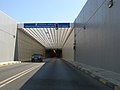
Preveza-Aktio underwater tunnel

Parga Bay


literature
- Epiros / Thessalia Map. 1: 250,000 . Road Editions, Athens, ISBN 960-8481-17-1 .
- Marco Polo Greece road map. 1: 750,000. Mairs Geographic Holdings.
Individual evidence
- ↑ Results of the 2011 census at the National Statistical Service of Greece (ΕΛ.ΣΤΑΤ) ( Memento from June 27, 2015 in the Internet Archive ) (Excel document, 2.6 MB)
Achaia | Argolis | Arcadia | Arta | Athens | Aetolia-Acarnania | Boiotia | Halkidiki | Chania | Chios | Dodecanese | Drama | Elis | Euboea | Evrytania | Evros | Florina | Fokida | Fthiotida | Grevena | Imathia | Ioannina | Heraklion | Karditsa | Kastoria | Kavala | Kefallinia | Kilkis | Kerkyra | Corinthia | Kozani | Cyclades | Laconia | Larisa | Lasithi | Lefkada | Lesbos | Magnesia | Messenia | Pella | Ostattika | Pieria | Piraeus | Preveza | Rethymno | Rodopi | Samos | Serres | Thesprotia | Thessaloniki | Trikala | West Attica | Xanthi | Zakynthos