Sieghartskirchen
|
market community Sieghartskirchen
|
||
|---|---|---|
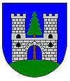
| coat of arms | Austria map | |
|
|
||
| Basic data | ||
| Country: | Austria | |
| State : | Lower Austria | |
| Political District : | Tulln | |
| License plate : | TU | |
| Surface: | 61.68 km² | |
| Coordinates : | 48 ° 15 ' N , 16 ° 1' E | |
| Height : | 205 m above sea level A. | |
| Residents : | 7,526 (January 1, 2020) | |
| Population density : | 122 inhabitants per km² | |
| Postal code : | 3443 | |
| Area code : | 02274 | |
| Community code : | 3 21 31 | |
| NUTS region | AT126 | |
| Address of the municipal administration: |
Wienerstraße 12 3443 Sieghartskirchen |
|
| Website: | ||
| politics | ||
| Mayoress : | Josefa Geiger ( ÖVP ) | |
|
Municipal Council : ( 2020 ) (33 members) |
||
| Location of Sieghartskirchen in the Tulln district | ||
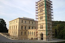
 town hall |
||
| Source: Municipal data from Statistics Austria | ||
Sieghartskirchen is a market town with 7526 inhabitants (as of January 1, 2020) in the Tulln district in Lower Austria .
geography
The area of the market municipality covers 61.59 square kilometers on 24 cadastral communities . 36.01 percent of the area is forested.
The municipality is mainly located in the catchment area of the Kleine Tulln , through which Sieghartskirchen itself also flows. The northwest lies on the Große Tulln , in the far east there are small areas that drain over the Altbach and the main ditch to the Bie or beyond the Riederberg into the Gablitzbach .
The highest elevations are in the southeast in the Flysch - Wienerwald , where northeast of the Riederberg on the west shoulder of the Rauchbuchberg (approx. 435 m above sea level ) is also the highest in the municipality. Also worth mentioning here are the Klosterberg near Ried ( 420 m above sea level ) and the Frauenberg ( 382 m above sea level ) and the Haberg ( 409 m above sea level ) near Kogl. Upstream of the flysch zone is the subalpine Molasse with the Hohe Warte ( 400 m above sea level , see Buchberg near Neulengbach ) between Elsbach and Rappoltenkirchen. The north and west lie in the Molasse zone , which here consists of Robulus-Schlier and reaches the highest elevation at Breiten Anger ( 374 m above sea level , between Röhrenbach and Dietersdorf).
Community structure
The municipality includes the following 25 localities (population in brackets as of January 1, 2020):
- Abstetten (192)
- Dietersdorf (307)
- Einsiedl (98)
- Elsbach (569)
- Flachberg (45)
- Gerersdorf (67)
- Gollarn (124)
- Henzing (194)
- Kogl (419)
- Cracking (17)
- Kreuth (189)
- Kronstein (25)
- Ollern (492) including Waldheim and Weideck
- Opping (70)
- Penzing (43)
- Plankenberg (302)
- Ranzelsdorf (94)
- Rappoltenkirchen (445) including the Tyrolean settlement
- Reichersberg (169)
- Ried am Riederberg (356)
- Riederberg (169)
- Röhrenbach (161)
- Sieghartskirchen (2049)
- Wagendorf (57)
- Weinzierl (199)
The community consists of the cadastral communities of Abstetten, Dietersdorf , Einsiedl, Elsbach, Flachberg, Gerersdorf, Gollarn, Henzing, Kogl, Kraking, Kreuth, Kronstein, Oepping, Ollern, Penzing, Plankenberg, Ranzelsdorf, Rappoltenkirchen, Reichersberg, Ried am Riederberg, Röhrenbach, Sieghartskirchen, Wagendorf and Weinzierl near Ollern.
Neighboring communities
history
The oldest mention of a place in the municipality of Sieghartskirchen refers to Abstetten , which appears for the first time in a wisdom between 983 and 991 as "Abbatesteti" .
All parishes in the Sieghartskirchen area were created through the splitting off of the large Carolingian original parish of Abstetten. The center of the medieval settlement complex Sieghartskirchens was the fortified church , built on a hill and surrounded by the rectory and cemetery. At the foot of the church hill an irregular settlement spread out, which was later expanded as a street village towards Preßbaumer Straße as planned .
The place name Sieghartskirchen is derived from a Sieghard, who founded the church here and probably belonged to the Sieghardinger family . The first written mention of Sieghartskirchens dates from the year 1051. The German Emperor Heinrich III. then gave the Reichsgut Sieghartskirchen to the Marienstift in Hainburg .
In 1228 the Bavarian Count Palatine Rapoto II von Ortenburg transferred the parish of Sieghartskirchen to the Augustinian Canons' Monastery of Baumburg in Bavaria, which was able to preserve its rights until the abolition of the monastery in 1803.
Sieghartskirchen had already developed into a local market center in the Middle Ages, which was able to take advantage of the Reichsstrasse Vienna – Linz in particular . The first certain mention that Sieghartskirchen as market identifies, contains a land register of the parish from the year 1581 a postal station was in Sieghartskirchen In the 16th century Viennese Reichsstraße established that played up to the building of the railroads in the 19th century a significant role . For a long time the main traffic line leading from Vienna to the west ran through Sieghartskirchen. Sieghartskirchen missed the connection to the railway network in the 19th century; the numerous projects of a Wienerwaldbahn all failed due to the question of financing.
In 1934 the farmer and farm owner Alois Gaidosch senior was born in the village of Ollern. murdered by his son. The perpetrator was soon arrested, found guilty at the Vienna Regional Criminal Court, sentenced to death and executed .
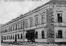
The post station made Sieghartskirchen a popular place to stay overnight from around 1700. From the 19th century to the Second World War it was a popular summer resort. Since the interwar period, the municipality, starting from the Riederberg area , has become a preferred settlement area for the Viennese. In the past, a brick kiln, two sawmills and a textile company were the largest companies in Sieghartskirchen, but today, with around 370 employees, Rudolf Berger's meat production is the largest company in the community. The butchery Berger was founded in 1890 by Michael Berger, he was still on the road with a handcart at the time. In 1980 the community bought the former post house with the spacious park and adapted the classicist building as a town hall.
In 1590, Ried bei Riedersberg was the epicenter of the most severe earthquake in Austria to date, in which a church tower collapsed in Vienna.
Population development
According to the results of the 1869 census , there were 4,353 inhabitants. After the First World War, the population stagnated for a long time or even decreased; the lowest value was reached in 1961 with 4007 inhabitants. The population has been growing again since the 1970s: in 1991 the market town had 5812 inhabitants, in 2001 it was 6674 and in 2010 it was 7011.

Community partnerships
politics
The municipal council has 33 members.
- With the municipal council elections in Lower Austria in 1990, the municipal council had the following distribution: 16 ÖVP, 11 SPÖ and 2 FPÖ. (29 members)
- With the municipal council elections in Lower Austria in 1995, the municipal council had the following distribution: 16 ÖVP, 10 SPÖ and 3 FPÖ.
- With the municipal council elections in Lower Austria in 2000, the municipal council had the following distribution: 14 ÖVP, 12 SPÖ and 3 FPÖ.
- With the municipal elections in Lower Austria in 2005 , the municipal council had the following distribution: 16 ÖVP, 12 SPÖ and 1 Greens.
- With the municipal council elections in Lower Austria 2010 , the municipal council had the following distribution: 17 ÖVP, 8 SPÖ, 2 FPÖ, 1 Greens and 1 FBL - Free Citizens List. (29 members)
- With the municipal council elections in Lower Austria in 2015 , the municipal council had the following distribution: 18 ÖVP, 8 SPÖ, 4 FPÖ, 2 Greens and 1 FBL-Freie Bürgerliste.
- With the municipal council elections in Lower Austria 2020 , the municipal council has the following distribution: 22 ÖVP, 5 SPÖ, 3 Greens and 3 FPÖ.
- mayor
- 1994–2008 Josef Ungler (ÖVP)
- 2008–2014 Johann Höfinger (ÖVP)
- since 2014 Josefa Geiger (ÖVP)
Culture and sights
- Burgruine Ried am Riederberg : On the mountain about 1 km south of Ried am Riederberg are the architectural remains of probably in the 12th century castle built Ried, which until the first half of the 15th century as the seat of the noble family of the taverns of Ried detectable is. Today's ruin consists of a Romanesque round tower ruin, which, due to the construction technology, can be classified in the first half of the 13th century at the latest. Remains of the walls of a kennel and an outer bailey from the late 14th century can still be seen. The wall and ditch systems extend into the valley. The ruins were used as a quarry in the 17th century and were removed, as archaeological finds show. The listed castle complex has been archaeologically researched and renovated since 2010.
- Sancta Maria in Paradyso : A Franciscan monastery of Sancta Maria in Paradyso was founded around 1440 in a valley south-east of Ried am Riederberg. The superiors of the order liked the solitude of the place, so the novitiate and the university were relocated here. Much of the monastery fell victim to a fire in 1509. In the course of the first Turkish siege of Vienna , Turkish troops swarmed into the Vienna Woods and finally destroyed the Franciscan monastery, 18 priests were killed. The walls of a single-nave, late Gothic church are still preserved today. The tradition of the Ried monastery was continued by the Franciscan monastery in Neulengbach, which was newly founded around 1620. The castle of Sieghartskirchen, which was located near today's "Gasthaus zum Mohren", was destroyed by the Turks in 1529.
- Catholic parish church Abstetten hl. Martin: The church is raised in the middle of the village of Abstetten with a cemetery surrounded by an embankment wall. The Gothic church, which has been converted to baroque style, has a mighty tower that can be seen from afar.
- Catholic parish church Ried am Riederberg hl. John the Baptist
- Catholic parish church Ollern hl. Rochus
- Catholic parish church Sieghartskirchen hl. Margareta
- Plankenberg Castle: Some places in the region are also known nationwide through various historical events. The Plankenberg hunting lodge, a three-story building erected in the 17th century, housed an educational institution for nobles between 1814 and 1826. From 1885 the landscape painter Emil Jakob Schindler lived in Plankenberg Castle with his wife and two daughters. He gathered a small group of artists around him; Marie Egner , Tina Blau , Olga Wisinger-Florian , Carl Moll , Theodor von Hörmann and Hugo Darnaut belong to the Plankenberg painter's circle, whose works are attributed to Austrian mood impressionism. One of Schindler's favorite motifs was the poplar avenue on the Linzer Reichsstraße, not far from Plankenberg Palace. Schindler dedicated three monumental depictions to this avenue. Alma Mahler-Werfel , Schindler's daughter, spent years of her childhood in Plankenberg. In her book My Life , she writes about it: “I spent most of my childhood in this old castle. For me it was full of horror, legends and beauty. "
- Rappoltenkirchen Castle : In Rappoltenkirchen, too, the castle is the most important building in the town of the same name. At the beginning of the 19th century, the rule and the Rappoltenkirchen Castle came into the possession of the Greek Sina family. Georg Simon Sina (1783–1856) was the most important financier of the Greek colony in Vienna ; after Rothschild , he was then the second richest man in Austria. In 1854, Sina had a large mausoleum built on the east side of the palace gardens. The bones of the Greek freedom hero Alexander Fürst Ypsilanti rested there from 1906 to 1964 , after the burial in the Sankt Marxer Friedhof in Vienna, they were transferred to Thessaloniki in 1964 . Baron Simon Georg Sina commissioned the Danish-born Theophil Hansen , who had built the parliament building and the stock exchange in Vienna, with the renovation of the Rappoltenkirchen Palace. Hansen redesigned it in the neoclassical style into a " Ringstrasse Palace in the Vienna Woods". Via a daughter of Sina, Rappoltenkirchen Castle came into the possession of the Greek Ypsilanti family, who owned it until the end of the 20th century.
- Riederbergstraße: The road from Ried am Riederberg to Riederberghöhe, part of Wiener Straße , was feared for a long time because of the considerable incline. Carriages needed a leader, in the middle of the 19th century the Riederbergstraße was expanded in the form of serpentines . With the advent of the automobile, hill climbs were held again and again. Even after the road was paved in 1934, the danger of the road remained, where spectacular accidents occurred in the area of the serpentines when the road was wet.
- "Roman grave": in Kronstein, on the municipality border with Pressbaum, there are several Noric-Pannonian barrows . In the largest of these (referred to as the “Roman grave” on the maps), the restored burial chamber was made visible in the 1960s (however, it was blocked by a grid). The place of the grave is connected to the network of Troppberg hiking trails.
economy
In 2001 there were 231 non-agricultural workplaces, agricultural and forestry businesses according to the 1999 survey 176. According to the 2001 census, the number of people in employment at the place of residence was 3137. The 2001 participation rate was 48.23 percent.
The sausage and ham producer Fleischwaren Berger , which was founded in 1890, employs 450 people and is represented in the food trade throughout Austria.
education
There is a Sieghartskirchen elementary school in the community .
Personalities
- Honorary citizen of the community
- 2008 Josef Ungler, former mayor
- 2012 Martin Grüßenberger (1945–2019), pastor of Ollern and Ried am Riederberg 1977–2014
- Sons and daughters of the church
- Josef Faustenhammer (1934–2017), member of the Federal Council
- Leopold Grünzweig (1923–2003), mayor 1970–1972, member of the state parliament and deputy governor
- Roman Gutscher (1897–1967), Mayor 1945–1964, former member of the Federal Council
- Franz Hadamowsky (1900–1995), writer and theater scholar
- Karl Maria Heller (1864–1945), zoologist
- Johann Höfinger (* 1969), member of the National Council
- Hildegard Joos (1909–2005), painter, representative of abstract painting and constructivism
- Johann Adam Mihm (1774–1851), pastor, historian and chronicler
- Helmut Plattner (1940–2016), jazz musician
- Erich Rabl (* 1948), professor, historian and local researcher
- Wolfgang Grünzweig , musician
literature
- Roland Dobersberger: Abstetten 1987. 1000 years local parish, 850 years parish. Vienna 1987.
- Roland Dobersberger: Sieghartskirchen. A home book. Vienna / Klosterneuburg 2001.
- Josef Koller: Ollern. Place and house chronicle. Ollern 1983.
- Erich Rabl: Sieghart churches. Commemorative publication on the 750th anniversary award of the Sieghartskirchen parish to Baumburg monastery. 100 years of the Sieghartskirchen volunteer fire department. Sieghartskirchen 1978.
- Erich Rabl: Sieghart churches in old views. Zaltbommel 1982.
- Erich Rabl: Rappoltenkirchen. 100 years of the Rappoltenkirchen Volunteer Fire Brigade 1883–1983. Highlights from the history of Rappoltenkirchen. Rappoltenkirchen 1983.
- Erich Rabl: Sieghartskirchen 1890–1980. Album Verlag, Vienna 2006, ISBN 3-85164-159-0
Web links
- 32131 - Sieghartskirchen. Community data, Statistics Austria .
- Entry via Schloss Plankenberg to Burgen-Austria
- Entry via Schloss Rappoltenkirchen to Burgen-Austria
Individual evidence
- ^ Rudolf Oberhauser : The geological structure of Austria. Springer-Verlag, 2013, p. 167. online in the Google book search
- ↑ Statistics Austria: Population on January 1st, 2020 by locality (area status on January 1st, 2020) , ( CSV )
- ↑ The document speaks of quoddam predium Sigehartteschiriha dictum in comitatu Adalberti marchionis in pago Ostericha situm ("an estate called Sieghartskirchen in the county of Margrave Adalbert located in the Gau Austria"). In: Document 276, Harry Bresslau and Paul Kehr (eds.): Diplomata 16: The documents of Heinrich III. (Heinrici III. Diplomata). Berlin 1931, pp. 376–377 ( Monumenta Germaniae Historica , digitized version )
- ↑ School year 1934/1935. In: http://www.direle.at . August 2, 2015, accessed August 11, 2018 .
- ^ List of earthquakes in Austria
- ^ Result of the local council election 1995 in Sieghartskirchen. Office of the Lower Austrian State Government, March 30, 2000, accessed on February 3, 2020 .
- ^ Election result of the municipal council election 2000 in Sieghartskirchen. Office of the Lower Austrian State Government, February 4, 2005, accessed on February 3, 2020 .
- ^ Election result of the municipal council election 2005 in Sieghartskirchen. Office of the Lower Austrian State Government, March 4, 2005, accessed on February 3, 2020 .
- ^ Election result of the municipal council election 2010 in Sieghartskirchen. Office of the Lower Austrian State Government, October 8, 2010, accessed on February 3, 2020 .
- ↑ Election result of the 2015 municipal council election in Sieghartskirchen. Office of the Lower Austrian State Government, December 1, 2015, accessed on February 3, 2020 .
- ↑ Results of the municipal council election 2020 in Sieghartskirchen. Office of the Lower Austrian State Government, January 26, 2020, accessed on February 3, 2020 .
- ↑ 125 years of sausage specialist Berger on the website of the Lower Austrian state government from July 3, 2015, accessed on July 8, 2015.
- ↑ Farewell ceremony and appointment as an honorary citizen netteam.at, November 7, 2008.
- ↑ https://www.noen.at/tulln/ollern-trauer-um-pfarrer-tulln-nachruf-gedenken-reime-140591113# , accessed on April 19, 2019
- ↑ World famous in Austria - 50 years of Austropop


