
Rimberg (Schmallenberg)
|
Rimberg
City of Schmallenberg
Coordinates: 51 ° 13 ′ 3 ″ N , 8 ° 20 ′ 57 ″ E
|
||
|---|---|---|
| Height : | 610 (602.5-622.5) m above sea level NHN | |
| Residents : | 7 (Dec. 31, 2019) | |
| Postal code : | 57392 | |
| Primaries : | 02974, 02977 | |
Location of Rimberg in Schmallenberg |
||
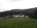
 Distant view of Rimberg
|
||

Rimberg is a district of the town of Schmallenberg in the North Rhine-Westphalian Hochsauerlandkreis .
Geographical location
Rimberg is located in the northwest of the Rothaargebirge about 8.5 km northeast of the Schmallenberg core city, 4.2 km northeast of Bad Fredeburg , 1.6 km west of Osterwald and 3.1 km south-southwest of Gellinghausen , all of which belong to Schmallenberg. West-northwest of the 602.5 to 622.5 m above sea level. NHN located hamlet rises the Rimberg ( 713.2 m ) and east-southeast the Hunau ( 818.5 m ). The state road 776 runs through it between Bad Fredeburg and Gellinghausen and runs here between the Rimberg in the west-northwest and the Hunau in the east-southeast. To the north of Rimberg is the nature reserve Offenland area Rimberg and to the east the nature reserve residual grassland around Gellinghausen and the open land islands south of Gellinghausen to Rimberg .
history
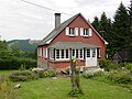
Rimberg's first house was built in 1860. The later Hotel Knoche has developed from the former inn . From 1943 to 1945 it was a maternity home of the National Socialist People's Welfare (NSV). 498 children were born there during this time. Next to the hotel there is a former farm , today a sled dog breed with a guesthouse, and a residential building, now a weekend house. Until the municipal reorganization, Rimberg belonged to the municipality of Bödefeld-Land and was on the border with Fredeburg. On January 1, 1975, the place was incorporated into the city of Schmallenberg.
Heinrich Lübke (1894–1972), Federal Minister for Food, Agriculture and Forestry from 1953 to 1959 and the second Federal President of the Federal Republic of Germany from 1959 to 1969 , stayed at Hotel Knoche from the mid-1950s until shortly before his death. He made sure that the state road 776 at Rimberg was expanded and moved away from the hotel. Photos in the building were reminiscent of the vacations from Lübke until the hotel fire in 2011.
On the night of February 4th to 5th, 2011, the hotel was almost completely destroyed by fire. After the reconstruction, the Hotel Knoche reopened in summer 2013. In 2013 the hotel went bankrupt and has been running under the name Hotel Rimberg since mid-2014 .

House Rimberg 2 , in Rimberg
House Rimberg 3 , in Rimberg

Hotel Knoche on February 5, 2011
Hotel Knoche 2014


Web links
Individual evidence
- ↑ Population figures Schmallenberg 2019 , accessed on July 3, 2020, from schmallenberg.de
- ↑ Topographical Information Management, Cologne District Government, Department GEObasis NRW ( Notes )
- ^ Sauerlandkurier : Knoche Rimberg , page 10, from August 11, 2013
- ^ Federal Statistical Office (ed.): Historical municipality directory for the Federal Republic of Germany. Name, border and key number changes in municipalities, counties and administrative districts from May 27, 1970 to December 31, 1982 . W. Kohlhammer, Stuttgart / Mainz 1983, ISBN 3-17-003263-1 , p. 335 f .
- ↑ Article Brand am Rimberg , February 5, 2011, in: Der Westen retrieved on February 5, 2011

Almert | Altenhof | Altenilpe | Arpe | Bad Fredeburg | Berghausen | Berghof | Bödefeld | Brabecke | Bracht | Dorlar | Dornheim | Ebbinghof | Felbecke | Fleckenberg | Föckinghausen | Gellinghausen | Gleidorf | County | Grimminghausen | Hanx leather | Harbecke | Lifting basin | Heiminghausen | Herschede | Hiege | High bone | Holthausen | Dog sauces | Huxel | Indian hen | Hunting lodge | Keppel | Kirchilpe | Kirchrarbach | Kückelheim | Landenbeckerbruch | Lanfert | Latrop | Lengenbeck | Lenne | Mailar | Menkhausen | Middle sorpe | Monk child | Nesselbach | Niederberndorf | Niederhenneborn | Niedersorpe | Kidney drop | Nordenau | Oberberndorf | Oberhenneborn | Oberkirchen | Oberrarbach | Obersorpe | Obringhausen | Ohlenbach | Osterwald | Rehsiepen | Rellmecke | Rimberg | Red bush | Jump | Selkentrop | Sellinghausen | Sellmecke | Silberg | Sögtrop | Sonderhof | Störmecke | Twismecke | Forest | Waidmannsruh | Walbecke | Werntrop | Werpe | Westernbödefeld | Westfield | Winkhausen | Wormbach | Wulwesort