Toužim
| Toužim | ||||
|---|---|---|---|---|
|
||||
| Basic data | ||||
| State : |
|
|||
| Region : | Karlovarský kraj | |||
| District : | Karlovy Vary | |||
| Area : | 9853.3817 ha | |||
| Geographic location : | 50 ° 4 ′ N , 12 ° 59 ′ E | |||
| Height: | 612 m nm | |||
| Residents : | 3,705 (Jan 1, 2019) | |||
| Postal code : | 364 20 | |||
| License plate : | K | |||
| traffic | ||||
| Street: | Pilsen - Bečov nad Teplou | |||
| Railway connection: | Rakovník - Bečov nad Teplou | |||
| Next international airport : | Karlovy Vary Airport | |||
| structure | ||||
| Status: | city | |||
| Districts: | 16 | |||
| administration | ||||
| Mayor : | Antonín Vrána (as of 2008) | |||
| Address: | Sídliště 428 364 20 Toužim |
|||
| Municipality number: | 555657 | |||
| Website : | www.touzim.cz | |||
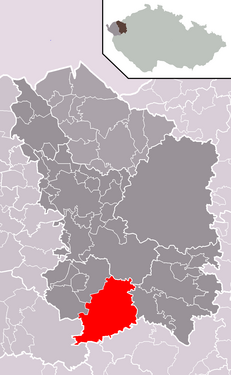
| Location of Toužim in the Karlovy Vary district | ||||
|
||||
Toužim (German Theusing ) is a town in Okres Karlovy Vary in the Czech Republic . The historical center of Toužim has been declared an urban monument reserve.
Geographical location
The city is located in western Bohemia in Teplá Highlands ( Tepelská vrchovina ) to the Schnella ( Střela ), 22 kilometers south of Carlsbad ( Karlovy Vary ).
The city state road 20 / lead E 49 of Bečov nad Teplou ( Petschau ) to Plzen ( Pilsen ) and the railway line from Rakovník ( Rakovník ) to Bečov nad Teplou.
Neighboring towns are Chylice and Krásný Hrad in the north, Kojšovice and Lachovice in the northeast, Radyně and Smilov in the east, Políkno, Komárov and Luhov in the southeast, Třebouň and Kosmová in the south, Poseč in the southwest, Sedlo in the west and Útvina in the northwest.
history

In the second half of the 12th century, the Přemyslids began to settle the border forest to the Nordgau (Bavaria) by the Premonstratensians of the Mühlhausen monastery , who built a provost's office here. Toužim was first mentioned in writing on September 17, 1354, when the Church of St. Bartholomew in Pröles was separated from the provost of Toužim as an independent parish. The parish church of the Nativity of Mary is mentioned as such in 1384.
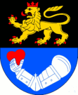
Before the Taborites , who destroyed the monastery in 1420, the convent had fled to Toužim. In 1427 Jakoubek z Vřesovic conquered the area and expelled the order. In 1437 he acquired the monastery property from Emperor Sigismund as hereditary property for his son Jan I of Vřesovice, who had the provost house converted into a castle. The Calixtine Vřesovicer were in permanent feud with the owners of the lordships of Bečov and Buchau , the Catholic lords of Plauen , with the Tauzim castle as the starting point for their raids. After the Plauen troops had destroyed the economic center of the Toužim rule, the town of Utwein, during the time of Jan II of Vřesovice , Georg von Podiebrad allowed the citizens of Utwein to move their place under the Tausim castle and founded the town on July 8, 1469 Toužim, to whom he transferred all privileges including the coat of arms of Utwein and additionally granted the right of fortification. When the political situation in Bohemia began to stabilize again after the death of Georg von Podiebrad, some of the Utwein residents returned to their old town and began to rebuild. Subsequently, a dispute arose between the residents of Útvina and Toužim about town rights, which led to King Vladislav II of the town of Toužim issuing a new coat of arms privilege on January 5, 1478 at the request of Jan II of Vřesovice, so that Útvina did could carry on old coats of arms. The town flourished under the lords of Vřesovice, which benefited from the castle as a noble seat of the Vřesovice family. At that time, 70% of the population of Toužim was Czech.
After 1488 Jindřich von Vřesovice sold the rule to his former hereditary enemy Heinrich III. from Plauen. This gave the king the privilege of holding a second fair in 1500. German settlement began at this time. After the death of Heinrich III. his son Heinrich IV took over the inheritance in 1519. In 1538 Henry IV acquired the Toužim estate as a hereditary property. 1560 which included manorial 32 villages, two towns Toužim and Schönthal and the town Útvina. At the transition from the 16th to the 17th century, the town of Toužim was mostly inhabited by Germans. After 1600, Jews also moved in. After Heinrich V von Plauen died in 1565 without heirs, Heinrich Nikolaus Lobkowicz von Hassenstein inherited the rule. His son Christoph lost his property as a rebel after the battle of the White Mountain and went into exile in Saxony as a Protestant. The rule was acquired in 1623 by the imperial general Julius Heinrich von Sachsen-Lauenburg . After the death of Prince Julius Franz von Sachsen-Lauenburg , his daughter Franziska Sibylla inherited the rule as part of the Schlackenwerther share and brought her goods into the marriage with the Türkenlouis . He was followed by his son August Georg Simpert , with whom the house of Baden-Baden became extinct in 1771 in the male line. His bohemian goods fell by escheat to the Bohemian crown . The Bohemian Queen Maria Theresa and his niece Elisabetha Augusta contractually agreed to use the Bohemian goods for life.
Elisabetha Augusta leased the Toužim manor to her cousin Johann I von Schwarzenberg († 1789) for 15 years in 1783 . After his death, his son Joseph II entered the contract. In 1799 the Toužim rule fell to the Bohemian Chamber . In 1837 Alfred von Beaufort-Spontin bought the estate. He was the last feudal owner before the end of inheritance in 1848. The construction of the imperial road from Pilsen to Elbogen between 1845 and 1848 brought the city an important transport link.
After the abolition of patrimonial rule, the municipality of Theusing was established in the Karlsbad district in 1850 . In 1854 Theusing consisted of 314 houses and had 1979 inhabitants. On December 10th, 1898 the local railway Rakonitz - Petschau - Buchau was inaugurated and Theusing was connected to the railway network. In 1905 the city was assigned to the Teplá district .
After the First World War , Theusing was added to the newly created Czechoslovakia in 1919 . In 1930 Theusing had 1933 inhabitants, 39 of whom were Czech. Due to the Munich Agreement , the city came to the German Reich in 1938 and until 1945 belonged to the district of Tepl , Eger district , in the Reichsgau Sudetenland . In 1939 Theusing had 1957 inhabitants.
During the Second World War , a Reich Labor Service camp was set up in the forest on the road to Tschebon . Towards the end of the war in April 1945 a group of eleven deserted German soldiers was captured by a Wehrmacht commando and members of the SS and hung on trees and power poles along the road from Theusing to Chebon as a public deterrent. American troops occupied the city on May 7, 1945. After the fighting ended, Theusing was taken over by Czechoslovakia in 1945 .
In the following years the expulsion and expropriation of the German population began. A third of the population at that time were refugees from East Prussia , Pomerania and Upper Silesia . The goods of the Counts Beaufort-Spontin were also expropriated in 1945. In the former RAD camp, which was set up for 300 people, a collection camp for Germans was set up in which 2,000 people from Theusing, Uitwa, Sattel, Rading, Koschowitz, Schönburg and Peschkowitz were interned. The Germans were first deported to the American occupation zone and then mostly via Jáchymov ( Sankt Joachimsthal ) and Boží Dar ( Gottesgab ) into the Soviet occupation zone. In May 1946 the camp was closed. Between March 31 and November 11, 1946, the planned mass deportation of the German population of Theusing with 70 kg of luggage took place in several stages, leaving behind all valuables.
Czechs from the Pelhřimov ( Pilgram ) and Písek ( Pisek ) area and then mostly Volhynian Czechs were settled in the city. On January 1, 1946, the city had inhabitants in 2012, on December 31 of the same year there were only 878. In 1949 Toužim was classified as a district town of the Okres Toužim formed from the Okresy Teplá and Žlutice. During this time the town experienced an economic boom and the number of inhabitants doubled to 1642 by 1961. The Toužim district was dissolved again during the territorial reform of 1960 and the town was incorporated into the Karlovy Vary Okres. In 1999 the Trappist monastery Nový Dvůr was founded near Dobrá Voda .
Demographics
| year | Residents | Remarks |
|---|---|---|
| 1785 | k. A. | 234 houses |
| 1830 | 1416 | in 237 houses |
| 1832 | 1400 | in 245 houses |
| 1845 | 1904 | in 318 houses |
| 1854 | 1979 | in 314 houses |
| 1900 | 2130 | German residents |
| 1921 | 2017 | 1981 German residents |
| 1930 | 1933 | including 39 Czechs |
| 1939 | 1957 |
| year | 1970 | 1980 | 1991 | 2001 | 2003 |
|---|---|---|---|---|---|
| Residents | 3594 | 3949 | 3864 | 3798 | 3732 |
City structure
The municipality of Toužim consists of the districts Bezděkov ( Besikau ), Branišov ( Branischau ), Dobrá Voda ( Dobrawod ), Dřevohryzy ( Zeberheisch ), Kojšovice ( Koschowitz ), Komárov ( Kumerau ), Kosmová ( Goßmaul ), Lachovice ( Lachowitz ) Lohof ), Nežichov ( Neschikau ), Políkno ( Poliken ), Prachomety ( Prochomuth ), Radyně ( Rading ), Smilov ( Schmidles ), Toužim ( Theusing ) and Třebouň ( Tschebon ), which also form cadastral districts. Basic settlement units are Bezděkov, Branišov, Dobrá Voda, Dřevohryzy, Kojšovice, Komárov, Kosmová, Lachovice, Luhov, Nežichov, Políkno, Prachomety, Radyně, Smilov, Střed, Toužim-zámek, Toužim-zámek, Třebouň, Uštoužali and Žlutická. The settlement Krásný Hrad ( Schönburg ) also belongs to Toužim .
Attractions
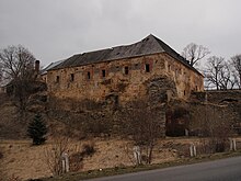
- Toužim Castle. The castle area consists of the Upper Castle , the Lower Castle , the stately brewery and the west wing of the Vorwerkshof. The palace garden was built north of the palace around 1620 and was owned by Duke Heinrich Beaufort-Spontin (1880–1966) until 1945. After the castle had lost its function as an administrative seat at the end of the 18th century, its decline began, which continued in the 19th century when parts of the buildings were demolished.
- The Upper Castle has a Romanesque-Gothic core that goes back to the Premonstratensian provost and was rebuilt in 1437 into the donjon of Tausim Castle. The Gothic castle served as a residence for the Lords of Vřesovice and was converted into a chateau after the fires of 1620 and 1652. From the 19th century, the Upper Palace sank into the Assanierungsflügel.
- The Lower Castle was built around 1544 as a Renaissance building when the Gothic outer bailey was enlarged. Major renovations were carried out between 1576 and 1578, and in 1752 the building was given a Baroque style. In the 19th century the north wing with the adjoining parts of the Upper Castle was demolished.
- The stately brewery was built in 1661 in the palace garden. In 1752 it was demolished and replaced by a new baroque building to the west. The cellars of the old brewery are still preserved.
- City Hall, the formerly Gothic building was redesigned several times after the fires of 1620, 1652, 1752 and 1872 and thus received its present form in the style of Classicism and Empire. In the northern part the vaults of an old black kitchen have been preserved.
- City fountain, from the middle of the 18th century
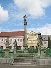
- Plague column depicting Mary with the baby Jesus, from 1705
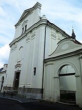
- Parish and deanery church Mariä Wiegenfest, the church including the rectory and the school was built in 1488 during the rule of the Lords of Plauen. Between 1738 and 1742 a baroque redesign was carried out by the master builder Johann Schmied from Útvina. The church was restored in 1774–1778 and 1872 after fires.
sons and daughters of the town
- Josef Antonín Sehling (1710–1756), composer
- Johann Zoph (1740–1812), Field Marshal and Inspector General of the Imperial and Royal Infantry
- Albert Bäuml (1855–1929), innovator of the Nymphenburg porcelain factory
- Wenzel Baier (1869–1956), teacher and local history researcher
- Gustav Doberauer (* 1874), doctor and professor at Charles University in Prague
- Karl Fuchs (1900–1963), sculptor
- Anton Luderer (1895–1978), flautist and music professor in Vienna
Web links
Individual evidence
- ↑ http://www.uir.cz/obec/555657/Touzim
- ↑ Český statistický úřad - The population of the Czech municipalities as of January 1, 2019 (PDF; 7.4 MiB)
- ↑ Památky a příroda Karlovarska: Přílezy - kostel sv. Bartoloměje
- ↑ a b Jaroslaus Schaller : Topography of the Kingdom of Bohemia . Volume 9: Pilsner Kreis , Prague and Vienna 1788, p. 204, item 1) .
- ^ A b Johann Gottfried Sommer : The Kingdom of Bohemia . Volume 15: Elbogner Kreis. Prague 1847, pp. 214-216, paragraph 1) .
- ↑ Yearbooks of the Bohemian Museum of Natural and Regional Studies, History, Art and Literature . Volume 2, Prague 1831, p. 200, paragraph 22.
- ^ Carl E. Rainold: Taschen-Reise-Lexikon für Böhmen . Prague 1833, pp. 582-283 .
- ^ Meyer's Large Conversational Lexicon. 6th edition, Volume 19, Leipzig and Vienna 1909, p. 484 .
- ^ Sudetenland Genealogy Network
- ^ A b Michael Rademacher: German administrative history from the unification of the empire in 1871 to reunification in 1990. Teplá district (Czech Teplá). (Online material for the dissertation, Osnabrück 2006).
- ↑ Czech population statistics
- ↑ http://www.uir.cz/casti-obce-obec/555657/Obec-Touzim
- ↑ http://www.uir.cz/katastralni-uzemi-obec/555657/Obec-Touzim
- ↑ http://www.uir.cz/zsj-obec/555657/Obec-Touzim
