
Wieden (Vienna)
|
Wieden IV. District of Vienna |
|
|---|---|
| coat of arms | map |
 |
 .svg) |
| Geographic location : | 48 ° 12 ′ N , 16 ° 22 ′ E |
| Surface: | 1.8 km² |
| Residents: | 33,212 (January 1, 2020) |
| Population density : | 18,451 inhabitants / km² |
| Postal code : | 1040 |
| Address of the district council: |
Favoritenstrasse 18 1040 Vienna |
| Address of the district office: |
Right Wienzeile 105 1050 Vienna |
| Website: | www.wien.gv.at |
| politics | |
| District Head : | Lea Halbwidl ( SPÖ ) |
|
District council election 2015 |
A total of 40 seats |
The Wieden is the 4th Vienna district , and is within the belt , the place of the former Linienwall was created. The district was created in 1850 through the incorporation of several suburbs, in 1861 it was divided and lost part of its area to the newly created 5th district, Margareten . The Wieden is a typical inner district, a densely populated area with few green spaces. The district name is used with the feminine article, ie "die Wieden" or "auf der Wieden".
geography
_(cropped).jpg)
location
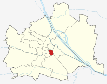
The Wieden is limited as follows:
- North: Inner City (1st district), border: Karlsplatz (along the U4 route ) and Lothringerstraße, southern house front
- East: Landstrasse (3rd district), border: Schwarzenbergplatz and Prinz-Eugen-Strasse
- South: Favoriten (10th district), border: before: northern edge of the Südbahnanlagen (just south of the belt ), since 2009: southern edge of the belt main carriageway
- West: Margareten (5th district), border: Kettenbrückengasse, Margaretenstraße, Kleine Neugasse, Mittersteig, Ziegelofengasse, Blechturmgasse to the Gürtel
- North-west: Mariahilf (6th district), border: right Wienzeile , northern sidewalk edge to Naschmarkt
The 4th district is crossed from northeast to southwest by Wiedner Hauptstrasse and from north to south by Favoritenstrasse . Since a border change in 2009, no part of the Naschmarkt belongs to the 4th district.
use
The construction area of the Wieden is 67.4% (Vienna-wide 33.32%), with around 77.9% being in residential areas. At approx. 26%, the traffic area takes up the second largest share of the district area (Vienna-wide 13.75%). The green spaces only take up 6.56% of the district area (Vienna-wide 48.26%), with 85.5% being used for parks. However, five other districts have even less green space than the Wieden. Forests, allotment gardens, sports or leisure areas and areas used for agriculture are not available on the Wieden.
| Construction area | Green space | Waters | Traffic areas | |||||||
|---|---|---|---|---|---|---|---|---|---|---|
| 121.07 | 17.7 | 0 | 45.4 | |||||||
| Housing | Service area | public facilities | Agriculture | Parks | Woods | grasslands | Allotments | Leisure areas | ||
| 94.29 | 6.07 | 12.8 | 0 | 12.1 | 0 | 0 | 0 | 5.6 | ||
District parts

The district parts of the Wieden are Wieden , the eastern part of Hungelbrunn and the Schaumburgergrund . They go back to formerly independent localities, but are of no importance in political administration.
A division of the district area exists today in the counting districts of the official statistics, in which the counting areas of the municipality are summarized. The four counting districts on the Wieden are Technische Hochschule, Argentinierstraße, Wiedner Hauptstraße and Schaumburgergrund. The borders of the census district Schaumburgergrund are not identical to those of the formerly independent village of the same name.
history


The Wieden was first mentioned in 1137, making it one of the earliest mentioned suburbs of Vienna. The name comes from Widem, Widum 'Pfarrhof, -gut', originally as a property donated (dedicated) to a parish. The main street ( Wiedner Hauptstraße ) is certainly even older. Under Ferdinand II , the imperial summer residence, called Neue Favorita , to the east of this main street , was completed and subsequently enlarged several times.
In 1737 one of the most important sacred buildings in Austria was completed in what is now the district, the Karlskirche , which was built according to imperial vows . It stood on the southern bank of the then completely unregulated Vienna River and was optically aligned with the Hofburg , the Viennese imperial residence in today's old town. The square surrounding the church has been named after the founder, Emperor Karl VI. , Called Karlsplatz .
A little later, his daughter Maria Theresa decided not to use the Neue Favorita any more and to sell it to the Jesuits . They turned the summer residence into an educational institution, which in later decades developed into the private and now highly regarded Theresianum grammar school . (Austria's Diplomatic Academy is also located here.)
The road, which led uphill to the south on the main front of the Neue Favorita, met there since 1704 a new fortification, the line wall , with a guarded gate, called the "favor line". Outside the gate, the “settlement in front of the favorites line” developed, which until 1874 belonged to Wieden (and from 1861 also to Margareten). The road there was consequently called Favoritenstraße and is still called that in the 4th and 10th districts.
At the beginning of the 18th century, the Wieden began to develop into a suburb. Among other things, many aristocratic palaces were built. Two small suburbs in what is now the 4th district were Hungelbrunn (partly in the 5th district since 1861) and the Schaumburgergrund , which was only created in 1813.
These three suburbs, along with a number of others, were incorporated into Vienna on March 6, 1850 under the district name Wieden as the 4th district. Because of the social and economic differences, the less affluent part of the district, further away from the center, was separated from the 4th district as the new 5th district, Margareten . At that time, the Wieden and now Margareten were the only districts outside, south of the line wall; these were separated as the new 10th district, Favoriten , in 1874 .
In 1854 the Elisabethbrücke was built over the Wien River at a point where the first bridge was mentioned in 1211 to connect the Wiedner Hauptstraße with the old town , named after Elisabeth of Austria , the wife of Emperor Franz Joseph I ; the couple married that same year.
1895-1900 the regulation of the river Wien took place in the entire city area. In the area of today's Naschmarkt (which moved to this location from 1902) and the area known as Karlsplatz since 1899, the river was completely vaulted in sections; the bridge statues erected in 1867 on the Elisabeth Bridge, which was dismantled in 1897, moved to Rathausplatz . At the same time the Vienna steam light rail was built; their station Karlsplatz , in operation since 1899. It was first replaced by the Vienna Electric Light Rail in 1925 and is now an underground junction (lines U1, U2, U4).
Many residential buildings were built during the founding period , but the so-called Freihaus had been located here since around 1700 , at that time the largest apartment building (rental building) in Vienna. It was gradually removed until 1970.
The belt as a bypass road for the new districts 3 to 9 was created in sections. In 1880 the southern belt was only available as a project, in 1882 the name Wiedner Gürtel was established. After numerous suburbs of the city in the north-west, west and south-west were incorporated on January 1, 1892, the obsolete line wall was removed in the nineties of the 19th century (a small remnant of the wall has been preserved in the courtyard of the house at 13 Weyringergasse). Now the Wiedner Belt could be laid out broadly and built on its northern edge. (The southern runway stretched along the southern edge .)
In 1910, the Goldegg coffee house was founded on Argentinierstraße at the corner of Goldegggasse.
In the interwar period, the “Funkhaus” was built for RAVAG (today: ORF) on Argentinierstrasse, and live radio programs are still broadcast from its broadcasting hall. (The ORF wants to sell the building, however.) During the attempted National Socialist putsch, the radio station was temporarily occupied by the insurgents on July 25, 1934. In the years of occupation (1945 to 1955) the Wieden was part of the Soviet sector of Vienna, because the "Russians" wanted the transmitters within their sphere of influence.
The St. Josef Children's Hospital was destroyed during the Second World War . The Wiedner Hospital was demolished and the Bertha-von-Suttner-Hof was rebuilt in its place. In 1954–1959, the Historical Museum of the City of Vienna (today: Wien Museum ) was built next to the Karlskirche on Karlsplatz . In 1957 the building of the Chamber for Workers and Salaried Employees was built on the grounds of the former Palais Rothschild at Prinz-Eugen-Straße 20-22 . The official building for the 4th district was rebuilt in 1969 at 18 Favoritenstraße . With the opening of the U1 in 1978, the Resselpark and Karlsplatz were redesigned with a new pond in front of the Karlskirche.
The Vienna University of Technology got a new institute building and a library between Wiedner Hauptstrasse and Operngasse .
The Akzent Theater was opened in 1989. In 1995 the district museum and the chimney sweep museum opened in the former public bath at Klagbaumgasse 4. In 1999 there was a slight change in the district boundaries, with the boundary between Schwarzenbergplatz and Prinz-Eugen-Straße and the 3rd district and in the area of Kettenbrückengasse the border to the 5th district was moved.
The final version of the Kunsthalle Karlsplatz was built around 2001 . In 2009, the district boundary in the area of the Naschmarkt was changed so that the part on the Wieden was assigned to the 6th district.
population
Population development
Source: Statistics.at

Population development
In 1869, 55,682 people lived in the district. In the following years until 1910 the population rose to almost 63,000. By 2001, the resident population had decreased to 28,357. In recent years the Wieden has followed the Viennese trend and the population rose to 31,597 at the beginning of 2015.
Population structure
The proportion of people aged 60 and over is above average at 24.3%, as this proportion is 22.2% in the entire city of Vienna. The proportion of the population under the age of 15 was 12.1%. At 54.1%, the proportion of the female population is also above the average in Vienna.
Origin and language
The proportion of people from Wiedner who were foreign nationals in 2001 was 15.3%, around 2% below the average in Vienna. 3.7% of Wiedner citizens were citizens of Serbia or Montenegro , 1.5% are German citizens. They are followed by other EU citizens (1.8%), Turkish (1.0%), Croats (1.0%) and Bosniaks, as well as other foreigners whose share of the population is less than 1%. In 2001, around 25.4% of the Wiedner population was born in another country, which is why only 76% of the Wiedner people said German as a colloquial language. Another 5.4% spoke mainly Serbian , 2.2% Turkish , 2% Croatian and 1.4% Hungarian .
Creed
The proportion of people with a Roman Catholic faith is 48.1%. The area of the district belongs to the parish of the good news , which belongs to the city dean's office 4/5 . Proportionally behind the people with a Roman Catholic faith, 6.7% follow with Protestant faith (this is the second highest value that Wieden shares with Liesing). and 6.0% with an Orthodox creed. The followers of Islam are in fourth place with 4.6%. 26.3% of the people of Wiedner state that they have no religious beliefs.
politics
| District leaders since 1945 | |
|---|---|
| Herbert Prix (unknown) | 4 / 1945-5 / 1945 |
| Gottfried Albrecht ( SPÖ ) | 5 / 1945-1946 |
| Franz Stöger ( ÖVP ) | 1946-1952 |
| Franz Ramel ( ÖVP ) | 1952-1969 |
| Herbert Walkersdorfer ( ÖVP ) | 1969-1973 |
| Herta Haider ( ÖVP ) | 1973-1987 |
| Karl Lengheimer ( ÖVP ) | 1987-1997 |
| Susanne Emmerling ( ÖVP ) | 1997-2001 |
| Susanne Reichard ( ÖVP ) | 2001-2010 |
| Leopold Plasch ( SPÖ ) | 2010-2018 |
| Lea Halbwidl ( SPÖ ) | 2018– |
The Wieden district was traditionally a bourgeois district. Since the Second World War, the ÖVP has consistently been the party with the strongest vote since 1946 and has been the district chairman for over 50 years. Behind them were traditionally the SPÖ and the FPÖ , which were able to increase their share of the vote in Vienna sharply from the end of the 1980s. When the Greens entered politics in the 1980s, the ÖVP and SPÖ increasingly lost votes. When the Liberal Forum (LIF) started in 1996 , it was again at the expense of the ÖVP and the SPÖ. While the FPÖ and the LIF lost votes again from 2001, the Greens continued to gain votes. In 2005, the ÖVP was only just ahead of the SPÖ, which was able to significantly reduce the gap to the ÖVP. The Greens ended up just behind in third place with a plus of around 6%. In the state and municipal council elections in Vienna in 2010 , the SPÖ was just a few votes ahead of the Greens and the ÖVP, which overall did very poorly in these elections and fell back to third place.
coat of arms
The coat of arms of the Wieden district is made up of the coats of arms of three former Viennese suburbs, which were wholly or partly in the current district area. The upper right part stands for the Wieden district and shows a willow tree . This coat of arms was created due to a misinterpretation of the name Wieden, which is not derived from the willow tree, but from the term " Widum " (parsonage / parish). Top left is dedicated to the Schaumburgergrund district . Here the Stephansturm is shown, surrounded by the Starhemberg count's crown. This stands for the defense of Vienna in 1683 by Ernst Rüdiger von Starhemberg , who owned the Freihaus on the Wieden . The lower part of the coat of arms finally shows the coat of arms of the suburb Hungelbrunn , a small part of which is in today's 4th district. It shows a draw well above which Saint Leopold , patron saint of Lower Austria , hovers. Next to them are Saint Peter and Saint Florian , to whom the neighboring Florian Church in Matzleinsdorf is consecrated.
Culture and sights
Attractions
.JPG)
- Hay mill
- Karlskirche
- Naschmarkt
- Paulan Church
- Karlsplatz tram station (Otto Wagner Pavilion)
- Theresianum
- Vienna Museum
- Schönburg Palace
- Mozart fountain
- Alois Drasche Park
- Elisabeth Church in Wiedener
- ORF broadcasting house
Culture
Most of the Wieden belongs to the World Heritage Site of the Historic Center of Vienna . Its outer zone is bordered to the south by Kolschitzkygasse and Weyringergasse and to the west by Klagbaumgasse and Schönburgstrasse. The Karlsplatz with the Karlskirche, the Wien Museum, the main building of the Technical University and the Evangelical School is part of the core zone of the World Heritage site.
Museums
The most visited museum in the Wieden district is the Wien Museum Karlsplatz, which documents the history of Vienna over the centuries in its exhibition and has an art collection and a historical collection. The Wien Museum also includes Schubert's dying apartment in Kettenbrückengasse, where the composer's last phase of life is shown. Much more extensive documentation about Franz Schubert can be found in the house where he was born on Alsergrund (9th district), Nussdorfer Straße.
The Generali Foundation's collection has a collection of around 2,100 contemporary works by around 170 international artists. The oldest works of art are from the 1950s.
The Kunsthalle Wien , which dates back to a temporary facility on Karlsplatz, still has a location at this location today; their main domicile is in the Museumsquartier Vienna . Furthermore, in the district of Wieden from 1967-2013 there was the Funeral Museum of Bestattung Wien , which is now located at the Central Cemetery.
The chimney sweep museum and the private third man museum can also be found in the 4th district. The Wieden District Museum focuses, among other things, on the documentation of the Freihaus auf der Wieden , the Wiedner Mühlfeld, the Linienwall and old, abandoned Wiedner businesses.
Economy and Infrastructure
District Representation, District Office
The political organs of the district, the district council and the district council, are in office in the municipal office building 4., Favoritenstraße 18. The district office responsible for the Wieden for the 4th and 5th district is in Vienna 5th, rights Wienzeile 105.
traffic
Private transport
The district is bounded in the north ( Wienzeile ), in the south and west ( Gürtel ) by important main roads. Wiedner Hauptstrasse and Favoritenstrasse run right through the district. In addition, Südtiroler Platz is also an important traffic junction. In total, Wieden has almost 29 km of local roads (2008).
The bicycle traffic facilities in the district cover approx. 8.9 km (2008) and thus form a close-knit network. In the district (as in the other inner-city districts), cycling is playing an increasingly important role in individual transport, as it is possible to ride a bicycle against some one-way lanes. However, there are still many gaps in the cycle network. In addition, the Wieden has several city bike stations, which are distributed over the entire district. Further stations are located near the district border.
Public transport
The public transport is used by the Wiener Linien settled. The 4th district has three stations of the U1 ( Karlsplatz to Südtiroler Platz ), and there are stations of the U2 and U4 at the district border . In addition, Vienna's main train station, completed in 2015, and the main S-Bahn line are located in the 10th district on the border with the 4th district.
The tram lines 1 and 62 and the Badner Bahn run through Wieden on Wiedner Hauptstrasse and line D through Prinz-Eugen-Strasse. In addition to the tram, there are also two bus routes (13A and 59A).
During the night, Wieden is served by four NightLine bus routes (N60, N62, N66 and N71). Three of them are in operation daily between around 0:30 a.m. and around 5:00 a.m., the fourth line only on weekends.
The Südtirolerplatz lies mostly in the 4th district and is a great traffic and Umsteigeknotenpunkt in the south, as urban and regional bus lines, night bus, tram, metro and suburban rail lines move to this place. Most of the stop names there were changed to Hauptbahnhof in 2012 .
education
There are six elementary schools , three secondary schools , three grammar schools , a higher technical college as evening school, a music conservatory , the university of applied sciences course for finance and controlling at the Vienna University of Applied Sciences and the Vienna University of Technology .
Particularly noteworthy are the branch of the Wiedner Gymnasium with the aim of promoting the gifted ( Sir Karl Popper School ) and the well-known "Nobel" gymnasium Theresianum . A training option of Wiener community college is the polycollege Wiedenmann , a branch of the polycollege in Margaret .
safety
Only one police station of the Federal Police is established on the Wieden , this is located in Taubstummengasse 11. Organizationally, it belongs to the Margareten City Police Command, which is responsible for the districts of Wieden, Margareten and Mariahilf.
Personalities
- Johannes Brahms (1833–1897), composer, pianist and conductor
- Christoph Willibald Gluck (1714–1787), composer
- Ferdinand Bloch-Bauer (1864–1945), sugar manufacturer and art lover
- Anton Burg (1767–1849), agricultural toolmaker and machine manufacturer
- Karl Kraus (1874–1936), writer
- Karl Lueger (1844–1910), politician
- Rosa Mayreder (1858–1938), writer, women's rights activist, cultural philosopher, librettist, musician and painter
- Emanuel Schikaneder (1751–1812), actor, singer, director, poet and theater director
- Matthias Paulus Steindl (1761–1828), Roman Catholic bishop
- Johann Strauss (son) (1825–1899), conductor and composer
See also
Movies
- My Wieden ; Documentation by Chico Klein, Austria 2015
literature
- Felix Czeike: Viennese district culture guide: IV. Wieden . Jugend und Volk, Vienna 1979, ISBN 3-7141-0469-0
- Felix F. Czeipek: Vienna - Wieden: historical district pictures . Sutton, Erfurt 2004, ISBN 3-89702-715-1
- Peter Diem, Michael Göbl, Eva Saibel: The Viennese districts. Your story - your personalities - your coat of arms . Deuticke Verlag, Vienna 2003, ISBN 3-85223-463-8
- Carola Leitner (Ed.): Wieden: Vienna's 4th district in old photographs , Ueberreuter, Vienna 2007, ISBN 978-3-8000-7307-8
Web links
Individual evidence
- ↑ Statistics Austria - Population at the beginning of 2002–2020 by municipalities (area status 01/01/2020)
- ↑ District council elections 2015
- ↑ Provincial Law Gazette for Vienna (LGBl. No. 47/2009). (PDF; 309 kB) Law on changing the border between the 1st and 4th district. In: City of Vienna. September 28, 2009 .
- ↑ The new main train station does not stop at district borders. In: City Hall correspondence of the City of Vienna. March 2, 2009, accessed May 15, 2020 .
- ↑ Provincial Law Gazette for Vienna (LGBl. No. 48/2009). (PDF; 617 kB) Law on changing the boundaries between the 4th and 10th district and the 3rd and 10th district. In: City of Vienna. September 28, 2009 .
- ↑ Provincial Law Gazette for Vienna (LGBl. No. 46/2009). (PDF; 385.3 kB) Law on changing the border between the 4th and 6th district. In: City of Vienna. September 28, 2009 .
- ↑ a b City area according to usage classes and districts 2018. In: City of Vienna ( MA 18 ). Retrieved May 15, 2020 .
- ↑ a b Green spaces according to usage classes and districts 2018. In: City of Vienna (MA 18). Retrieved May 15, 2020 .
- ↑ and not from willows (trees), Wied 'Au'. According to Heinz-Dieter Pohl, Birgit Schwaner: The book of Austrian names - origin, peculiarity, meaning. ISBN 978-3-85431-442-4 (according to the extract given on the author's website Did you know ... , 1st point)
- ↑ Law on changes to the boundaries between the 3rd, 4th and 5th district , LGBl. For Vienna No. 13/1999, issued on February 5, 1999
- ↑ Census of May 15, 2001. Final resident population and number of citizens (with population development since 1869). District of Vienna: Vienna 4th, Wieden , on Statistics.at (PDF, 12 kB).
- ↑ a b c 2001 census (PDF; 10 kB)
- ↑ Josef Taucher (SPÖ) congratulates Lea Halbwidl, the new district chairwoman of Wiedner . OTS announcement of October 23, 2018, accessed October 23, 2018.
- ^ Wieden district representative elections 2010 Magistratsabteilung 62, Vienna
- ↑ MA 23, MA 28 : Municipal roads by municipal districts 2018. In: wien.gv.at. Retrieved June 6, 2020 .
- ↑ MA 23, MA 28: Traffic areas and bicycle traffic facilities by districts 2018. In: wien.gv.at. Retrieved June 6, 2020 .
- ↑ Meine Wieden orf.at, accessed on July 14, 2015
1., Inner City | 2., Leopoldstadt | 3rd, highway | 4., Wieden | 5th, Margareten | 6., Mariahilf | 7., new building | 8., Josefstadt | 9., Alsergrund | 10., Favorites | 11., Simmering | 12., Meidling | 13., Hietzing | 14., Penzing | 15., Rudolfsheim-Fünfhaus | 16., Ottakring | 17th, Hernals | 18., Währing | 19., Döbling | 20th, Brigittenau | 21., Floridsdorf | 22., Donaustadt | 23rd, Liesing