
Rocca di Papa
Rocca di Papa | |
|---|---|
| Comune di Rocca di Papa | |
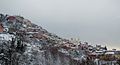
 View of Rocca di Papa. | |
Location of Rocca di Papa  | |
 Rocca di Papa Location of Rocca di Papa in Italy  Rocca di Papa Rocca di Papa (Lazio) | |
| Coordinates: 41°45′40″N 12°42′33″E / 41.76111°N 12.70917°E | |
| Country | Italy |
| Region | Lazio |
| Province | Rome |
| Government | |
| • Mayor | Pasquale Boccia (since May 2006) |
| Area | |
| • Total | 40 km2 (20 sq mi) |
| Elevation | 680 m (2,230 ft) |
| Population | |
| • Total | 12,714 |
| • Density | 320/km2 (820/sq mi) |
| Demonym | Roccheggiani |
| Time zone | UTC+1 (CET) |
| • Summer (DST) | UTC+2 (CEST) |
| Postal code | 00040 |
| Dialing code | 06 |
| Patron saint | St. Charles Borromeo |
| Saint day | november 4 |
| Website | www.comune.roccadipapa.rm.it |
Rocca di Papa is a small town and comune in the province of Rome, Lazio, Italy. It is one of the Castelli Romani about 25 km south east of Rome on the Alban Hills. It is bounded by other communes, Velletri, Rocca Priora, Monte Compatri, Grottaferrata, Albano and Marino, Italy. It is the centre of the Regional Park know as the "Parco Regionale dei Castelli Romani".
History
Documents from 12th century name Rocca di Papa as "Castrum Rocce de Papa" (Rock Castle of the Pope), because here lived Pope Eugene III.
In 1541 Pier Luigi Farnese, with French troops, destroyed the castle.
In 1855 the people proclaimed the "Rocca di Papa Republic" against the prince Colonna and Papal States government.
In 1889 the "Royal Geodynamic Observatory" was built on the top of Rocca di Papa, near the little Church of Crucified. In this built from 1922 to 1935 the scientist Guglielmo Marconi did several experiments about the radio-transmissions, wireless transmissions and broadcast.

In 1944, during World War II, Rocca di Papa was bombed. Central part of the city was destroyed. Thirty four people died in that air strike and 35 died in a second air strike on May 25. The city was liberated from the Nazi German occupation on June 4, 1944 by the 85th Infantry Division.
The funicular
In 1906 the funicular of Rocca di Papa was inaugurated: it connected “Valle Oscura” to avenue "Silvio Spaventa" and it worked thanks to a system of communicating large cases, with the movement furnished by the counterweights of the same ones moved by the water every time, regulated according to the number of passengers.
Dismantled the preceding one, July 28th 1932 the electric funicular was inaugurated on June 28 1932, connecting the station of “Valle Vergine” with Margherita Square; it remained in service until to 1962.
Main sights
- Santuario Madonna del Tufo
- Chiesa del Crocefisso
- Duomo dell'Assunta (principal church)
- Fontana della Barcaccia
- Quartiere dei Bavaresi, built by Bavarian militiamen left here by Emperor Louis IV in 1328.
- Via Sacra (The Sacret Way of Monte Cavo).
- Convent of Palazzola
Federal Equestrian Centre of C.O.N.I. in Vivaro
From 1960 was installed in Vivaro green area, the equipment for the horse-riding events of the Olympic Games. The equipment has been improved and enlarged to form an adequate spot for the preparation of the best italian and international horse-riders, offering an excellent track with every kind of difficulty and obstacle. All kinds of Equestrianism are possible in Vivaro centre: Show jumping and Cross-country equestrianism.
Festival
- Chestnut Festival: 3rd Sunday, October
- Roast Chestnut Festival: 3rd week-end of November
It is possible to eat the roast chestnut (the "Rocchicianelle") with new wines of Castelli Romani pouring out by stands in the streets of Rocca di Papa.
Geophysical Museum
The Geophysical Museum illustrates the idea and the scientific data that have brought to the modeling of the inside of the Earth, preserve tools and scientific documents of the geology, geography and terrestrial physics, sciences that have contributed to the knowledge of the inside of the Earth.
The Convent of Palazzola

The Convent of Palazzola is on top of a rock dominating the east shore of Lake Albano. The old roman buildings was transformed into monasteries and church dedicated to St Mary of Palatiolo. In this strategic position some archaeologists placed the site of Albalonga. In the orchard of the convent there is a sepulchral monument of the 2nd century B.C. with a graded pyramid. Now the ancient Abbey with the artistic church belongs to the English College.
The astronomic observatory "Franco Fuligni"
The astronomic observatory "Franco Fuligni" site precisely in the fraction Vivaro (near the Federal Equestrian Center of C.O.N.I.) is a public structure, available for whoever (skygazings, curious, Amateur astronomers, groups and students) was interested to discover the beauties of the universe. The geographical coordinates are: Latitude: 41º 44' 58" N Longitude: 12º 46' 13" - Altitude: 550 m
Famous citizens and residents
- Massimo Taparelli (1798 - 1866) the Marquis d'Azeglio, Italian statesman, novelist and painter
- Theodore William Achtermann (1799 - 1884) sculptor
- Luise Rinser (1911 - 2002) writer
- Domenico Tojetti (Rocca di Papa 1807 - San Francisco 1892) painter
Twin cities
External links
- Official site Geophysical Museum
- Official site Astronomic observatory
- Official site of Palazzola-Venerable English College
Photo gallery
-
 A view of the town
 -
 Panorama view
 -
 Graffiti
 -
 Panorama view from Via Roma
 -
 Civic center
 -
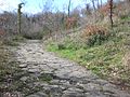 Sacret Way on Monte Cavo


- ^ "Superficie di Comuni Province e Regioni italiane al 9 ottobre 2011". Italian National Institute of Statistics. Retrieved 16 March 2019.
- ^ "Popolazione Residente al 1° Gennaio 2018". Italian National Institute of Statistics. Retrieved 16 March 2019.