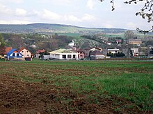
Šarišské Bohdanovce
| Šarišské Bohdanovce | ||
|---|---|---|
| coat of arms | map | |

|
|
|
| Basic data | ||
| State : | Slovakia | |
| Kraj : | Prešovský kraj | |
| Okres : | Prešov | |
| Region : | Šariš | |
| Area : | 9.360 km² | |
| Residents : | 921 (Dec. 31, 2019) | |
| Population density : | 98 inhabitants per km² | |
| Height : | 225 m nm | |
| Postal code : | 082 05 | |
| Telephone code : | 0 51 | |
| Geographic location : | 48 ° 51 ' N , 21 ° 19' E | |
| License plate : | PO | |
| Kód obce : | 525201 | |
| structure | ||
| Community type : | local community | |
| Administration (as of November 2018) | ||
| Mayor : | Peter Merkovský | |
| Address: | Obecný úrad Šarišské Bohdanovce č. 87 082 05 Šarišské Bohdanovce |
|
| Website: | www.sarisskebohdanovce.sk | |
| Statistics information on statistics.sk | ||
Šarišské Bohdanovce (until 1948 Slovak "Bogdanovce"; Hungarian Sárosbogdány - until 1907 Bogdány ) is a municipality in the east of Slovakia , with 921 inhabitants (December 31, 2019) in Prešov District , part of the Prešovský kraj and becomes the traditional landscape Šariš counted .
geography
The municipality is located in the central part of the Košická kotlina basin on the left bank of the Torysa . The center of the village lies at an altitude of 225 m nm and is 20 kilometers from Košice and 22 kilometers from Prešov .
history
The place was first mentioned in writing in 1299. In 1828 there are 75 houses and 561 inhabitants.
population
Results of the 2001 census (663 inhabitants):
|
By ethnicity:
|
By denomination:
|
Attractions
- Roman Catholic Church from 1768, expanded in 1925
- Memorial to the fallen of the First World War and to the Czechoslovak statehood
- Country castle with a park from the 19th century
Web links
Commons : Šarišské Bohdanovce - collection of pictures, videos and audio files
- Entry on e-obce.sk (Slovak)


