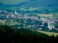
Hrabkov
| Hrabkov | ||
|---|---|---|
| coat of arms | map | |

|
|
|
| Basic data | ||
| State : | Slovakia | |
| Kraj : | Prešovský kraj | |
| Okres : | Prešov | |
| Region : | Šariš | |
| Area : | 16.846 km² | |
| Residents : | 686 (Dec. 31, 2019) | |
| Population density : | 41 inhabitants per km² | |
| Height : | 452 m nm | |
| Postal code : | 082 33 ( Chminianska Nová Ves post office ) | |
| Telephone code : | 0 51 | |
| Geographic location : | 48 ° 58 ' N , 21 ° 1' E | |
| License plate : | PO | |
| Kód obce : | 524476 | |
| structure | ||
| Community type : | local community | |
| Administration (as of November 2018) | ||
| Mayor : | Jaroslav Hovančák | |
| Address: | Obecný úrad Hrabkov č. 81 082 33 Chminianska Nová Ves |
|
| Website: | www.hrabkov.ocu.sk | |
| Statistics information on statistics.sk | ||
Hrabkov (Hungarian Harapkó - until 1907 Hrabko ) is a municipality in the east of Slovakia with 686 inhabitants (December 31, 2019) in Prešov District , part of the kraj Prešovský , and is the traditional landscape Šariš counted.
geography
The municipality is located in the southwestern part of the Šarišská vrchovina mountain range in the source area of the Krížovanka brook . The Hrabkovské zlepence nature reserve (literally Hrabkov conglomerates ) can be found south of the built-up area . The center of the village lies at an altitude of 452 m nm and is 21 kilometers away from Prešov .
Neighboring municipalities are Chminianske Jakubovany in the north, Krížovany in the northeast, Žipov in the east, Klenov in the south, Kluknava in the southwest and Ovčie in the west.
history
Hrabkov was first mentioned in writing as Crapcko in 1330 . A pastor named Sigfrid worked in the local church in 1332 and a few years later. In 1334 the Augustinian order was invited here and a monastery was built, the monks also received the local goods. The rule of the monastery only lasted until 1351, after which the village was owned by the local landlords. In 1427, 42 portals were listed in a tax register . Later the free farmers became impoverished or emigrated, so that in 1543 only seven portals were due and in 1600 the village consisted of 37 subjects' houses, a church and a parish, possibly also a mill and a school. The Augustinians were active until the beginning of the Reformation, after which the monastery fell into disrepair and was demolished.
In 1787 the village had 65 houses and 547 inhabitants, in 1828 there were 73 houses and 542 inhabitants who were employed as woodcutters, farmers, lime burners and charcoal burners.
Until 1918/1919, the place in Sáros County belonged to the Kingdom of Hungary and then to Czechoslovakia or now Slovakia. In the first Czechoslovak Republic, agriculture and forest work were the main sources of income for the population. After the Second World War, part of the population worked in industrial plants in cities such as Prešov, Košice and Krompachy .
population
According to the 2011 census, 700 inhabitants lived in Hrabkov, including 685 Slovaks and one Russian . 14 residents did not provide any information on ethnicity .
669 residents supported the Roman Catholic Church, four residents the Greek Catholic Church and one resident of the Evangelical Church AB. Five residents were non-denominational and the denomination of 21 residents was not determined.
Buildings and monuments
- Roman Catholic Church of Simon and Jude probably from the 14th century. The originally Gothic church was changed to Baroque style in 1716 and expanded in 1843
Culture
The Hrabkovčan folklore ensemble is based in Hrabkov .
Individual evidence
- ↑ Slovenské slovníky: názvy obcí Slovenskej republiky (Majtán 1998)
- ↑ Results of the 2011 census (Slovak)
Web links
- Entry on e-obce.sk (Slovak)


