Fričovce
| Fričovce | ||
|---|---|---|
| coat of arms | map | |

|
|
|
| Basic data | ||
| State : | Slovakia | |
| Kraj : | Prešovský kraj | |
| Okres : | Prešov | |
| Region : | Šariš | |
| Area : | 8.570 km² | |
| Residents : | 1,152 (Dec 31, 2019) | |
| Population density : | 134 inhabitants per km² | |
| Height : | 452 m nm | |
| Postal code : | 082 37 ( Široké post office ) | |
| Telephone code : | 0 51 | |
| Geographic location : | 49 ° 1 ′ N , 20 ° 58 ′ E | |
| License plate : | PO | |
| Kód obce : | 524409 | |
| structure | ||
| Community type : | local community | |
| Administration (as of November 2018) | ||
| Mayor : | Jan Mikula | |
| Address: | Obecný úrad Fričovce č. 34 082 37 Fričovce |
|
| Statistics information on statistics.sk | ||
Fričovce (German Friedrichsdorf , Hungarian Frics ) is a place and a municipality in eastern Slovakia , with 1152 inhabitants (as of December 31, 2019). It is located in the Okres Prešov , part of the Prešovský kraj .
geography
The municipality is located in the Šarišská vrchovina mountains on the Svinka river , east of the Branisko mountain range , 22 kilometers west of Prešov .
history
The place was founded around 1300 and is mentioned for the first time in 1320. In 1828 there are 73 houses and 540 inhabitants.
Attractions
- Roman Catholic Bartholomew Church from 1734
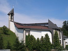
- Roman Catholic Church of the Košice Martyrs from 1994
- Renaissance country castle from 1630
Web links
Commons : Fričovce - collection of images, videos and audio files


