
Barnstorf
| coat of arms | Germany map | |
|---|---|---|

|
Coordinates: 52 ° 43 ' N , 8 ° 31' E |
|
| Basic data | ||
| State : | Lower Saxony | |
| County : | Diepholz | |
| Joint municipality : | Barnstorf | |
| Height : | 29 m above sea level NHN | |
| Area : | 52.29 km 2 | |
| Residents: | 6465 (Dec. 31, 2019) | |
| Population density : | 124 inhabitants per km 2 | |
| Postcodes : | 49406, 49457 | |
| Area code : | 05442 | |
| License plate : | DH, SY | |
| Community key : | 03 2 51 005 | |
| LOCODE : | DE BAF | |
| Association administration address: | Am Markt 4 49406 Barnstorf |
|
| Website : | ||
| Mayoress : | Elke Oelmann ( Greens ) | |
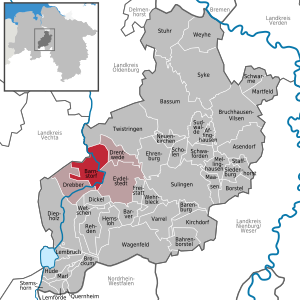
| Location of the municipality of Barnstorf in the district of Diepholz | ||
  |
||

Barnstorf ( Low German : Baarnstrup ) is a market town and the administrative seat in the municipality of the same name in the Diepholz district in Lower Saxony .
geography
Geographical location
Barnstorf is located between the Dümmer Nature Park and the Wildeshauser Geest Nature Park , roughly in the middle of Bremen and Osnabrück . To the west of the village is the Great Moor . The Hunte flows through the village.
Community structure
The area of Barnstorf is divided into Aldorf, Dreeke / Mäkel and Rechtern. The localities Drebber , Eydelstedt and Drentwede with a total of 12,047 inhabitants belong to the political integrated municipality of Barnstorf (as of December 31, 2018).

climate
There is a moderate maritime climate, influenced by humid north-westerly winds from the North Sea. On a long-term average, the air temperature in Barnstorf reaches 8.5–9.0 ° C and around 700 mm of precipitation falls. Between May and August, an average of 20-25 summer days (climatological term for days on which the maximum temperature exceeds 25 ° C) can be expected.
history
Archaeological finds show that the area around Barnstorf has been inhabited since the Neolithic Age. The passage grave of Düsten was moved here. After Charlemagne built nine mission districts from 780 AD to Christianize the conquered Saxons , Abbot Gerbert Castus founded the first parishes in the area from the Visbek mission cell . These counted in Lerigau the parish Barnstorf.
Barnstorf was first mentioned in documents in 890. Because of the border neighborhood between the dioceses of Osnabrück and Münster , the place was the scene of the feuds several times. Barnstorf was part of the County of Diepholz from the 15th century , but later came to the Dukes of Braunschweig . Barnstorf received the land rights from the Counts of Diepholz around 1550. After the Diepholz line of the counts died out in 1585, the rights to the land were confirmed in 1592 by Duke Ernst von Braunschweig-Lüneburg.
After the French occupation, the village and the surrounding hamlets came to the Kingdom of Hanover . The village was connected to the Bremen - Osnabrück railway line in 1872 . In 1952 the first oil and natural gas wells were carried out by Wintershall AG . In 1964, the stationed army here, the air defense missile battalion 25 that was pulled off of 2005. Barnstorf has been the seat of the integrated community of Barnstorf since 1974.
Incorporations
On March 1, 1974, the communities Aldorf, Dreeke and Rechtern were incorporated.
politics
Local council / stain council
The Barnstorf Community Council consists of 19 councilors. This is the specified number for the member municipality of an integrated municipality with a population between 6,000 and 7,000 inhabitants. The nineteen council members are elected by local elections for five years each. The current term of office began on November 1, 2016 and ends on October 31, 2021.
The last local election on September 11, 2016 resulted in the following:
| Political party | Proportional votes | Number of seats |
|---|---|---|
| CDU | 23.70% | 5 |
| SPD | 26.71% | 5 |
| WGB | 16.18% | 3 |
| Alliance 90 / The Greens | 17.48% | 3 |
| FDP | 14.72% | 3 |
| Fuhs single applicant | 1.18% | 0 |
The turnout in the 2016 local elections was 51.99%, below the Lower Saxony average of 55.5%.
mayor
The council elected council member Elke Oelmann (Greens) as honorary mayor for the current electoral term.
- previous office holder:
- 1882-1903: W. Plümer
- 1903 - 1916: F. Plümer
- 1916-1919: A. Strahmann
- 1919-1922: O. Cuckoo
- 1922 - 1934: H. Gröne
- 1936 - 1945: L. Wetenkamp
- 1945 - 1946: H. Gröne
- 1946 - 1952: M. Stockinger
- 1953 L. Wetenkamp
- 1954 - 1968: M. Stockinger
- 1968 - 1994: Rudolf Dunger (FDP)
- 1994 - 1996: Erika Meyer (FDP)
- 1996 - 2001: Brigitte Dierker (SPD)
- 2001 - 2011: Peter Luther (CDU)
- since 2011: Elke Oelmann (Greens)
coat of arms
|
|
Blazon : "On a red background a blue crowned and armored golden lion holding a silver cross in the front paws." |
| Justification of the coat of arms: The silver cross is dedicated to the church, the blue claws, crown and blue tongue stand for the Hunte. |
Culture, sights, events

- The Evangelical Lutheran St. Vitus Church is a late Romanesque hall church made of brick .
- One of the oldest houses in Barnstorf is at Kirchstrasse 14 - the Keunecke house from 1784.
- The Catholic Church of St. Barbara and Hedwig is located on the Am Rosengarten street .
- The tombstones in the old cemetery are from the 18th and 19th centuries. Century.
- The Jewish cemetery in Barnstorf is a cultural monument . It is one of eight well-preserved Jewish cemeteries in the Diepholz district. In the cemetery on the street Am Rosengarten there are twelve gravestones from the years 1876 to 1936 for the Jewish deceased.
- In the immediate vicinity of the Jewish cemetery and the Catholic Church is the Meyer-Köster-Haus, a former farm that has been converted into a local museum and event location. There are numerous historical agricultural buildings from the region on the property.
- The passage grave of Düsten was removed soon after its excavation and rebuilt true to the original in the local recreation area northwest of Barnstorf.
- The Barnstorf balloon driver festival takes place every two years in summer as a trip to the Lower Saxony Cup.
- Every year on the second weekend in April, the Barnstorfer Spring Awakening takes place with an amusement market, Sunday shopping and the garden days in the Barnstorfer Umwelt-Erlebnis-Zentrum (BUEZ).
- The Huntezauber takes place every two years, alternating with the Barnstorf balloonist festival.
- There are numerous interesting properties in the local area. A local entrepreneur has built numerous residential and commercial buildings in the form of castles of different styles since the early 1990s.
- There are seven stumbling blocks by the artist Gunter Demnig from 2009 and 2010. See also the list of stumbling blocks in Barnstorf

Launch of the BBFF hot air balloons in 2011

Mini-balloons in the framework program of the BBFF 2011

First balloon glow as part of the BBFF 2015


Economy and Infrastructure
economy
Tourism In 2007 a report commissioned by the municipality of Barnstorf was published, which deals with water tourism on the Hunte between the Dümmer and the town of Wildeshausen . Canoe insertion points were then created at the weirs.

Barnstorf is the station of the supra-regional bridge cycle path (Osnabrück <-> Bremen). Barnstorf is also the starting point of the Petroleum Route circular route, which leads over 32 kilometers through the municipality of Barnstorf and presents different facets of oil and gas production at several stations. For cycling tourism, a section of the puzzle tour is also shown in each member municipality, which can also be combined with one another.
Between the Barnstorfer Umwelt-Erlebnis-Zentrum (BUEZ) and the Nature Conservation and Information Center (NIZ) in Goldenstedt , the Jan Spieker tram runs regularly in the warm season .
Established businesses

- Wintershall (crude oil and natural gas producer)
- LR Facility Services (craft and building services company)
- Bröring (feed production and agricultural trade)
- BTB Baustoffe-Transporte GmbH (international shipping company)
- Lubing (mechanical engineering with a focus on agricultural industry)
- Protec Kunststoff-Produktionstechnik GmbH
traffic
Streets
- The federal highway 51 , which leads from Bremen via Bassum and Diepholz to Osnabrück , runs through the center of Barnstorf. The planning approval procedure for the construction of a bypass road was discontinued in summer 2010 for reasons of urban planning law. The planning continues, but a new route has not yet been determined. A sports hall and two residential areas have now been built on the old route.
- The distance to the next motorway exit on the A 1 (Bremen - Osnabrück) is 32 km via the B 51 and B 214 .
train
Barnstorf (Han) ⊙ station is on the Wanne-Eickel – Hamburg railway line , which opened on May 15, 1873. The reception building , which still exists today, was inaugurated in 1872. The redesign of the train station and square is considered to be an example of the upgrading of smaller train stations through communal or private involvement. In 2011, he had fewer than a thousand entries and exits per day. Today the regional express RE 9 ( Osnabrück - Bremen - Bremerhaven ) runs here . The addition (Han) in the station name refers to the fact that the place belonged to the Kingdom of Hanover , which existed from 1814 to 1866.
bus
Barnstorf is served Monday to Friday outside of school hours by bus line 125 from and to Diepholz and Twistringen by DH bus.
education
- Barnstorf primary school
- Christian Hülsmeyer School - high school with a high school branch
Social
- Day care center Die kleine Strolche , private parents' initiative
- DRK Kindergarten Villa Kunterbunt
- DRK Kindergarten Holzwurm
- Barnstorf Youth Center in Kirchstrasse
- Youth care community Barnstorf
- Multi-generation house
Sports
There are numerous sports clubs in Barnstorf:
- MTV Jahn von 1891 Barnstorf eV (multi-discipline sports club with national handball men's team HSG Barnstorf-Diepholz )
- Barnstorfer Sportverein eV (football club from 1929)
- Swimming community Barnstorf eV
- Reitclub Donstorf-Drentwede eV (riding hall in Rechtern)
- Fischereiverein Barnstorf eV
- RV "Blitz" Barnstorf (cycling club from 1900 with a focus on cycling / cycling polo)
- Schachgesellschaft Barnstorf eV
Sons and daughters of the church
- Walter Steffens (1908-2006), Olympic gymnastics champion in 1936
- Oswald Brinkmann (1930–2017), 1971 to 1987 Senator for Ports, Shipping and Transport of the Free Hanseatic City of Bremen
- Martin Oldenstädt (1924–2004), German engineer and member of the Bundestag
literature
- Barnstorf. In: Georg Dehio : Handbook of German Art Monuments . Bremen Lower Saxony. Munich / Berlin 1992, p. 190 f.
- Barnstorf (incl. Cornau and Drebber ) is contained in the article by Nancy Kratochwill-Gertich et al. Antje C. Naujocks: Diepholz. In: Herbert Obenaus (Ed. In collaboration with David Bankier and Daniel Fraenkel): Historical manual of the Jewish communities in Lower Saxony and Bremen . Volume 1 and 2 (1668 pp.), Göttingen 2005, pp. 468-478.
Web links
- Website of the municipality of Barnstorf
- History and pictures
- Old pictures from the community of Barnstorf
- Homepage of the Barnstorf Environmental Experience Center (BUEZ)
- The St.Veit Church in Barnstorf
Individual evidence
- ↑ State Office for Statistics Lower Saxony, LSN-Online regional database, Table 12411: Update of the population, as of December 31, 2019 ( help ).
- ↑ Michael Bönte: Abbot Gerbert Castus - A missionary from the second row. Church site ((former) online newspaper of the Münster diocese). October 29, 2004 ( Memento of May 3, 2015 in the Internet Archive ). Retrieved from the web archive on October 3, 2017.
- ^ Samtgemeinde Barnstorf - history. (No longer available online.) Archived from the original on June 26, 2015 ; accessed on March 26, 2018 (English). Info: The archive link was inserted automatically and has not yet been checked. Please check the original and archive link according to the instructions and then remove this notice.
- ^ Oldenburg official district . Retrieved October 14, 2013.
- ^ Federal Statistical Office (ed.): Historical municipality directory for the Federal Republic of Germany. Name, border and key number changes in municipalities, counties and administrative districts from May 27, 1970 to December 31, 1982 . W. Kohlhammer, Stuttgart / Mainz 1983, ISBN 3-17-003263-1 , p. 189 .
- ^ Lower Saxony Municipal Constitutional Law (NKomVG) in the version of December 17, 2010; Section 46 - Number of MPs , accessed on February 20, 2017.
- ↑ a b Barnstorf community - result of the 2016 local council election , accessed on February 20, 2017
- ↑ The CDU gets the most votes nationwide. September 12, 2016. Retrieved February 20, 2017 .
- ^ Rat des Flecken Barnstorf , accessed on February 20, 2017
- ↑ Samtgemeinde Barnstorf - picture gallery. (No longer available online.) Archived from the original on March 16, 2018 ; accessed on March 16, 2018 (English). Info: The archive link was inserted automatically and has not yet been checked. Please check the original and archive link according to the instructions and then remove this notice.
- ↑ main statute
- ↑ Preserver and protector of a “living” monument . In: https://www.kreiszeitung.de . August 25, 2014 ( Kreiszeitung.de [accessed on March 16, 2018]).
- ↑ Welcome. Retrieved March 16, 2018 .
- ↑ Communicative urban and regional development: Water tourism Hunte - action program - . 2007 ( Memento of the original from May 12, 2013 in the Internet Archive ) Info: The archive link was inserted automatically and has not yet been checked. Please check the original and archive link according to the instructions and then remove this notice. (PDF; 4.0 MB)
- ↑ Emlichheim oil route On the trail of oil by bike , at www.wintershall.de, accessed on August 4, 2018
- ↑ Puzzle tour ( Memento of the original from March 16, 2018 in the Internet Archive ) Info: The archive link was inserted automatically and has not yet been checked. Please check the original and archive link according to the instructions and then remove this notice. , at www.barnstorf.de, accessed on August 4, 2018
- ↑ Information from the Barnstorf community about Jan Spieker ( memento of the original from January 9, 2009 in the Internet Archive ) Info: The archive link has been inserted automatically and has not yet been checked. Please check the original and archive link according to the instructions and then remove this notice.
- ↑ Wintershall exploration and production at the Barnstorf site. Wintershall , accessed on September 9, 2012 .
- ↑ Lower Saxony State Authority for Road Construction and Transport: New construction of the Barnstorf bypass in the course of the federal highway 51
- ^ New construction of the Barnstorf bypass in the course of the federal highway 51 | Nds. State authority for road construction and traffic. Retrieved on March 16, 2018 (German).
- ↑ Barnstorf (Han) on bahnhof.de
- ↑ barnstorf.de
- ↑ The Barnstorfer Bahnhof - a piece of Eydelstedt ( page no longer available , search in web archives ) Info: The link was automatically marked as defective. Please check the link according to the instructions and then remove this notice. on eydelstedt.de
- ↑ Local transport plan 2013–2017 (PDF; 15.2 MB), Zweckverband Verkehrsverbund Bremen / Lower Saxony , 2012. S. A-15.
- ↑ Barnstorf station a model for bohemians? . In: New Osnabrück Newspaper . June 29, 2011.
Affinghausen | Asendorf | Bahrenborstel | Barenburg | Barnstorf | Barver | Bassum | Borstel | Brockum | Bruchhausen-Vilsen | Dickel | Diepholz | Drebber | Drentwede | Ehrenburg | Eydelstedt | Sanctuary | Hemsloh | Hude | Kirchdorf | Lembruch | Lemförde | Maasen | Marl | Martfeld | Mellinghausen | Neuenkirchen | Quernheim | Rehden | Scholen | Schwaförden | Swarms | Siedenburg | Staffhorst | Stem horn | Stuhr | Sudwalde | Sulingen | Syke | Twistringen | Varrel | Wagenfeld | Wehrbleck | Wetschen | Weyhe