
Ennery (Val-d'Oise)
| Ennery | ||
|---|---|---|
.svg)
|
|
|
| region | Île-de-France | |
| Department | Val d'Oise | |
| Arrondissement | Pontoise | |
| Canton | Pontoise | |
| Community association | Sausseron Impressionnistes | |
| Coordinates | 49 ° 5 ' N , 2 ° 6' E | |
| height | 32-104 m | |
| surface | 7.43 km 2 | |
| Residents | 2,430 (January 1, 2017) | |
| Population density | 327 inhabitants / km 2 | |
| Post Code | 95300 | |
| INSEE code | 95211 | |
| Website | http://www.ennery.fr/ | |
 Ennery town hall |
||

Ennery is a French village with 2,430 inhabitants (at January 1, 2017) in the department of Val-d'Oise in the region of Ile-de-France ; it belongs to the Arrondissement of Pontoise and the Canton of Pontoise (until 2015 La Vallée-du-Sausseron ). The inhabitants are called Annericiens .
geography
Ennery is a suburb to the north of Pontoise in the valley of the Oise . Ennery is surrounded by the neighboring communities Livilliers in the north and north-west, Hérouville-en-Vexin in the north and north-east, Auvers-sur-Oise in the east, Pontoise in the south and Osny in the west. The municipality is part of the Vexin français Regional Nature Park .
Population development
| year | 1962 | 1968 | 1975 | 1982 | 1990 | 1999 | 2006 | 2012 |
| Residents | 678 | 1,379 | 1,935 | 1,846 | 2,037 | 2,036 | 2.127 | 2,293 |
Attractions
See also: List of Monuments historiques in Ennery (Val-d'Oise)
- Saint-Aubin church from the 11th / 12th centuries Century, since 1911 Monument historique
- Grand cross in the cemetery ("Croix d'Autel"), since 1977 Monument historique
- Ennery Castle , Monument historique since 1942

Saint-Aubin church
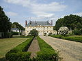
Ennery Castle

Croix d'Autel


,_croix_d%27Autel.jpg)
Personalities
- Hélène Brion (1882–1962)
Community partnerships
There are partnerships with the German city of Oberriexingen in Baden-Württemberg and with the French community of the same name in Ennery in the Moselle department .
literature
- Le Patrimoine des Communes du Val-d'Oise. Flohic Éditions, Volume 2, Paris 1999, ISBN 2-84234-056-6 , pp. 882-886.