Tennengebirge
| Tennengebirge | |
|---|---|
| Highest peak | Raucheck ( 2430 m above sea level ) |
| location | Northern Limestone Alps , Salzburg , Austria |
| Classification according to | AVE 13, Trimmel 1510/1511 |
| Coordinates | 47 ° 30 ' N , 13 ° 14' E |
|
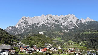
Southwest view of the Tennengebirge. In the foreground the market town of Werfen and the Hohenwerfen Fortress |
|
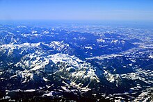
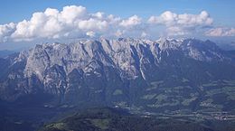
The Tennengebirge is a mountain group of the Northern Limestone Alps in the Eastern Alps . It is a heavily karst and cave-rich plateau mountain range of around 60 km² . It is located in Austria in the state of Salzburg near Bischofshofen .
3 km² of the Tennengebirge plateau are located above 2000 meters above sea level. The Tennengebirge, located entirely in the Salzburg region, is a nature reserve.
geography
Boundary and neighboring mountain groups
The boundary of the Tennengebirge is formed:
- to the Osterhorn group ( Salzkammergut mountains or Salzburg limestone foothills ) in the north and northeast through the Lammer to the Russbach , which comes from the Gschütt pass
- in the east to the Dachstein Mountains through the Lammertal to Lungötz
- In the south it borders on the Fritztaler Mountains (the part of the Salzburg Slate Alps to the right of the Salzach; Hochgründeck , Roßbrand ) along the Karbach line to St. Martin - Fritzbach - Salzach to Bischofshofen
- in the west it is separated from the Hochkönigstock and Hagengebirge , parts of the Berchtesgaden Alps , by the Salzach from Bischofshofen via Tenneck to Ofenau (municipality of Golling) . Here at the northern end of the Lueg pass is the narrowest point on the limestone gorge of the Salzach.
Classification and structure
The Tennengebirge is listed in the Alpine Club division of the Eastern Alps (AVE) as a separate group (No. 13) of the Northern Eastern Alps , as well as in the mountain group classification according to Trimmel (1510), where the whole group belongs to the Western Salzkammergut Alps (1500). In terms of geography, it is part of the Salzburg High Limestone Alps .
The Tennengebirge is divided into the actual compact Tennengebirge massif (Trimmel 1511 Tennengebirge ), from which one can still distinguish the southern slope as a sub-area without a distinctive orographic boundary, and the Strubberg (Trimmel 1512), which lies as an upstream Inselberg zone in the Lammertal.
Valley locations
Parishes are (counterclockwise):
- Throw
- Parish throw
- Werfenweng
- Sankt Martin am Tennengebirge
- Annaberg-Lungötz
- Abtenau
- Scheffau am Tennengebirge
- Golling
summit

The highest peaks are Raucheck ( 2430 m above sea level ) in the western part and Bleikogel ( 2412 m above sea level ) in the eastern part of the mountains. The highest peaks are on the southern edge of the plateau, which slopes down to the north. List of the most important peaks:
|
|
geology
The Tennengebirge is a strongly karstified mountain range , which mainly consists of Dachstein limestone , which rests on a base made of Ramsaudolomite .
The southern foothills, along the line Lungötz - Werfenweng - Werfen , belong to a shed zone . This zone of Werfen strata from the Lower Triassic and Middle Triadic Dolomites ( Anisium , Ladinium ) is called the Werfen – St. Martin shed zone .
caves
There are numerous caves in the Tennengebirge .
- The most famous cave is the approximately 42 km long Eisriesenwelt near Werfen , which is considered the largest ice cave in the world and whose ice part is accessible as a show cave .
- Well-known caves close to the valley are the Brunnecker cave at Pass Lueg , the Winnerfall cave near Oberscheffau and the Trickl cave near Abtenau . These caves are active water caves, which can be flooded in large parts when the snow melts or other floods.
- Another important cave system are the connected caves Platteneckeishöhle - Bergerhöhle - Bierloch in the northwest of the mountain range. This system drains in the direction of the Brunnecker cave , with which it reaches a total height difference of more than 1000 m.
- Other important caves are the snow hole on the Kuchelbergalm
- and the Eiskogel cave , which crosses the mountain of the same name on the southern edge of the Tennengebirge
The Tennengebirge is the preferred research area of the State Association for Speleology in Salzburg, which collects and publishes the research results. New caves are still being discovered, but well-known ones always reveal something of their secrets.
Knowledge of the caves and the paths that the water takes in them is particularly important with regard to the future water supply for the population and the protection of water resources.
Nature and landscape protection
|
Tennengebirge
|
|
| location | Salzburg , Austria |
| Area / extent | 85.417 km² / 16.3 km |
| Identifier | NSG00005 |
| Geographical location | 47 ° 32 ' N , 13 ° 17' E |
| Sea level | from 650 m to 2430 m |
| Setup date | 1982 |
The entire rocky high plateau of the Tennengebirge is designated as a nature reserve Tennengebirge ( NSG 5 ), with 8541.7 ha. It extends from north Stegenwald to the Traunstein and the Königswand west-east over a good 16 km, and the mountains via Scheffau to the southern flank north-south over 9 km. It was established in 1982. It includes areas of the localities and cadastral communities Obergäu (Golling community), Scheffau , Unterberg and Au (Abtenau community), Lammerthal (St. Martin community), Weng (Werfenweng community) , Lampersbach and Schlaming (Pfarrwerfen community) and Wimm (Werfen community) .
|
Tennengebirge
|
|
| location | Salzburg , Austria |
| Area / extent | 47.813 km² / 16.2 km |
| Identifier | LSG00058 |
| Geographical location | 47 ° 30 ' N , 13 ° 17' E |
| Sea level | from 515 m to 2000 m |
| Setup date | 1965 |
The southern foothills are designated in the form of a buffer zone as the Tennengebirge landscape protection area ( LSG 58 ), with 4781.3 ha. This extends in an arc from the Passruckgraben near Lungötz via Lammerthal, Sonnberg (Hüttau municipality) , Weng, Lampersbach, Lehen , Maier and along the Tauern Autobahn from Wimm to Stegenwald. These also include Hofschoberberg , Brandlköpfe , western flank of the Frommer Kogel , Ladenberg – Bischlinghöhe and Hirschkogel , as well as the Zetzenbergkogel near Werfen. It was established in 1965.
The protection purpose of the nature reserve is to preserve the originality of the "mighty limestone mountain range with a diverse karst treasure", typical dry limestone sites, the plant communities and the wealth of animals, the preservation of the landscape preservation of the special scenic beauty and "the special importance for recreational use (hiking tourism) of the partially original Landscape as well as near-natural cultural landscape ”.
Alpinism
As a plateau mountain range, the Tennengebirge offers mountain hikers worthwhile opportunities for crossing. Attention should be paid to the scarcity of water in the karst and the risk of getting lost in fog. Alpine experience and a good physical condition are a basic requirement, even if there are sufficient refuges . The precipices on the edge of the plateau offer the climber a rich field of activity. The walls on the southern edge of the mountains around the Werfener Hütte and above the Dr.-Heinrich-Hackel-Hütte are particularly popular because of their easy accessibility. Various ski tours are worthwhile in winter, most of which will involve extensive plateau crossings, but extreme ski tours are also possible in the Tennengebirge.
Huts
Huts are:
|
|
Long-distance / long-distance hiking trails
The European long-distance hiking trail E4 / Nordalpenweg 01 / Via Alpina ( Violetter Weg, stage A34 / 35) runs through the southern Tennengebirge, from Lungötz to Werfen via the Dr. Heinrich Hackel Hut.
In addition, the Salzburg Arnoweg leads along the west of the group (section 6 Kalkberge Ost , section 52 Annaberg – Laufener Hütte and 53 to Abtenau).
Web links
- www.tennengebirge.info
- Alpine pastures of the Bavarian-Austrian Kalkhochalpen | Alpine pastures in the Tennengebirge , University of Salzburg
Individual evidence
- ↑ Alpine association division of the Eastern Alps
- ↑ Lukas Plan: Verbal description of the delimitation of the subgroups of the Austrian cave directory . Status: Jan 08 2008. Ed .: Association of Austrian Speleologists. ( hoehle.org [PDF; 321 kB ; accessed on May 15, 2018]).
- ^ Herbert Weingartner: The geological situation. ( Memento from August 20, 2011 in the Internet Archive ) In: Preservation, opportunities and further development of tourism to ensure sustainable development in the "Southern Tennengebirge" region. Institute for Geography and Applied Geoinformatics, Salzburg (status: October 9, 2000)
- ↑ a b Tennengebirge in the nature reserve book of the state of Salzburg
- ↑ LGBl. No. 18/1982, LGBl. No. 35/2000
- ↑ a b Tennengebirge in the nature reserve book of the state of Salzburg
- ↑ LGBl. No. 55/1965
- ^ Hütten im Tennengebirge , OeAV
- ↑ Tristlhütte ( Memento of the original from May 14, 2014 in the Internet Archive ) Info: The archive link was inserted automatically and has not yet been checked. Please check the original and archive link according to the instructions and then remove this notice. , edelweissclub.at
- ↑ Section 6 - Limestone Mountains East. In: The Arnoweg. SalzburgerLand, accessed on May 14, 2010 .


