
Mustang (district)
| मुस्ताङ जिल्ला Mustang District
|
|
|---|---|
 Location of the Mustang district (red) in Nepal |
|
| Basic data | |
| Country | Nepal |
| province | Gandaki |
| Seat | Jomsom |
| surface | 3573 km² |
| Residents | 13,452 (2011 census) |
| density | 3.8 inhabitants per km² |
| ISO 3166-2 | NP-P4 |
 |
|
Coordinates: 28 ° 47 ' N , 83 ° 44' E
The Mustang district ( Nepali मुस्ताङ जिल्ला ) is one of 77 districts in Nepal . Mustang District is located in the north of the Dhaulagiri Administrative Zone . It extends over the upper river valley of the Kali Gandaki . The northern two thirds of the district (today: Upper Mustang ) correspond to the former Kingdom of Lo ( Kingdom of Mustang ), which was annexed by the Kingdom of Gorkha in the 18th century and thus became part of Nepal. The culture was and is still strongly influenced by Tibet .
Residents
At the 2001 census it had 14,981 inhabitants; in 2011 there were 13,452. This makes it the district with the lowest population in Nepal after Manang .
Administrative division
The following Village Development Committees (VDCs) are located in the Mustang District :
- Charang (Tsarang)
- Chhonhup
- Chhoser
- Chhusang
- Dhami
- Jhong
- Jomsom
- Kagbeni
- Kowang
- Kunjo
- Lete
- Lo Manthang
- Marpha
- Muktinath
- Surkhang
- Tukuche
climate
Mustang has a continental mountain climate; the temperatures increase steadily from north to south. In Lo Manthang, for example, temperatures can drop to below −20 ° C at night, while in Jomsom they do not even reach −10 ° C. In addition, Mustang is one of the driest regions in Nepal as it lies in the rain shadow of the main Himalayan ridge.
| Jomsom | ||||||||||||||||||||||||||||||||||||||||||||||||
|---|---|---|---|---|---|---|---|---|---|---|---|---|---|---|---|---|---|---|---|---|---|---|---|---|---|---|---|---|---|---|---|---|---|---|---|---|---|---|---|---|---|---|---|---|---|---|---|---|
| Climate diagram | ||||||||||||||||||||||||||||||||||||||||||||||||
| ||||||||||||||||||||||||||||||||||||||||||||||||
|
Average monthly temperatures and rainfall for Jomsom
Source: [2]
|
|||||||||||||||||||||||||||||||||||||||||||||||||||||||||||||||||||||||||||
| Lo Manthang | ||||||||||||||||||||||||||||||||||||||||||||||||
|---|---|---|---|---|---|---|---|---|---|---|---|---|---|---|---|---|---|---|---|---|---|---|---|---|---|---|---|---|---|---|---|---|---|---|---|---|---|---|---|---|---|---|---|---|---|---|---|---|
| Climate diagram | ||||||||||||||||||||||||||||||||||||||||||||||||
| ||||||||||||||||||||||||||||||||||||||||||||||||
|
Monthly average temperatures and rainfall for Lo Manthang
Source: [4]
|
|||||||||||||||||||||||||||||||||||||||||||||||||||||||||||||||||||||||||||
photos
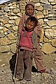
Children in Mustang

Kali Gandaki Valley


.jpg)
Web links
Individual evidence
- ↑ Central Bureau of Statistics, Census 2011: National Report (pp. 51–52, Population Total and Area in Sq. Km ). ( Memento of the original from April 18, 2013 in the Internet Archive ) Info: The archive link was inserted automatically and has not yet been checked. Please check the original and archive link according to the instructions and then remove this notice. (PDF; 7.8 MB)
Achham | Arghakhanchi | Baglung | Baitadi | Bajhang | Bajura | Bank | Bara | Bardiya | Bhaktapur | Bhojpur | Chitwan | Dadeldhura | Dailekh | Dang Deukhuri | Darchula | Dhading | Dhankuta | Dhanusha | Dolakha | Dolpa | Doti | Gorkha | Gulmi | Humla | Ilam | Jajarkot | Jhapa | Jumla | Kabhrepalanchok | Kailali | Calicot | Kanchanpur | Kapilbastu | Kaski | Kathmandu | Khotang | Lalitpur | Lamjung | Mahottari | Makwanpur | Manang | Morang | Mugu | Mustang | Myagdi | Nawalparasi (Bardaghat Susta East) | Nawalparasi (Bardaghat Susta West) | Nuwakot | Okhaldhunga | Palpa | Panchthar | Parbat | Parsa | Pyuthan | Ramechhap | Rasuwa | Rautahat | Rolpa | Rukum East | Rukum West | Rupandehi | Salyan | Sankhuwasabha | Saptari | Sarlahi | Sindhuli | Sindhupalchok | Siraha | Solukhumbu | Sunsari | Surkhet | Syangja | Tanahu | Taplejung | Terhathum | Udayapur