
Kreischa
| coat of arms | Germany map | |
|---|---|---|

|
Coordinates: 50 ° 57 ' N , 13 ° 46' E |
|
| Basic data | ||
| State : | Saxony | |
| County : | Saxon Switzerland-Eastern Ore Mountains | |
| Height : | 257 m above sea level NHN | |
| Area : | 28.92 km 2 | |
| Residents: | 4532 (Dec. 31, 2019) | |
| Population density : | 157 inhabitants per km 2 | |
| Postal code : | 01731 | |
| Area code : | 035206 | |
| License plate : | PIR, DW, FTL, SEB | |
| Community key : | 14 6 28 220 | |
| LOCODE : | DE KSC | |
| Community structure: | 14 districts | |
| Address of the municipal administration: |
Dresdner Strasse 10 01731 Kreischa |
|
| Website : | ||
| Mayor : | Frank Schöning | |
| Location of the community Kreischa in the district of Saxon Switzerland-Eastern Ore Mountains | ||
  |
||


Kreischa is a municipality in the district of Sächsische Schweiz-Osterzgebirge in Saxony and is located south of Dresden in the valley of the Lockwitzbach .
geography
Community structure
The districts belong to the municipality :
|
Desolation
The possibly identical deserted areas of Olberndorf and Pfütze lie on Kreischaer Flur . Olberndorf had a share in the corridors of Röhrsdorf , Pfütze had a share in the corridors of Wittgensdorf, Großborthen and Gombsen in addition to Röhrsdorf. The manors of Röhrsdorf and Borthen exercised the manorial rule .
geology

The landscape of Kreischa belongs to the northeastern slope of the Ore Mountains. The community is located in the Döhlen basin whose Rotliegend sediments separate the gneisses of the eastern Ore Mountains from the Elbe Chalk. The Rotliegend layers contain coal seams, which, however, cannot be mined profitably by today's standards. In the past, however, hard coal mining was also carried out in the area around Kreischa, albeit to a much lesser extent than in neighboring Freital. The former Cotta shaft between Kleinkarsdorf and Quohren and the Dippold shaft at the Hornschänke are evidence of this . In some of the old walls of the church property and on the Lungkwitzer Gut, reddish, layered sandstones of the Rotliegend were built, which were broken in the area.
geomorphology
The Quohrener Water, which forms the main axis of the town, flows into the Lockwitzbach near Kreischa . The valleys that cleared these two bodies of water, together with the flat undulating area in the vicinity of Kreischa, are known as the “ Kreischa Basin ”. The southeastern border of the basin is formed by a ridge near the Karsdorf fault line with the Wilischberg ( basalt ). The Babisnauer Poplar natural monument roughly marks the northern edge of the basin. The Kreischa basin is drained by the Lockwitzbach and its tributaries through the Lockwitzgrund to the Elbe .
climate
With its humid climate, Kreischa is located in the cool, temperate climate zone . The community is located in the transition area between the humid Atlantic and dry continental climates . According to the Köppen-Geiger climate classification, Kreischa is part of the warm, temperate rainy climate (Cfb climate). The mean air temperature of the warmest month remains below 22 ° C and that of the coldest month above -3 ° C.
The average annual rainfall is 610 mm, with an overweight in summer. July is the wettest month with 80 mm. February has the least precipitation with an average of 33 mm. The mean temperature over the entire year is 8.3 ° C. From a climatological point of view, July is the warmest month of the year with an average of 17.7 ° C. The lowest temperatures are recorded in January with an average of −1.4 ° C.
|
Average monthly temperatures and rainfall for Kreischa
Source:
|
|||||||||||||||||||||||||||||||||||||||||||||||||||||||||||||||||||||||||||||||||||||||||||||||||||||||||||||||||||||||||||||||||||||||||||||||||||||||||||||||||||||
Protected areas
- Landscape protection area "Lockwitztal and Gebergrund"
- Landscape protection area "Dippoldiswalder Heide and Wilisch"
- FFH area “Lockwitzgrund and Wilisch”: The 309 hectare European protected area comprises the valley of the Lockwitzbach and its tributaries Wilischbach and Hirschbach in two separate areas. The habitats are mostly wooded slopes with diverse hardwood stands, open rock formations and, in the north, orchards.
traffic
The Saxon state roads 36 and 183 run through Kreischa . The next motorway junction is “Heidenau / Sa.” On the federal motorway 17 . The next train station is Dresden-Niedersedlitz in the Dresden S-Bahn network . Until 1977 the Lockwitztalbahn connected Kreischa with the train station. Regional traffic between Saxon Switzerland and the Eastern Ore Mountains and Dresden public transport companies operate the joint bus route 86/386 / F. This connects Kreischa every 20 minutes with the S-Bahn station Dresden-Dobritz and Prohlis. Line 386 runs from Kreischa to Glashütte , line F continues to Freital while line 86 ends in Kreischa.
history

In 1282 the place was first mentioned in the name of a Heinricus de Kryschowe . The place name can be interpreted from old Slavic roots as "village of the crooked, lame".
The village of Kreischa originally consisted of the districts
- Niederkreischa, a row village with manor blocks and block parcels
- Mittelkreischa, a single row forest hoof village
- Oberkreischa, also a single row forest hoof village
In 1378 the place belonged to the castrum Dresden, around 1440 probably on the border of the care Dohna and the care Dresden. In 1539 the first (Lutheran) parish was mentioned in Kreischa. In 1547 the manor was divided between two manors, Oberkreischa and Unterkreischa. From 1547 to 1856 Oberkreischa (1620: "Gros Kreuscha") belonged to the Dresden office , the former Dohna Unterreischa ("Klein Kreuscha") and the property belonging to the Zehista manor belonged to the Pirna office . In 1834 the place received market rights. In 1856 Kreischa belonged to the Dippoldiswalde judicial district and from 1875 to 1952 to the Dippoldiswalde district administration . During this time the place developed into a summer resort and a climatic health resort at the gates of Dresden. An overland tram, the “ Lockwitztalbahn ”, was built through the Lockwitzgrund and was in operation from 1904 to 1977.
In 1952, Kreischa and today's districts became part of the Freital district (later the district ). In 1973 the municipalities of Gombsen, Kleincarsdorf, Lungkwitz, Quohren and Theisewitz were incorporated.
In 1994 the communities Bärenklause-Kautzsch and Sobrigau were incorporated and Kreischa became part of the newly formed Weißeritzkreis . In 2001 the evangelical parish of Kreischa was integrated into the parish of Possendorf-Kreischa. In 2008 the municipality of Kreischa became part of the newly formed district of Saxon Switzerland-Eastern Ore Mountains.
coat of arms
|
|
Blazon : “Split by green and gold; in the right field on a corrugated shield base divided three times by silver and blue, a silver fan emerging from the split; in the left field a black right pole flank, ending in the form of a left upper stand, on the left accompanied by a black poplar leaf. " |
|
Justification for the coat of arms: The water (wave shield foot) represents the fish-rich and landscape- defining Lockwitz , the source (fan) the "sleeping well", the water of which is said to have healing properties. The Babisnau poplar , a German black poplar (there are only two genetically pure black poplars in the Dresden area), which was planted as a border tree in 1808 , is visible far beyond the town limits of Kreischa . The felling of the poplar was prevented in 1884 by the purchase of the mountain association. In 1937 it was placed under nature protection.
The representation of the tree (as a drawbar) goes back to a kabbalistic, old Germanic and astrological basic meaning. This is based on the coat of arms of the von Carlowitz (manorial estate owners and noble family), whose colors are black on a silver background. The colors black and gold stand for the proximity to Dresden and green and silver reflect the colors of Saxony. |
Development of the population
|
|
|
|
politics
_2006-06-27.jpg)
Municipal council
Since the municipal council elections in 2019 , the 16 seats of the municipal council have been distributed among the individual groups as follows:
- Free Citizens' Representation Kreischa e. V. (FBK): 9 seats
- CDU : 1 seats
- LEFT : 1 seats
- AfD: 5 seats
mayor
Mayor Frank Schöning was re-elected in June 2015 with 96.6% of the vote.
Town twinning
Kreischa cultivates partnership relationships
- Loffenau (Rastatt district) in Baden-Württemberg, since 1990
- Háj u Duchcova (Northern Bohemia) in the Czech Republic, since 2005
_2006-06-27.jpg)

economy
The largest local employer is the Bavaria clinic . The Institute for Doping Analysis and Sports Biochemistry , a WADA- recognized doping control laboratory that emerged from the central institute with a rehabilitation center and doping control laboratory (see also: Sports Medicine Service of the GDR ), is also well-known nationwide .
Culture and sights
_2006.JPG)
Buildings
- Manor house of the former Oberkreischa manor : built around 1840/50 as a result of reconstruction in the classicist style, today the seat of the municipal administration and library
- Evangelical parish church Kreischa : According to art historical research, the Romanesque church was built after 1150 and rebuilt in 1516. The hall-like floor plan and the widespread use of such churches during the colonization phase in the Margraviate of Meissen suggests that the parish church is very old. Several architectural elements point to a Romanesque era. The Romanesque character was changed through a series of renovations. The octagonal tower top with a tail gives the sacred building a baroque look.
- Gänselieselbrunnen Kreischa: built in 1911 in honor of Ferdinand Haußmann (owner of the Kreischa manor, councilor and local judge), bronze sculpture by the sculptor Max Dittert
- Old Kreischa sanatorium
- Lungkwitz Castle and Abbey : a complex that emerged from an old moated castle, built between 1619 and 1621. After a long period of vacancy, the renovation was carried out and was completed in November 2014. The property is now a residential complex.
- The old inn "Zum Erbgericht" on Haußmannplatz in the center of Kreischa has been renovated since 2017.
Kreischaer Park
- The Kreischa park in the vicinity of the historic manor house, today's town hall, was laid out by Countess Fredericke von Reinhold between 1786 and 1825.
- Robert Schumann bust in the spa gardens, erected in 1997 by the art and culture association “Robert Schumann” Kreischa e. V.
- Peter Schreier bust in the spa gardens of Kreischa made of bronze by the sculptor Hans Kazzer
Natural monuments
- Babisnau poplar (tree)
- Wilisch (mountain, 476 meters)
- Quohrener Kipse (mountain, 452 meters)
gallery
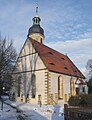
Evangelical parish church

The Gänselieselbrunnen

Babisnau poplar

Lungkwitz Castle
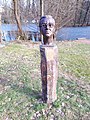
Peter Schreier bust in the spa gardens

Robert Schumann bust in the spa gardens


Sports
Kreischa became world-famous through his Institute for Doping Analysis and Sports Chemistry Kreischa, founded in 1992 . Kreischa was already a national center for sports chemistry during the GDR . In 1990 legal ownership was transferred to the Kreischa municipality. When the German Unification Treaty came into force, the Sports Medical Service was dissolved. On October 4, 1990, the central institute was transferred to the Bavarian Clinic by resolution of the municipal council .
The Institute operates according reorientation again as Dopingkontrollabor, an affiliated institute of the TU Dresden and accredited doping control laboratory of WADA . The institute director is Detlef Thieme.
Personalities
The Kreischa community awarded the managing director of the Kreischa Clinic, Rudolf Presl, honorary citizenship on July 12, 2012 because of his services to the community .
- Rudolf Hugo Hofmann (born January 3, 1825 in Kreischa; † February 19, 1917), theologian and secret councilor
- Claus Weselsky (born February 18, 1959 in Dresden), union leader, grew up in Kreischa and lived there until 1990
literature
- Richard Steche : Kreischa. In: Descriptive representation of the older architectural and art monuments of the Kingdom of Saxony. 2. Issue: Amtshauptmannschaft Dippoldiswalde . CC Meinhold, Dresden 1883, p. 45.
Web links
Individual evidence
- ↑ Population of the Free State of Saxony by municipalities on December 31, 2019 ( help on this ).
- ↑ Olberndorf in the Digital Historical Directory of Saxony
- ↑ Puddle in the Digital Historical Directory of Saxony
- ^ R. Beck, Kurt Pietzsch: Explanations of the special geological map of the Kingdom of Saxony. Leaf Kreischa . Ed .: Saxony, Ministry of Finance; Saxony, geological survey. 2nd Edition. No. 82 . GA Kaufmanns Buchhandlung, Dresden 1917, p. 1 .
- ↑ Climate & weather in Kreischa. AM Online Projects, accessed October 2, 2017 .
- ↑ Climate-Data.org
- ↑ Profiles of the Natura 2000 areas: 5048-301 Lockwitzgrund and Wilisch (FFH area). Federal Agency for Nature Conservation (BfN), 2015, accessed on August 6, 2017 .
- ^ Kreischa coat of arms statute. (PDF) § 2 Paragraph 2. kreischa.de, December 13, 2004, p. 4 , accessed on November 21, 2017 .
- ↑ Coat of arms of the Kreischa community. kreischa.de, accessed on November 21, 2017 .
- ↑ Kreischa in the Digital Historical Directory of Saxony
- ↑ [1]
- ↑ Hans Joachim Kessler: Kreischa: Rehabilitation between past and present . Ed .: Municipality of Kreischa. 2004, p. 47 .
- ↑ Hermine Hofmann: Of straw hats, cigars and strangers: Kreischa in history and stories: A home book . Ed .: Reiner Groß. Druckerei und Verlagshaus Blume, Kreischa 2015, p. 276 f .
- ^ [2] IDAS Dresden
- ↑ 1. Honorary citizenship of the Kreischa community awarded to Mr. Rudolf Presl. (PDF; 4.8 MB) In: Kreischaer Bote. August 2, 2012, p. 4 , accessed March 1, 2017 .
- ^ Matthias Weigel: Rudolf Presl is Kreischa's first honorary citizen. In: Sächsische Zeitung , August 3, 2012.
Altenberg | Bad Gottleuba-Berggießhübel | Bad Schandau | Bahretal | Bannewitz | Dippoldiswalde | Dohma | Dohna | Village grove | Dürrröhrsdorf-Dittersbach | Freital | Glassworks | Gohrisch | Hartmannsdorf-Reichenau | Heidenau | Hermsdorf / Erzgeb. | Hohnstein | Klingenberg | Königstein (Saxon Switzerland) | Kreischa | Liebstadt | Wages | Müglitztal | Neustadt in Saxony | Pirna | Rabenau | Rathen | Rathmannsdorf | Reinhardtsdorf-Schöna | Rosenthal-Bielatal | Sebnitz | City of Wehlen | Stumble | Struppen | Tharandt | Wilsdruff
Babisnau | Bear Clause | Brösgen | Gombsen | Kautzsch | Kleba | Kleincarsdorf | Kreischa | Lungkwitz | Quohren | Saida | Sobrigau | Theisewitz | Wittgensdorf | Zscheckwitz