
Donaustauf
| coat of arms | Germany map | |
|---|---|---|

|
Coordinates: 49 ° 2 ' N , 12 ° 12' E |
|
| Basic data | ||
| State : | Bavaria | |
| Administrative region : | Upper Palatinate | |
| County : | regensburg | |
| Management Community : | Donaustauf | |
| Height : | 358 m above sea level NHN | |
| Area : | 9.72 km 2 | |
| Residents: | 4190 (Dec. 31, 2019) | |
| Population density : | 431 inhabitants per km 2 | |
| Postal code : | 93093 | |
| Area code : | 09403 | |
| License plate : | R. | |
| Community key : | 09 3 75 130 | |
| Market structure: | 7 districts | |
Market administration address : |
Wörther Strasse 5 93093 Donaustauf |
|
| Website : | ||
| Mayor : | Jürgen Sommer ( SPD ) | |
| Location of the Donaustauf market in the Regensburg district | ||
  |
||

Donaustauf is a market in the Upper Palatinate district of Regensburg in Bavaria and the seat of the Donaustauf administrative community .

The place had market rights as early as 1494 and with the Donaustauf castle ruins occupies a prominent position in the Danube landscape. Landmarks are the Walhalla , the castle ruins and the Chinese tower.

geography
location
The market is about ten kilometers east of Regensburg on the edge of the foothills of the Bavarian Forest . The place is dominated by a ruined castle. To the east of Donaustauf lies the Walhalla on a hill ( Bräuberg ) .
Parish parts
There are seven districts:
- Dachsberg
- Donaustauf
- Hammer mill
- Bracket
- Neumühle
- Parking garage
- Sulzbach adDonau (formerly an independent municipality, was incorporated on May 1, 1978 as part of the regional reform)
The former part of the community of Reiflding has been incorporated into the district of Donaustauf.
history
Finds from the area of the castle ruins from 1961 gave rise to the assumption that the castle hill was already settled by Celts , which was confirmed by excavations in 1981/82, with the foundation walls of a fortification from approx. 500 BC. Were found.
The medieval castle ( Castellum Stufo ) was probably built at the time of the Hungarian invasions between 914 and 930 by order of Bishop Tuto on a mountain cone (Old High German stouf ) in the forest district around Sulzbach , after this forestum iuxta sulcipah was donated by King Conrad I to the then cathedral monastery St. Emmeram in Regensburg went. After separating from the monastery and bishopric by the Abbot-Bishop Wolfgang Donaustauf in 1031 went to the diocese.

Until the 13th century Donaustauf could be held in the possession of the Regensburg bishops, although it often got into power struggles between the diocese, king and dukes. In 1285 Donaustauf is first mentioned as comitia Thumstauf . In the 14th century, Donaustauf often changed hands as a pledge (including Emperor Karl IV , Duke Otto V , Duke Stephan II ). In 1486 Donaustauf went together with Regensburg to Duke Albrecht IV , who in 1494 granted Donaustauf market rights .
In the course of the fighting for Regensburg during the Thirty Years War , the castle was besieged by Swedish troops in January 1634 after the Bavarian occupation of the castle had intercepted a 60 truckload of salt for Regensburg, which was occupied by the Swedes in November 1633. On the orders of the Swedish field marshal Bernhard von Sachsen-Weimar , the castle was to be conquered in January 1634 by the troops of the city commander of the occupied city of Regensburg, Lars Kagg . Lars Kagg was wounded in multiple attempts that were rejected with great losses and command was handed over to the Swedish Colonel Claus Hastver . He ordered guns and scaling ladders from Regensburg and had a breach shot. On January 21, the castle garrison had to surrender due to a lack of powder and were given permission to leave. The castle was undermined, blown up on February 16, 1634 and largely destroyed in the process. The Donaustauf Castle has been in ruins since then.
In 1710 Donaustauf came to the Regensburg Monastery and in 1803 it was incorporated into the newly formed Principality of Regensburg by Karl Theodor von Dalberg . With the Paris Treaty , it came to Bavaria in 1810 . In 1812 Bavaria ceded the rule of Donaustauf to the princes of Thurn and Taxis , who had held the hereditary title of Duke of Wörth and Donaustauf since 1899 . The prince's palace, built in 1843, fell victim to a major fire in 1880, which also destroyed around 60% of all residential buildings in the market. King Ludwig I had the so-called Walhalla Hall of Fame built between 1830 and 1842.
In 1907/08 the "lung sanatorium" was built, today the Donaustauf Clinic. Today Donaustauf is the seat of the administrative community Donaustauf, to which the communities Altenthann and Bach an der Donau also belong.
Population development
Between 1988 and 2018 the market grew from 3,338 to 4,124 by 786 inhabitants or 23.6%.
Religions
As in large areas of the Upper Palatinate, the majority of the population in Donaustauf is Roman Catholic. The Catholics belong to the parish Donaustauf, which forms a parish community with the parish Bach ad Donau. The parish belongs to the Donaustauf deanery, which is assigned to the diocese of Regensburg.
The Protestant Christians belong to the Evangelical Church Community of St. Luke in Regensburg.
politics

Market council
The market council consists of 16 voluntary market councils and the first mayor.
The local elections on March 15, 2020 brought the following result:
| Political party | Seats |
|---|---|
| CSU | 7th |
| SPD | 4th |
| Citizen List | 3 |
| Green | 2 |
Of the 3,326 residents in Markt Donaustauf with voting rights, 2,385 exercised their right to vote, bringing the turnout to 71.71 percent.
mayor
Jürgen Sommer ( SPD ) was elected mayor for the first time in a runoff election in 2008 with 61.93% of the vote. In 2014 he was re-elected with 60.26% of the vote. In 2020 he won the runoff election with 55.29% of the vote.
coat of arms
|
|
Blazon : “Split by blue and silver; topped with a golden three-mountain from which a vine with four grapes and two leaves in mixed colors grows. "
Duke Albrecht IV of Bavaria-Munich awarded the coat of arms in 1494. |
| Reasons for the coat of arms: The colors blue and silver are derived from the coat of arms of the Wittelsbach family . The wine stands for the viticulture around Donaustauf. |
Attractions
The market town is rich in sights that can be seen on a circular walk through the town.


-
Donaustauf castle ruins :
Between 914 AD and 930 AD, Bishop Tuto of Regensburg had a castle built here to ward off the Hungarian invasions. In the years 1132–1161 it was conquered four times and partially destroyed. The Donaustauf market developed in the Middle Ages as a bourgeois settlement under the protection of the mighty fortifications of the castle. During the Thirty Years War , in January 1634, the Donaustauf fortress was conquered, blown up and burned by the Swedes. After that, it was poorly repaired and fell into disrepair at the end of the 17th century. It has belonged to the Donaustauf market since 1986.

Valhalla
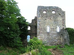
Part of the castle ruins

Leo von Klenze : Salvatorkirche and Walhalla


-
Pilgrimage Church of St. Salvator :
Built in the 15th century in the Gothic style. In the 18th century it was converted to Baroque style and in 1843, on behalf of King Ludwig I, Leo von Klenze adapted it to the style of the Walhalla. The origin of the pilgrimage is based on a host robbery in 1388 during a siege of the castle.
-
Parish Church of St. Michael :
Choir tower church with octagonal tower with tent roof, 1724, medieval tower, before 1388; with equipment; Sections of the cemetery wall, probably 18th century.
-
Fortified church St. Martin in the district of Sulzbach :
Hall building with hipped gable roof and shingled roof turret with onion dome, early Gothic, baroque changed; Cemetery wall made of granite rubble, late Gothic.
- Chinese Tower: In
1842, Prince Maximilian Karl von Thurn und Taxis built the now well-known Chinese Tower in his palace garden in Donaustauf. The new building replaced a similar tower that had already been built under Maximilian Karl's father, Karl Alexander von Thurn und Taxis . The tower survived the major fire of 1880 unscathed, but in 1902 it was moved to the garden of the new summer residence of Thurn und Taxis, CastleChecking . At the instigation of the Förderverein Chinesischer Turm e. V. returned the tower to its original location in 1999 and was then restored.
-
Princely Thiergarten :
Established in 1813 as a hunting forest for the Princes of Thurn and Taxis. The park-like and now publicly accessible landscape with forest houses and hunting huts covers an area of 2,800 hectares, in which lynxes , wild boars , red deer , beavers , otters , black storks , newts , yellow-bellied toads and toads live. There is also a golf course on the site.
Culture
Sports and clubs
Donaustauf has a wide range of clubs with over 40 clubs. The market has several sports facilities from football fields to multi-purpose halls. The largest and most famous club in the market is SV Donaustauf .
The Donaustauf volunteer fire brigade and the Sulzbach volunteer fire brigade provide fire protection and general help in the municipality and beyond.
leisure
In the municipality there are many opportunities for hikes, walks and nature observation on the backwaters of the Danube. There are also numerous hiking and walking trails in the Donaustauf forest, the castle ruins, the Fürstengarten and the Bräuberg on the Walhalla.
Events and exhibitions are often held in the community center and the Chinese Tower. Courses at the Regensburger Land adult education center can also be taken.
Popular meeting points are the nationally known flea market (monthly) as well as the Easter market and the Christmas market in Donaustauf.

Economy and Infrastructure

Donaustauf is a residential community in the eastern catchment area of Regensburg with numerous service, trade and craft businesses. The municipality has good transport connections and, with the Neutraubling junction, it has a direct connection to the federal motorway 3 .
There are numerous doctors, a pharmacy, a specialist hospital and physiotherapy facilities on the market, as well as outpatient nursing. The local supply options are good, and other infrastructural facilities are available.
tourism
The market town of Donaustauf is on the important tourist magnet Walhalla through the Heimat- und Tourismusverein Donaustauf e. V and its tourist information office well adjusted. This information is the central point of contact for Donaustauf and Tegernheim as a travel agency.
Viticulture
Baierwein , which was mentioned in a document as early as the 8th century, thrives in Donaustauf ; there are several wine bars. Donaustauf is located in the second smallest wine-growing region in Germany, and the smallest in Bavaria, on the wine route, which is the shortest German wine route at 20 kilometers.
traffic
Former Walhalla Railway
In the years 1888/89 the Walhalla Railway was built between Stadtamhof and Donaustauf station. In 1903 the continuation to Wörth an der Donau was put into operation. In 1960 passenger traffic was discontinued and the last freight train left the station on December 31, 1968.
Ship landing stage

On the Danube, below the Walhalla, there is a shipping pier for the Regensburg Passenger Shipping Company. From there, ships run regularly to the city of Regensburg, 10 kilometers away.
Biking and hiking trails
Donaustauf is located on numerous bike trails, u. a. on the Danube Cycle Route and on the European EuroVelo 6, which runs under the name of the River Route from the Atlantic to the Black Sea. Donaustauf is also located on the “Walhalla, Wein und Wellen” cycle tour, which partly runs on the Danube Cycle Path. The tour leads from Regensburg to Donaustauf, Bach an der Donau , Wörth an der Donau ( Castle Wörth an der Donau ) and back to Regensburg.
In the southern area along the Danube, the Danube cycle path "Tour de Baroque" crosses the municipality.
Car traffic
Donaustauf is located on the state roads 2145 and 2125 and has a connection to the federal motorway 3 with the Neutraubling motorway junction, which is six kilometers away.
media
The Donau-Post , a local edition of the Straubinger Tagblatt and the Mittelbayerische Zeitung, and the Regensburger Wochenblatt , an edition of the Wochenblatt publishing group, appear in the community . In addition to the national programs, the radio stations Radio Charivari , Radio Gong FM and the regional television station TVA can also be received in the municipality .
Public facilities
- Community center
- Multipurpose hall
- Recycling center
- youth club
- kindergarten
- day care center
- Day nursery
- Community library
education
- primary school
Personalities
Honorary citizen
- Klaus Eder, DFB physiotherapist
Daughters and sons of the place
- Paul von Thurn and Taxis (1843–1879), friend of Ludwig II and actor
literature
- Hermann Hage: Donaustauf - modern market town with a great past , Donaustauf 1994.
Web links
- [www.donaustauf.de municipal administration]
- Information about the castle ruins
- Donaustauf: Official statistics of the LfStat
- Aerial photos of the Donaustauf market
Individual evidence
- ↑ "Data 2" sheet, Statistical Report A1200C 202041 Population of the municipalities, districts and administrative districts 1st quarter 2020 (population based on the 2011 census) ( help ).
- ↑ Municipal Council. Markt Donaustauf, accessed on June 9, 2020 .
- ↑ Markt Donaustauf in the local database of the Bayerische Landesbibliothek Online . Bavarian State Library, accessed on November 28, 2017.
- ^ Federal Statistical Office (ed.): Historical municipality directory for the Federal Republic of Germany. Name, border and key number changes in municipalities, counties and administrative districts from May 27, 1970 to December 31, 1982 . W. Kohlhammer GmbH, Stuttgart / Mainz 1983, ISBN 3-17-003263-1 , p. 658 .
- ↑ Peter Engerisser, Pavel Hrncirik: Nördlingen 1634. The battle near Nördlingen, turning point of the Thirty Years' War. Späthling, Weißenstadt 2009, pp. 25–33, ISBN 978-3-926621-78-8 .
- ↑ https://wahlen.landkreis-regensburg.de/kommunal2020/20200315/09375130/html5/Gemeinderatswahl_Bayern_66_Gemeinde_Markt_Donaustauf.html
- ↑ https://wahlen.landkreis-regensburg.de/kommunal2020/20200315/09375130/html5/BuergermeisterStichwahl_Bayern_75_Gemeinde_Markt_Donaustauf.html
- ↑ Entry on the Donaustauf coat of arms in the database of the House of Bavarian History , accessed on August 5, 2020 .
- ^ Chinese Tower Donaustauf Information from the Förderverein Chinesischer Turm e. V., Donaustauf (PDF)
- ↑ Klaus Eder: Honorary Citizen of Donaustauf , accessed on November 21, 2014.

Cities: Hemau | Neutraubling | Wörth on the Danube
Markets: Beratzhausen | Donaustauf | Kallmünz | Laaber | Lappersdorf | Nittendorf | Regenstauf | hemlock
Municipalities: Alteglofsheim | Altenthann | Aufhausen | Bach on the Danube | Barbing | Bernhardswald | Brennberg | Brunn | Deuerling | Duggendorf | Hail city | Holzheim am Forst | Köfering | Mintraching | Mötzing | Obertraubling | Pentling | Pettendorf | Pfakofen | Pfatter | Pielenhofen | Riekofen | Sinzing | Sünching | Tegernheim | Thalmassing | Wenzenbach | Wiesent | Wolfsegg | Time warning
Unregulated areas: Forstmühler Forst | Kreuther Forest