
Ranrupt
| Ranrupt | ||
|---|---|---|

|
|
|
| region | Grand Est | |
| Department | Bas-Rhin | |
| Arrondissement | Molsheim | |
| Canton | Dirty | |
| Community association | Vallée de la Bruche | |
| Coordinates | 48 ° 22 ′ N , 7 ° 12 ′ E | |
| height | 476-1,013 m | |
| surface | 14.68 km 2 | |
| Residents | 329 (January 1, 2017) | |
| Population density | 22 inhabitants / km 2 | |
| Post Code | 67420 | |
| INSEE code | 67384 | |
 Look at Ranrupt |
||

Ranrupt ( German Roggensbach ) is a French commune with 329 inhabitants (as of January 1, 2017) in the upper valley of the Bruche in the Vosges and in the Bas-Rhin department in the Grand Est region (until 2015 Alsace ). The community belonged to the canton of Saales from the French Revolution until 2015 and to the canton of Mutzig since then . The districts of Le Haut-Ranrupt , Fonrupt , Stampoumont and La Salcée also belong to Ranrupt . There is an early mention of Ranrupt from 1262.
history
On 21/22 August 1914 there was a battle in the context of the Battle of Lorraine with heavy losses on both sides. A military cemetery on the outskirts reminds of this.
coat of arms
Description : A red pole in gold in the middle, each accompanied by a red five-pointed star .
Population development
| 1962 | 1968 | 1975 | 1982 | 1990 | 1999 | 2005 | 2013 |
|---|---|---|---|---|---|---|---|
| 321 | 360 | 309 | 277 | 297 | 293 | 298 | 349 |
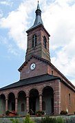
- St. Vincenz Church in Ranrupt


See also
literature
- Le Patrimoine des Communes du Bas-Rhin. Flohic Editions, Volume 2, Charenton-le-Pont 1999, ISBN 2-84234-055-8 , pp. 1050-1052.