
Saint-Martin-l'Ars
| Saint-Martin-l'Ars | ||
|---|---|---|
|
||
| region | Nouvelle-Aquitaine | |
| Department | Vienne | |
| Arrondissement | Montmorillon | |
| Canton | Civray | |
| Community association | Vienne et Gartempe | |
| Coordinates | 46 ° 13 ' N , 0 ° 32' E | |
| height | 132-169 m | |
| surface | 41.76 km 2 | |
| Residents | 386 (January 1, 2017) | |
| Population density | 9 inhabitants / km 2 | |
| Post Code | 86350 | |
| INSEE code | 86234 | |
| Website | http://www.saint-martin-lars.fr/ | |

Saint-Martin-l'Ars is a western French community with 603 inhabitants (as of January 1 2017) in the department of Vienne in the region Nouvelle-Aquitaine . The municipality belongs to the arrondissement of Montmorillon and the canton of Civray (until 2015: canton of Availles-Limouzine ).
location
Saint-Martin-l'Ars is located about 42 kilometers south-southeast of Poitiers at an altitude of about 146 meters above sea level. d. M. am Clain . Saint-Martin-l'Ars is surrounded by the neighboring communities of Usson-du-Poitou in the north, Le Vigeant in the east, Availles-Limouzine in the south-east, Pressac in the south, Mauprévoir in the south and south-west and Payroux in the west.
The former Route nationale 741 runs through the municipality .
Population development
| year | 1962 | 1968 | 1975 | 1982 | 1990 | 1999 | 2006 | 2013 |
| Residents | 850 | 748 | 599 | 515 | 417 | 389 | 407 | 384 |
| Source: Cassini and INSEE | ||||||||
Attractions
- Villaigue dolmen, historic monument since 1980
- Saint Martin Church
- Notre-Dame de la Réau monastery

Saint Martin Church
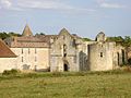
Notre-Dame de la Réau monastery


literature
- Le Patrimoine des Communes de la Vienne. Volume 1, Flohic Editions, Paris 2002, ISBN 2-84234-128-7 , pp. 46-49.