Saulgé
| Saulgé | ||
|---|---|---|
|
|
||
| region | Nouvelle-Aquitaine | |
| Department | Vienne | |
| Arrondissement | Montmorillon | |
| Canton | Montmorillon | |
| Community association | Vienne et Gartempe | |
| Coordinates | 46 ° 23 ' N , 0 ° 53' E | |
| height | 87-202 m | |
| surface | 62.31 km 2 | |
| Residents | 1,013 (January 1, 2017) | |
| Population density | 16 inhabitants / km 2 | |
| Post Code | 86500 | |
| INSEE code | 86254 | |
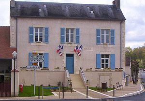
 Saulgé Town Hall (Mairie) |
||
Saulgé is a French village with 1,013 inhabitants (as of January 1 2017) in the department of Vienne in the region Nouvelle-Aquitaine ; it is part of the arrondissement of Montmorillon and the canton of Montmorillon .
geography
Saulgé is about 46 kilometers southeast of Poitiers . Saulgé is surrounded by the neighboring communities of Montmorillon in the north and north-east, Lathus-Saint-Rémy in the east and south-east, Plaisance in the south, Moulismes in the south and south-west, Persac in the west and south-west and Sillars in the west and north-west.
Population development
| year | 1793 | 1876 | 1962 | 1968 | 1975 | 1982 | 1990 | 1999 | 2006 | 2011 | 2013 | 2014 |
| Residents | 1.012 | 1,364 | 948 | 868 | 904 | 950 | 1,020 | 980 | 967 | 978 | 1.004 | 1.012 |
| Source: Cassini and INSEE | ||||||||||||
Attractions
- Saint-Divitien church from the 11th century
- Beaupuy Castle
- Donjon von Lenest, remains of a castle from the 14th century, a historic monument since 1990
Web links
Commons : Saulgé - collection of images, videos and audio files
