Mazerolles (Vienne)
| Mazerolles | ||
|---|---|---|
|
|
||
| region | Nouvelle-Aquitaine | |
| Department | Vienne | |
| Arrondissement | Montmorillon | |
| Canton | Lussac-les-Châteaux | |
| Community association | Vienne et Gartempe | |
| Coordinates | 46 ° 24 ' N , 0 ° 41' E | |
| height | 70-151 m | |
| surface | 21.25 km 2 | |
| Residents | 851 (January 1, 2017) | |
| Population density | 40 inhabitants / km 2 | |
| Post Code | 86320 | |
| INSEE code | 86153 | |
 Mazerolles - Dolmen de Loubressac |
||
Mazerolles is a western French city and a municipality ( commune ) with 851 inhabitants (at January 1, 2017) in the department of Vienne in the region Nouvelle-Aquitaine .
location
Mazerolles is located on the west bank of the Vienne about 38 kilometers (driving distance) southeast of the departmental capital Poitiers at an altitude of about 90 m above sea level. d. M.
Population development
| year | 1968 | 1975 | 1982 | 1990 | 1999 | 2007 | 2012 |
| Residents | 618 | 650 | 704 | 697 | 763 | 779 | 829 |
In the 19th century the population rose from around 300 to approximately 800; the mechanization of agriculture led to job losses in the first half of the 20th century and to a marked decline in population numbers to the lows of the 1950s and 1960s.
economy
For centuries agriculture , which was formerly mainly self-sufficient , has played the largest role in the municipality's economic life. Are grown wheat , barley and corn as well as rapeseed and sunflower oil recovery. A part of the total area of around 2000 hectares is reserved for the cultivation of feed, which is needed by the ranchers in the area. Some vacant houses were converted into holiday flats ( gîtes ).
history
The existence of a Romanesque , in parts also late Gothic church suggests a medieval settlement of the place. On December 31, 1369, the English military leader John Chandos was fatally wounded in a skirmish or assassination attempt on the bridge to Lussac-les-Châteaux ; a stone cenotaph memorial reminds of this.
Attractions
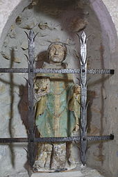
- The parish church of Saint-Romain is a rural quarry stone building from the 12th century with a Renaissance four-part bell gable above the otherwise unadorned west facade. The portal surround protrudes slightly from the wall. The single nave nave is barrel vaulted; the transition to the flat-closing apse is formed by a Gothic choir arch made of precisely hewn stones. A polychrome statue of St. Silvin von Toulouse is considered a small masterpiece of rural sculpture of the 16th century. The church was included in the list of historical monuments as early as 1919 .
- A restored iron handle pump reminds of the cumbersome water supply of the village population in the 19th and early 20th centuries.
- Outside the village ( 46 ° 25 ′ 15.2 ″ N , 0 ° 40 ′ 48.4 ″ E ) is the imposing, but partially collapsed Dolmen de Loubressac . During excavations, smaller grave goods were discovered, but they could also come from a later period. The megalithic stone grave, oriented in east-west direction, with its approximately four-meter-long capstone was recognized as a Monument historique in 1974 .
literature
- Le Patrimoine des Communes de la Vienne. Volume 1, Flohic Editions, Paris 2002, ISBN 2-84234-128-7 , pp. 518-520.
Web links
- Mazerolles, church - photo + info (French)
- Mazerolles, Dolmen - Photo + Info (French)
Individual evidence
- ^ Église Saint-Romain, Mazerolles in the Base Mérimée of the French Ministry of Culture (French)
- ↑ Dolmen de Loubressac, Mazerolles in the Base Mérimée of the French Ministry of Culture (French)


