
Saint-Maurice-la-Clouère
| Saint-Maurice-la-Clouère | ||
|---|---|---|
|
||
| region | Nouvelle-Aquitaine | |
| Department | Vienne | |
| Arrondissement | Montmorillon | |
| Canton | Lussac-les-Châteaux | |
| Community association | Civraisien en Poitou | |
| Coordinates | 46 ° 23 ' N , 0 ° 25' E | |
| height | 105-139 m | |
| surface | 39.6 km 2 | |
| Residents | 1,312 (January 1, 2017) | |
| Population density | 33 inhabitants / km 2 | |
| Post Code | 86160 | |
| INSEE code | 86235 | |
| Website | www.saintmauricelaclouere.fr | |

Saint-Maurice-la-Clouère is a French commune with 1,312 inhabitants (as of January 1 2017) in the department of Vienne in the region Nouvelle-Aquitaine (before 2016: Poitou-Charentes ). It belongs to the arrondissement of Montmorillon and the canton of Lussac-les-Châteaux (until 2015: canton of Gençay ).
geography
Saint-Maurice-la-Clouère is located about 23 kilometers south-southeast of Poitiers on the Clouère . Saint-Maurice-la-Clouère is surrounded by the neighboring communities of Gizay in the north, Vernon in the north and northeast, Saint-Laurent-de-Jourdes in the east, Brion in the south and southeast, Gençay in the south and Marnay in the west.
The Via Turonensis , a variant of the Camino de Santiago , runs through the municipality .
Population development
| year | 1962 | 1968 | 1975 | 1982 | 1990 | 1999 | 2006 | 2013 |
| Residents | 907 | 910 | 852 | 825 | 952 | 1,058 | 1.110 | 1,275 |
| Source: Cassini and INSEE | ||||||||
Attractions
- Saint-Maurice Church, Monument historique
- L'Audonnière Castle
- Galmoisin Castle, Monument historique since 1989

Saint-Maurice Church
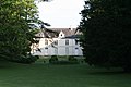
L'Audonnière Castle


literature
- Le Patrimoine des Communes de la Vienne. Volume 1, Flohic Editions, Paris 2002, ISBN 2-84234-128-7 , pp. 324-332.