Épieds (Aisne)
| Épieds | ||
|---|---|---|
|
|
||
| region | Hauts-de-France | |
| Department | Aisne | |
| Arrondissement | Château-Thierry | |
| Canton | Château-Thierry | |
| Community association | Region de Château-Thierry | |
| Coordinates | 49 ° 6 ′ N , 3 ° 27 ′ E | |
| height | 125-222 m | |
| surface | 18.66 km 2 | |
| Residents | 392 (January 1, 2017) | |
| Population density | 21 inhabitants / km 2 | |
| Post Code | 02400 | |
| INSEE code | 02280 | |
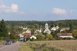
 View of Épieds |
||
Épieds is a French municipality with 392 inhabitants (as of January 1 2017) in the region of Hauts-de-France . It is located in the Aisne department , in the Château-Thierry arrondissement . Épieds belongs to the canton of Château-Thierry and the municipality association Région de Château-Thierry . The inhabitants are called Spicariens .
geography
Épieds is located about 85 kilometers east-northeast of Paris . Épieds is surrounded by the neighboring communities of Brécy in the north and northwest, Coincy in the north, Beuvardes in the east and northeast, Chartèves in the east and southeast, Mont-Saint-Père in the southeast, Verdilly in the south and Bézu-Saint-Germain in the west.
The A4 autoroute runs through the municipality .
Population development
| year | 1962 | 1968 | 1975 | 1982 | 1990 | 1999 | 2006 | 2013 |
| Residents | 206 | 192 | 175 | 232 | 332 | 332 | 350 | 389 |
| Source: Cassini and INSEE | ||||||||
Attractions
- Saint-Médard collegiate church, Monument historique since 1920
- Moucheton Castle, Monument historique since 1992
Web links
Commons : Épieds - collection of images, videos and audio files

