
Reichsautobahn Berlin – Königsberg
| Basic data | ||||||||||||||||||||||||||||||||||||||||||||||||||||||||||||||||||||||||||||||||||||||||||||||||||||||||||||||||||||||||||||||||||||||||||||||||||||||||||||||||||||||||||||||||||||||||||||||||||||||||||||||||||||||||||||||||||||||||||||||||||||||||||||||||||||||||||||||||||||||||||||||||
|---|---|---|---|---|---|---|---|---|---|---|---|---|---|---|---|---|---|---|---|---|---|---|---|---|---|---|---|---|---|---|---|---|---|---|---|---|---|---|---|---|---|---|---|---|---|---|---|---|---|---|---|---|---|---|---|---|---|---|---|---|---|---|---|---|---|---|---|---|---|---|---|---|---|---|---|---|---|---|---|---|---|---|---|---|---|---|---|---|---|---|---|---|---|---|---|---|---|---|---|---|---|---|---|---|---|---|---|---|---|---|---|---|---|---|---|---|---|---|---|---|---|---|---|---|---|---|---|---|---|---|---|---|---|---|---|---|---|---|---|---|---|---|---|---|---|---|---|---|---|---|---|---|---|---|---|---|---|---|---|---|---|---|---|---|---|---|---|---|---|---|---|---|---|---|---|---|---|---|---|---|---|---|---|---|---|---|---|---|---|---|---|---|---|---|---|---|---|---|---|---|---|---|---|---|---|---|---|---|---|---|---|---|---|---|---|---|---|---|---|---|---|---|---|---|---|---|---|---|---|---|---|---|---|---|---|---|---|---|---|---|---|---|---|---|---|---|---|---|---|---|---|---|---|---|---|---|---|---|---|---|---|---|---|---|---|---|---|---|---|---|---|---|---|---|---|---|---|---|---|---|---|---|---|---|---|---|---|---|
 Planned route between Stettin and Königsberg, according to the Westpreußischer Zeitung, January 1939 |
||||||||||||||||||||||||||||||||||||||||||||||||||||||||||||||||||||||||||||||||||||||||||||||||||||||||||||||||||||||||||||||||||||||||||||||||||||||||||||||||||||||||||||||||||||||||||||||||||||||||||||||||||||||||||||||||||||||||||||||||||||||||||||||||||||||||||||||||||||||||||||||||
| overall length | about 500 km | |||||||||||||||||||||||||||||||||||||||||||||||||||||||||||||||||||||||||||||||||||||||||||||||||||||||||||||||||||||||||||||||||||||||||||||||||||||||||||||||||||||||||||||||||||||||||||||||||||||||||||||||||||||||||||||||||||||||||||||||||||||||||||||||||||||||||||||||||||||||||||||||
| former state | ||||||||||||||||||||||||||||||||||||||||||||||||||||||||||||||||||||||||||||||||||||||||||||||||||||||||||||||||||||||||||||||||||||||||||||||||||||||||||||||||||||||||||||||||||||||||||||||||||||||||||||||||||||||||||||||||||||||||||||||||||||||||||||||||||||||||||||||||||||||||||||||||
| today's states | ||||||||||||||||||||||||||||||||||||||||||||||||||||||||||||||||||||||||||||||||||||||||||||||||||||||||||||||||||||||||||||||||||||||||||||||||||||||||||||||||||||||||||||||||||||||||||||||||||||||||||||||||||||||||||||||||||||||||||||||||||||||||||||||||||||||||||||||||||||||||||||||||
| status |
The following roads today run (partially) on the former Reichsautobahn Berlin – Königsberg: |
|||||||||||||||||||||||||||||||||||||||||||||||||||||||||||||||||||||||||||||||||||||||||||||||||||||||||||||||||||||||||||||||||||||||||||||||||||||||||||||||||||||||||||||||||||||||||||||||||||||||||||||||||||||||||||||||||||||||||||||||||||||||||||||||||||||||||||||||||||||||||||||||
| State of development |
|
|||||||||||||||||||||||||||||||||||||||||||||||||||||||||||||||||||||||||||||||||||||||||||||||||||||||||||||||||||||||||||||||||||||||||||||||||||||||||||||||||||||||||||||||||||||||||||||||||||||||||||||||||||||||||||||||||||||||||||||||||||||||||||||||||||||||||||||||||||||||||||||||
|
||||||||||||||||||||||||||||||||||||||||||||||||||||||||||||||||||||||||||||||||||||||||||||||||||||||||||||||||||||||||||||||||||||||||||||||||||||||||||||||||||||||||||||||||||||||||||||||||||||||||||||||||||||||||||||||||||||||||||||||||||||||||||||||||||||||||||||||||||||||||||||||||
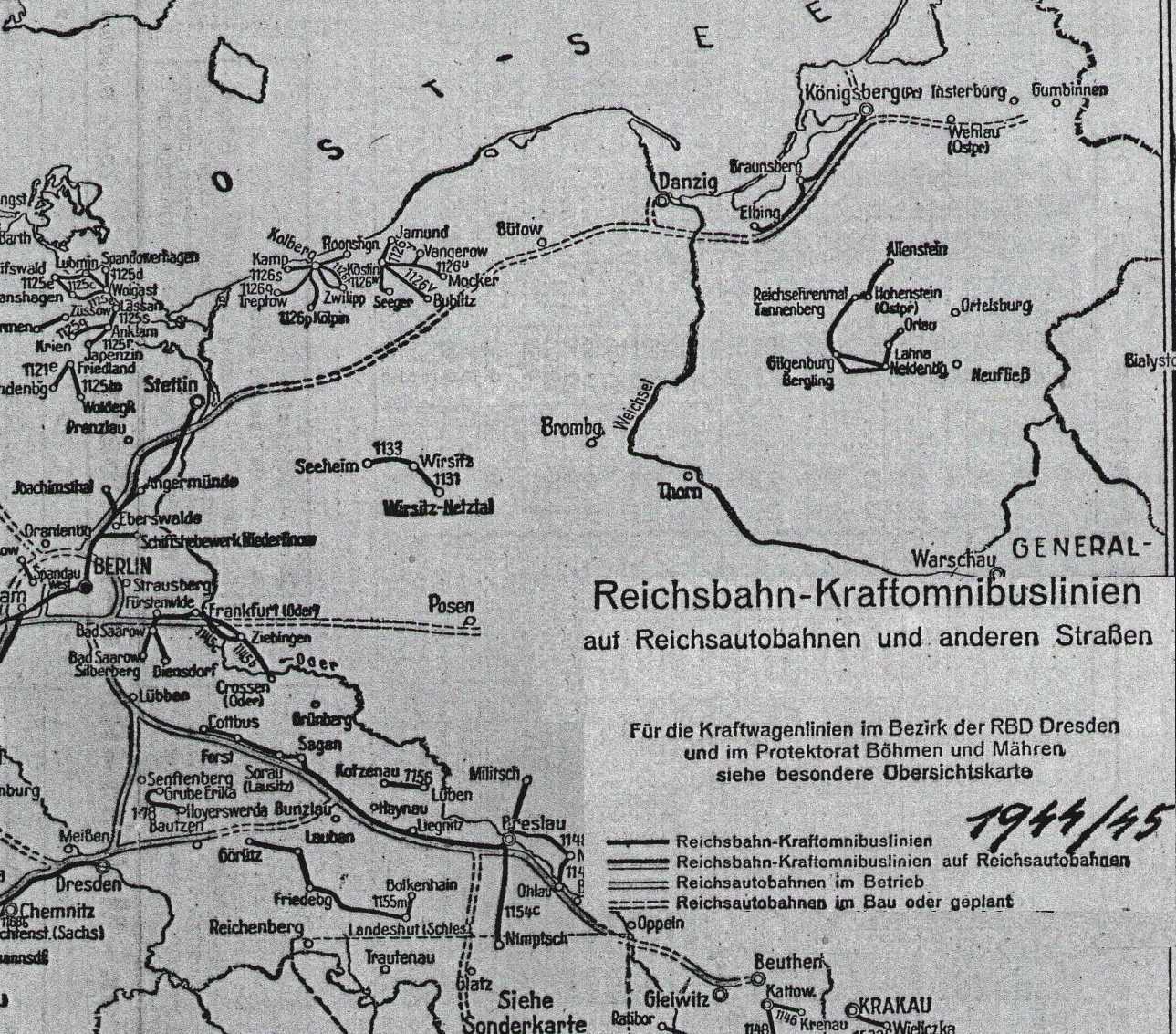
Reichsautobahn Berlin – Königsberg was the official name for a partially implemented Reichsautobahn project in the 1930s and 1940s. The motorway had to be led across the Polish corridor , among other things , which was an obstacle. The two-lane motorway route from Berlin to Stettin (today's A 11 / A 6 ) was continuously passable from 1936, in East Prussia the single-lane section from Elbing to Königsberg was opened in 1938 . There it ended at Reichsstraße 128 , a few kilometers before the Pregelbrücke Palmburg - once Germany's largest reinforced concrete girder bridge.
After the Second World War , the parts were in the areas of the Soviet Zone or GDR , the People's Republic of Poland and the Kaliningrad area of the Russian SFSR of the Soviet Union .
history
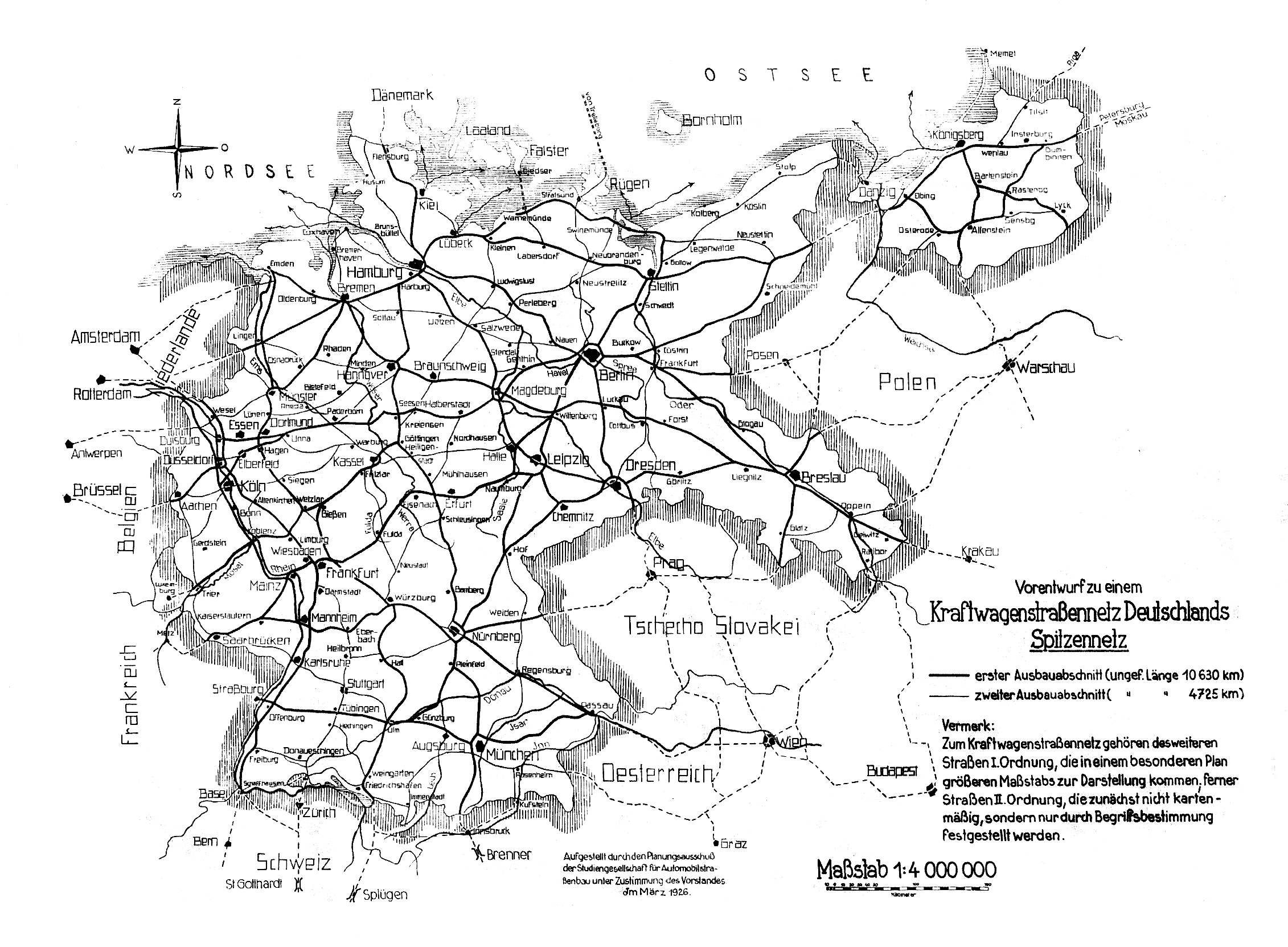
The mass motorization of later decades was not foreseeable when in March 1926 the “ Study Society for Automobile Road Construction (STUFA)” (later HaFraBa ) presented a “preliminary design for a German motor vehicle road network”, which in the first expansion phase would be a network of over 10,630 km in length provided. Roads in neighboring countries were also shown in dashed lines (through Austria, Czechoslovakia and Poland). Metropolises such as Vienna or Prague were included, but on the other hand routes with a transit character were also provided, which corresponded less to the circumstances of the respective countries than to German needs. Two west-east connections have been drawn on Polish territory, one via Posen and one further north in the Polish corridor .
A connection from the western to the eastern border of the German Reich , which also connected Berlin and Königsberg, was designated as a trunk road (FVS) 1 in 1932 (from 1934 Reichsstrasse 1 ). After the Nazi seizure of power in 1933, the idea of building the autobahn was taken up and the Reich autobahns to be created were propagated as “Fuehrer's roads”, although the level of motorization in Germany, not least due to the global economic crisis , was still very low. However, the population was given the prospect of the KdF-Wagen as an affordable automobile, and the Reichsbahn's bus and coach transport should use the autobahn. As early as September 1933, the plan for a basic motorway network was presented, which also contained the "main line C", which should not only connect Nuremberg via Bayreuth and Leipzig with the capital, but also included the Berlin - Stettin - Königsberg route .
The Polish government always refused to build a new route for transit traffic to East Prussia, both over the Polish territory in the corridor and over the area of the Free City of Danzig , where Poland and the League of Nations had extensive say. Secretly, however, work had been going on since 1935 on the problem of the Stettin – East Prussia motorway connection, also via the area of the Free State of Danzig, and the planning was completed by 1936. The narrowest section of the corridor between Bütow in Pomerania and the westernmost extension of the Danzig area near Mariensee was chosen for the transit route. The alignment also had to be based on the local waters.
A map with the 6900 km basic network of the Reich government from May 1934 and with the road surfaces to be completed in 1935 was published on Labor Day on May 1, 1935. In it, the sections Berlin – Stettin and Elbing – Königsberg were marked as being under construction, of which the Bernau – Angermünde section and a section near Königsberg were supposed to be passable in 1935. Through Pomerania a relatively schematic and straight line was recorded via Labes , Polzin , Bublitz and Bütow and after the gap in the corridor in the Danzig area to Elbing.


First, in 1935, the work on the Berlin – Stettin line was awarded, so that on April 4, 1936, the Stettiner Dreieck section to Joachimsthal and on September 27, 1936 the section to Stettin-Süd was completed with two lanes. After the completion of the Oder bridges near Stettin, the section up to the junction Hornskrug / Bäderstraße was opened to traffic on July 31, 1937. Within East Prussia, the motorway from Elbing to Königsberg was completed as a single lane between 1936 and 1938.
A map from August 15, 1938 shows that the planned route of the Reichsautobahn Stettin – Königsberg was concretized both in Pomerania and in the Danzig area and mostly ran more south than previously planned.
After the so-called smashing of the rest of Czech Republic by Germany in March 1939 and the annexation of the Memelland , Hitler's demands for an extraterritorial rail and motorway connection through the Polish corridor were rejected by Poland.
Although general building bans on Reichsautobahn were imposed on August 4, October 2 (after the German invasion of Poland ) and November 1, 1939, the award of further work on the Stettin – Bärwalde route was not included. However, due to the course of the war in 1942, only the section between the junction Hornskrug / Bäderstraße and Stargard in Pomerania could be opened to traffic by the completion of the southern carriageway until the construction work was finally stopped . In the Stargard section in Pommern - Landesstraße 20 , the southern carriageway was only expanded after the war and the Stargard junction in Pommern / Freienwalde was rebuilt. The original junction for Freienwalde was planned 4 km further east.
On the further route (55) to Bärwalde , on the northern section (route 93) via Baldenburg to Rummelsburg , a section between Bütow and Berent and a further section south of Tiegenhof between the Linawa and Schwente rivers , earthworks and clearing were carried out as well as some Bridge foundations and drains built.
Consequences of the war and the Cold War
The East Prussian Operation (1945) also affected the completed sections of the motorway. In East Prussia, for example, the bridge over the Pregel , which had been built in the course of a future bypass motorway around Königsberg, was blown up by the Wehrmacht because of the advance of the Red Army , as was the Oder bridges near Stettin . Later these structures were partially rebuilt by the People's Republic of Poland and the Soviet Union .
As a result of the resolutions of the Tehran Conference , the Yalta Conference and the Potsdam Conference , large parts of the areas over which the Reichsautobahn Berlin – Königsberg ran or should run fell to Poland and the Soviet Union. Only the section between Berlin and the new German-Polish border near Stettin was in the Soviet occupation zone of Germany. The expressway network plans of Poland from 1945, 1946 and 1963 still provided for a connection between Szczecin ( Stettin ) and Gdańsk ( Danzig ), which was similar to the plans before 1945. The plan from 1971 still contained a Szczecin – Gdańsk expressway, but further north via Koszalin ( Köslin ). A year later, this connection was no longer in the network plan. In 1976 and 1985 the route was again included in the plans. However, it did not come to fruition until the political change in Poland.
The situation was similar with the recommissioning of the Elbląg ( Elbing ) - Kaliningrad ( Königsberg ) line. The border between the parts of East Prussia, which belonged to Poland from 1945, and the Kaliningrad Oblast , which belongs to the Soviet Union, was closed, so that the Elbląg – Kaliningrad motorway was interrupted. The Polish network plans from 1945 and 1946 still integrated the line into the overall network. In 1963 the route was canceled. For this, the 1971 plan provided for approval for the year 2000. However, the connection was missing again in all other network plans.
With the political change and the associated increase in the number of cars and road freight traffic, there was a need for efficient east-west connections. The 1993 network plan already provided for a Szczecin – Gdańsk – Elbląg – Kaliningrad expressway.
present

The sections of the Reichsautobahn Berlin – Königsberg located in Germany between the Barnim triangle and the Pomellen / Kołbaskowo ( Kolbitzow ) border crossing are now run as Federal Motorway 11 .
The subsequent section from the Pomellen / Kołbaskowo border crossing to Kijewo ( rose garden ) is dedicated as the A6 autostrada . In the further course to its provisional end at Chociwel / Freienwalde, where the road joins the DK 20 , the road is only a semi-freeway, one lane in each direction, and not separated from each other, although the dam and the bridges make up a complete freeway are designed. The section is now dedicated as DW 142 . On a small part of the former Reichsautobahn between Elbląg ( Elbing ) and Kaliningrad ( Königsberg ) the S 7 from Warsaw to Gdańsk ( Danzig ) runs south of Elbląg . The reconstruction of the line has already been fully completed on the Polish side ( S 22 ). The former motorway is also being used again in the Russian Oblast of Kaliningrad ( R 516 ). The border crossing Mamonowo II - Grzechotki ( Heiligenbeil - Rehfeld ) between Russia and Poland was opened in December 2010.
gallery

Polish A6 towards Germany, shortly before the Kołbaskowo exit (formerly Stettin- Süd) in 2005

Russian R 516 at Kornewo (Zinten) 2006 with a soda bridge

Russian R 516 shortly before Kaliningrad (Koenigsberg) 2008


_2006.jpg)


See also
- Unfinished structures
- Reichsautobahn Vienna – Breslau
- Route 24
- Route 77
- Route 85
- Federal motorway 46
Web links
- Autobahn-online.de
- Private Polish website about the Reichsautobahn Berlin – Königsberg with maps from 1937 and 1944
- landkartenarchiv.de: REICHSAUTOBAHNATLAS Published by the General Inspector for German Roads Established: 1938
- Lines 54 and 55 (German-Polish border Freienwalde (Chociwel)) (PDF; 1.8 MB)
Remarks
- ^ Herberg W .: The Pregelbrücke Palmburg, Germany's largest reinforced concrete girder bridge . In: Concrete and reinforced concrete construction . 47, No. 7, 1952.
- ↑ On the two private websites from Poland mentioned under "Weblinks", the sections are also referred to as Berlinka (Polish for: Die Berlinerin , Die aus Berlin ). The Wikisłownik (the Polish Wiktionary ), this name unknown for a highway. Possibly it is a new word created by the website operator, which was only established by Wikipedia .
- ↑ autobahnatlas-online.de: Original network plan from 1926 (motor vehicle road network) - preliminary draft for a motor vehicle road network in Germany from 1926. Prepared by the planning committee of STUFA (study society for automotive road construction).
- ^ Motorway construction in Germany - prehistory and start of construction
- ^ Karl Lärmer: Autobahn construction in Germany 1933 to 1945. Berlin 1975, p. 122 mw N.
- ↑ Reichsautobahn construction in Gdansk (report), in: The Road, No. 18/19/1939, p 58
- ^ Karl Lärmer: Autobahn construction in Germany 1933 to 1945. P. 103 mw N.
- ↑ Map with the 6900 km basic network and its supplementary lines as well as the status of planning and construction work on May 1, 1935
- ↑ interior ministry.bayern.de: History of motorway construction from a Bavarian point of view ( memento from August 2, 2012 in the web archive archive.today ) with the basic network of the Reichsautobahn ( memento from April 6, 2015 in the Internet Archive )
- ↑ Autobahn history e. V.
- ↑ autobahn-online.de - route openings
- ↑ Overview of the Reichsautobahn network from August 15, 1938
- ^ Karl Lärmer: Autobahn construction in Germany 1933 to 1945 , pp. 127, 133 and 134 mw N.
- ↑ autobahn-online.de - route openings
- ↑ Numbering of the Reichsautobahn according to the main cost estimates
- ↑ Germany 1: 25,000 aerial plan work of the German Reich, sheet number: 1880, photo: May 1941
- ↑ OpenStreetMap: Reichsautobahn route 93, Danzig-Elbing
- ^ Line 55, section Freienwalde – Bärwalde (Polish)
- ↑ Route 93, section Bärwalde – Berent (Polish)
- ↑ Eugeniusz Buszma: "Przegląd komunikacyjny" No. 3–4 September – October 1945 (Polish) ( Memento from December 18, 2007 in the Internet Archive )
- ↑ Eugeniusz Buszma: "Drogowiec" No. 1 and 2 from 1946 (Polish) ( Memento from December 18, 2007 in the Internet Archive )
- ↑ Eugeniusz Buszma: "Drogowiec" No. 8 from 1971 (Polish) ( Memento from December 18, 2007 in the Internet Archive )
- ↑ Decision of the Regional Council of January 23, 1976 (Polish) ( Memento of September 27, 2007 in the Internet Archive )
- ^ Decision of the regional council of June 14, 1985 (Polish) ( Memento of December 18, 2007 in the Internet Archive )
- ^ Resolution of the Council of Ministers of September 28, 1993 (Polish)
- ↑ New checkpoint: Kaliningrad is getting closer to Europe