Cauroir
| Cauroir | ||
|---|---|---|

|
|
|
| region | Hauts-de-France | |
| Department | North | |
| Arrondissement | Cambrai | |
| Canton | Caudry | |
| Community association | Cambrai | |
| Coordinates | 50 ° 11 ′ N , 3 ° 18 ′ E | |
| height | 51-82 m | |
| surface | 5.61 km 2 | |
| Residents | 570 (January 1, 2017) | |
| Population density | 102 inhabitants / km 2 | |
| Post Code | 59400 | |
| INSEE code | 59141 | |
| Website | http://www.cauroir.fr/ | |
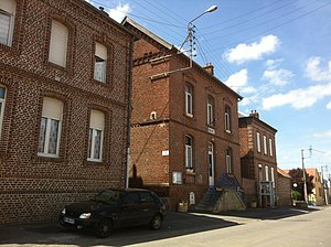
 Town Hall (Mairie) of Cauroir |
||
Cauroir is a French municipality with 570 inhabitants (as of January 1 2017) in the department of Nord in the region of Hauts-de-France . It belongs to the Arrondissement Cambrai , the Communauté d'agglomération de Cambrai and the Canton of Caudry (until 2015: Canton Cambrai-Est ). The inhabitants are called Cauroisiens .
geography
Cauroir is about four kilometers east of the city center of Cambrai . Neighboring communities are Escaudœuvres in the north and north-west, Cagnoncles in the north and east, Carnières in the east and south-east, Estourmel in the south and south-east, Awoingt in the south and south-west and Cambrai in the west.
Population development
| year | 1962 | 1968 | 1975 | 1982 | 1990 | 1999 | 2006 | 2013 |
| Residents | 502 | 580 | 629 | 637 | 563 | 515 | 544 | 592 |
| Source: Cassini and INSEE | ||||||||
Personalities
- Yvonne Pagniez (1896–1981), writer, journalist and resistance fighter
Attractions
- Saint-Léger church, built in 1888 (see also: List of Monuments historiques in Cauroir )
- Saint-Roch Chapel, built in 1884
literature
- Le Patrimoine des Communes du Nord. Flohic Editions, Volume 1, Paris 2001, ISBN 2-84234-119-8 , pp. 387-388.
Web links
Commons : Cauroir - collection of images, videos and audio files

