
Pommereuil
| Pommereuil | ||
|---|---|---|
_Nord-France.svg)
|
|
|
| region | Hauts-de-France | |
| Department | North | |
| Arrondissement | Cambrai | |
| Canton | Le Cateau-Cambrésis | |
| Community association | Caudrésis et Catésis | |
| Coordinates | 50 ° 7 ' N , 3 ° 36' E | |
| height | 91-153 m | |
| surface | 6.45 km 2 | |
| Residents | 770 (January 1, 2017) | |
| Population density | 119 inhabitants / km 2 | |
| Post Code | 59360 | |
| INSEE code | 59465 | |
 Local map |
||

Pommereuil is a municipality with 770 inhabitants (at January 1, 2017) in the French department of Nord in the region of Hauts-de-France . It belongs to the canton of Le Cateau-Cambrésis in the Arrondissement of Cambrai . It borders on Forest-en-Cambrésis to the north, Ors to the east, Bazuel to the south and Le Cateau-Cambrésis to the west . The residents call themselves Pommereullois .
The former Route nationale 359 connects Pommereuil with Le Cateau-Cambrésis and Landrecies .
The nearest train station, served by the SNCF , is in Le Cateau-Cambrésis . From there, a 337 bus runs via Pommereuil to Mazinghien .
Population development
| year | 1962 | 1968 | 1975 | 1982 | 1990 | 1999 | 2008 | 2013 |
|---|---|---|---|---|---|---|---|---|
| Residents | 730 | 701 | 756 | 707 | 752 | 717 | 749 | 782 |
Attractions
- British war cemetery
- French military cemetery
- Saint-Michel church
- War memorial

Mairie Pommereuil
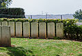
British war cemetery

French military cemetery

Saint-Michel church


literature
- Le Patrimoine des Communes du Nord. Flohic Editions, Volume 1, Paris 2001, ISBN 2-84234-119-8 , pp. 529-531.
Web links
Commons : Pommereuil - collection of images, videos and audio files
- Monuments historiques (objects) in Pommereuil in the base Palissy of the French Ministry of Culture