
Ligny-en-Cambrésis
| Ligny-en-Cambrésis | ||
|---|---|---|
_Nord-France.svg)
|
|
|
| region | Hauts-de-France | |
| Department | North | |
| Arrondissement | Cambrai | |
| Canton | Le Cateau-Cambrésis | |
| Community association | Caudrésis et Catésis | |
| Coordinates | 50 ° 6 ' N , 3 ° 23' E | |
| height | 83-144 m | |
| surface | 8.79 km 2 | |
| Residents | 1,894 (January 1, 2017) | |
| Population density | 215 inhabitants / km 2 | |
| Post Code | 59191 | |
| INSEE code | 59349 | |
| Website | www.ligny-en-cambresis.fr | |
 Town hall ( Mairie ) of Ligny-en-Cambrésis |
||

Ligny-en-Cambrésis is a French commune with 1,894 inhabitants (as of January 1 2017) in the department of Nord in the region of Hauts-de-France . It belongs to the Arrondissement of Cambrai and the canton of Le Cateau-Cambrésis (until 2015: canton of Clary ). The inhabitants are called Lignysiens .
geography
Ligny-en-Cambrésis is about 13 kilometers southeast of Cambrai . Ligny-en-Cambrésis is surrounded by the neighboring communities of Fontaine-au-Pire in the north, Caudry in the northeast, Montigny-en-Cambrésis in the east and southeast, Clary and Caullery in the south, Walincourt-Selvigny in the southwest and Haucourt-en-Cambrésis in the West.
Population development
| year | 1962 | 1968 | 1975 | 1982 | 1990 | 1999 | 2006 | |
| Residents | 2.112 | 2.012 | 2,107 | 1,889 | 1,835 | 1,658 | 1,687 | |
| Source: Cassini, EHESS and INSEE | ||||||||
Attractions
- Saint Martin Church
- Ligny Castle, originally built as a castle in the 9th century, numerous renovations, today a hotel
- British military cemetery
- Pattyn Brewery

Saint Martin Church
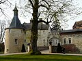
Ligny Castle


literature
- Le Patrimoine des Communes du Nord. Flohic Editions, Volume 1, Paris 2001, ISBN 2-84234-119-8 , pp. 557-558.
Web links
Commons : Ligny-en-Cambrésis - collection of images, videos and audio files