
Haynecourt
| Haynecourt | ||
|---|---|---|
_Nord-France.svg)
|
|
|
| region | Hauts-de-France | |
| Department | North | |
| Arrondissement | Cambrai | |
| Canton | Cambrai | |
| Community association | Cambrai | |
| Coordinates | 50 ° 13 ' N , 3 ° 10' E | |
| height | 58-81 m | |
| surface | 5.92 km 2 | |
| Residents | 321 (January 1, 2017) | |
| Population density | 54 inhabitants / km 2 | |
| Post Code | 59268 | |
| INSEE code | 59294 | |
| Website | http://www.haynecourt.fr/ | |
 Haynecourt Town Hall |
||

Haynecourt is a commune of 321 inhabitants (as of January 1 2017) in Nord in the region of Hauts-de-France ; it belongs to the Arrondissement of Cambrai and the canton of Cambrai (until 2015: canton of Cambrai-Ouest ). The inhabitants are called Fontenois .
geography
Haynecourt is about five kilometers northwest of Cambrai . Haynecourt is surrounded by the neighboring communities of Épinoy in the north, Sancourt in the east, Sailly-lez-Cambrai in the south-east, Raillencourt-Sainte-Olle in the south, Bourlon in the south-west, Marquion in the west and south-west and Sauchy-Lestrée in the west and north-west. In the northern municipal area is part of the base aérienne 103 Cambrai-Épinoy military airfield .
history
Haynecourt was directly in the front zone of the so-called Hindenburg Line and was almost completely destroyed in the First World War .
Haynecourt was part of the Communauté de communes de l'Ouest Cambrésis from 1993 to 2014 .
Population development
| year | 1962 | 1968 | 1975 | 1982 | 1990 | 1999 | 2006 | 2012 |
| Residents | 602 | 568 | 323 | 369 | 442 | 276 | 553 | 531 |
| Source: Cassini and INSEE | ||||||||
Attractions
- Saint-Martin Church (see also: List of Monuments historiques in Haynecourt )
- British military cemetery
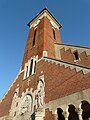
Saint Martin Church

British military cemetery


literature
- Le Patrimoine des Communes du Nord. Flohic Editions, Volume 1, Paris 2001, ISBN 2-84234-119-8 , pp. 397-398.