Raillencourt-Sainte-Olle
| Raillencourt-Sainte-Olle | ||
|---|---|---|

|
|
|
| region | Hauts-de-France | |
| Department | North | |
| Arrondissement | Cambrai | |
| Canton | Cambrai | |
| Community association | Cambrai | |
| Coordinates | 50 ° 12 ′ N , 3 ° 10 ′ E | |
| height | 45-86 m | |
| surface | 7.09 km 2 | |
| Residents | 2,238 (January 1, 2017) | |
| Population density | 316 inhabitants / km 2 | |
| Post Code | 59554 | |
| INSEE code | 59488 | |
| Website | http://www.raillencourt.fr/ | |
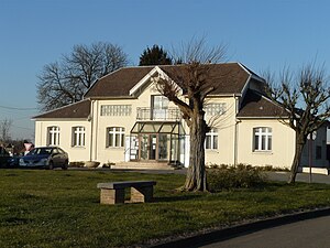
 Raillencourt-Sainte-Olle Town Hall |
||
Raillencourt-Sainte-Olle is a French municipality with 2238 inhabitants (as of January 1 2017) in the department of Nord in the region of Hauts-de-France ; it belongs to the Arrondissement of Cambrai and the canton of Cambrai (until 2015: canton of Cambrai-Ouest ). The inhabitants are called Raillencourtois .
geography
Raillencourt-Sainte-Olle is northwest of Cambrai . Raillencourt-Sainte-Olle is surrounded by the neighboring communities of Haynecourt , Sailly-lez-Cambrai and Sancourt in the north, Tilloy-lez-Cambrai in the northeast, Neuville-Saint-Rémy in the east, Cambrai in the east and southeast, Fontaine-Notre-Dame in the South and Bourlon to the west and south-west.
Autoroute A2 leads through the municipality .
history
In 1974 Raillencourt and Sainte-Olle were merged.
Population development
| year | 1962 | 1968 | 1975 | 1982 | 1990 | 1999 | 2006 | 2012 |
| Residents | 1,499 | 1,891 | 1,826 | 2,201 | 2,220 | 2,280 | 2,383 | 2,347 |
Attractions
- Saint-Nicolas church in Sainte-Olle
- Notre-Dame-de-Lourdes church in Raillencourt (see also: List of Monuments historiques in Raillencourt-Sainte-Olle )
- Three British military cemeteries
literature
- Le Patrimoine des Communes du Nord. Flohic Editions, Volume 1, Paris 2001, ISBN 2-84234-119-8 , pp. 409-410.


