
Romeries
| Romeries | ||
|---|---|---|
_Nord-France.svg)
|
|
|
| region | Hauts-de-France | |
| Department | North | |
| Arrondissement | Cambrai | |
| Canton | Caudry | |
| Community association | Pays Solemois | |
| Coordinates | 50 ° 12 ' N , 3 ° 32' E | |
| height | 91-126 m | |
| surface | 6.01 km 2 | |
| Residents | 450 (January 1, 2017) | |
| Population density | 75 inhabitants / km 2 | |
| Post Code | 59730 | |
| INSEE code | 59506 | |

Romeries is a commune in the French department of Nord in the region of Hauts-de-France . It belongs to the canton of Caudry in the Arrondissement of Cambrai . It borders on Vertain to the north-west, Escarmain , Beaudignies and Neuville-en-Avesnois to the north-east, Vendegies-au-Bois to the south-east, Beaurain to the south and Solesmes to the south-west .
The former Route nationale 342 leads via Romeries.
Population development
| year | 1962 | 1968 | 1975 | 1982 | 1990 | 1999 | 2008 | 2013 |
|---|---|---|---|---|---|---|---|---|
| Residents | 484 | 490 | 492 | 407 | 385 | 350 | 431 | 434 |
Attractions
- Saint-Humbert Church
- chapel
- War memorial
- Military cemetery

Saint-Humbert Church

chapel
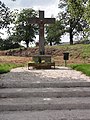
Floor cross
_%C3%A9glise,_fa%C3%A7ade.jpg)
_chapelle.jpg)
_calvaire_D942.jpg)
literature
- Le Patrimoine des Communes du Nord. Flohic Editions, Volume 2, Paris 2001, ISBN 2-84234-119-8 , pp. 1500-1501.
Web links
Commons : Romeries - collection of images, videos and audio files
- Monuments historiques (objects) in Romeries in the base Palissy of the French Ministry of Culture