Dětkovice
| Dětkovice | ||||
|---|---|---|---|---|
|
||||
| Basic data | ||||
| State : |
|
|||
| Region : | Jihomoravský kraj | |||
| District : | Vyškov | |||
| Area : | 497 ha | |||
| Geographic location : | 49 ° 16 ' N , 17 ° 9' E | |||
| Height: | 274 m nm | |||
| Residents : | 274 (Jan. 1, 2019) | |||
| Postal code : | 683 24 | |||
| License plate : | B. | |||
| traffic | ||||
| Street: | Ivanovice na Hané - Morkovice-Slížany | |||
| structure | ||||
| Status: | local community | |||
| Districts: | 1 | |||
| administration | ||||
| Mayor : | Jan Vrána (as of 2010) | |||
| Address: | Dětkovice 76 683 23 Ivanovice na Hané |
|||
| Municipality number: | 592978 | |||
| Website : | www.obecdetkovice.cz | |||
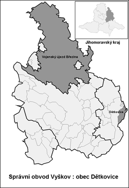
| Location of Dětkovice in the Vyškov district | ||||

|
||||
Dětkovice (German Dietkowitz ) is a municipality in the Czech Republic . It is located six kilometers northwest of Morkovice-Slížany and belongs to the Okres Vyškov .
geography
Dětkovice is located in the northern foothills of the Litenčické vrchy at the transition to the Upper Moravian Depression ( Hornomoravský úval ). The place stretches across the basin of the Dětkovický brook. The Lopata (429 m) rises to the south.
Neighboring towns are Dřevnovice , Těšice and Tištín in the north, Koválovice u Tištína in the Northeast, Osíčany, Okluky and Prasklice the east, Pačlavice the southeast, Zdravá Voda, Lhota, Boří za Zdravou Vodou and Vanovsko in the south, Orlovice and Moravské Málkovice in the southwest and Švábenice in the north-west.
history
The village was first mentioned in writing in 1311 when Vítek von Schwabenitz, together with his son Jan, left one and a half hubs of the village to the Augustinian monastery on the Zderaz near Prague for the lifelong usufruct of the matron Lukarda, a protégé of Vítek's first wife Anežka. The Lords of Schwabenitz only held a small portion of the village, the majority was owned by the Vladiken von Dětkovice. They acquired the entire village at the beginning of the 15th century. In 1466 Ondřej von Zástřizl and Dětkovice assigned the village to his wife Hedwig. In the same year Dětkovice became the seat of Wilhelm von Zástřizl. Tobias von Obřanské Hory acquired part of the property at the end of the 15th century. He sold the 1503 to Nikolaus Zendler von Hof. In 1511 Vilém, Výšek and Jan Hynek von Veselice bought this share including the farm. Then the whole of Dětkovice became subordinate to the Pačlavice estate. The Dětkovice farm was expanded into a large estate in 1846.
After the abolition of patrimonial Dětkovice formed from 1850 a municipality in the Kremsier district administration . In 1870 and 1874 the village was ravaged by major fires. In 1885 cholera broke out. At the end of the 19th century the place was called Dědkovice . In 1887 a village school was set up in Dětkovice, before lessons were held in Schwabenitz. In 1908 the two-class lessons were started, from 1945 onwards there was only one class in Dětkovice. Electrification took place in 1927. In the course of forced collectivization, JZD Dětkovice was established in 1950 . In the same year the village was reclassified in the Okres Vyškov . In 1976 it was incorporated into Švábenice. In 1990 Dětkovice broke away and has since formed its own political municipality. Dětkovice is part of the Ivanovická brána microregion.
Community structure
No districts are shown for the municipality of Dětkovice.
Attractions
- Chapel of St. Florian on the village green, built in 1899 with the support of dean Josef Dostál
- Old school, today the seat of the municipal office
- Way of the Cross, consecrated in 1925
- Memorial to the victims of the First World War, next to the chapel
- two stone crosses at houses 98 and 104
- Natural monuments Nad Medlovickým potokem and Roznitál, southwest of the village
- Jezírko pilgrimage chapel, south of the village, built in 1889


