Kozlany u Vyškova
| Kozlany | ||||
|---|---|---|---|---|
|
||||
| Basic data | ||||
| State : |
|
|||
| Region : | Jihomoravský kraj | |||
| District : | Vyškov | |||
| Area : | 758 ha | |||
| Geographic location : | 49 ° 12 ' N , 17 ° 2' E | |||
| Height: | 315 m nm | |||
| Residents : | 357 (Jan. 1, 2019) | |||
| Postal code : | 683 41 | |||
| License plate : | B. | |||
| traffic | ||||
| Street: | Nesovice - Bohdalice | |||
| structure | ||||
| Status: | local community | |||
| Districts: | 1 | |||
| administration | ||||
| Mayor : | Roman Vaculčík (as of 2010) | |||
| Address: | Kozlany 8 683 41 Bohdalice |
|||
| Municipality number: | 550108 | |||
| Website : | www.kozlany.eu | |||
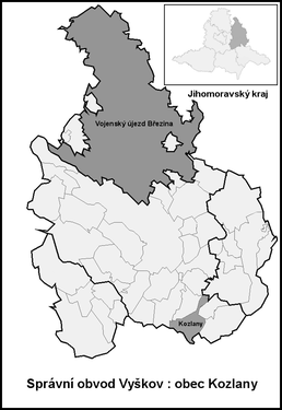
| Location of Kozlany in the Vyškov district | ||||

|
||||
Kozlany (German Koslan , formerly Kozlan ) is a municipality in the Czech Republic . It is located nine kilometers south of Vyškov and belongs to the Okres Vyškov .
geography
Kozlany is located at the northwestern foot of the Litenčické vrchy in the basin of the Rostěnický creek. To the north rises the Holý kopec (374 m), in the east the Homole (336 m) and southwest of the Malý Povětrník (316 m) and Větrník (394 m).
Neighboring towns are Bohdalice and Vážany in the north, Pavlovice in the Northeast, Stare Hvězdlice the east, Nové Hvězdlice , Komorov, Uhřice and Roštoutky the southeast, Šardičky and Kojátky in the south, Bohaté Málkovice , Letonice and Dražovice in the southwest, Podbřežice the west and Lysovice and Kučerov in the north-west.
history
Kozlany was first mentioned in a document in 1360 when Vladike Svatoch von Nezamyslice signed the income from two hubs of the village to his son-in-law Racek von Bičice. In 1376 the Vladiken von Nezamyslice Kozlany sold to the Augustinian monastery of St. Thomas in Brno . The Augustinians connected Kozlany to the Hvězdlice estate and ran a farm in Kozlany. Before the Thirty Years' War Kozlany was mostly populated by Germans. As a result of the chaos of the war, the village became deserted and later the order settled Czechs. The oldest local seal comes from the middle of the 18th century.
After the abolition of patrimonial Kozlany formed from 1850 a community in the district administration Wischau . At the end of the 19th century the community had 550 inhabitants. In 1950 Kozlany was assigned to the newly formed Okres Bučovice and after its dissolution came back to Okres Vyškov at the beginning of 1961. In 1976 it merged with Bohdalice-Pavlovice to form the municipality of Bohdalice-Kozlany . This dissolved again in 1990. The community has had a coat of arms and a banner since 1998.
Community structure
No districts are shown for the municipality of Kozlany.
Attractions
- Chapel of St. Florian on the village green
- Lookout tower on Holý Kopec


