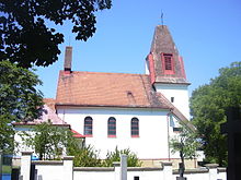
Holubice
| Holubice | ||||
|---|---|---|---|---|
|
||||
| Basic data | ||||
| State : |
|
|||
| Region : | Jihomoravský kraj | |||
| District : | Vyškov | |||
| Area : | 740 ha | |||
| Geographic location : | 49 ° 10 ' N , 16 ° 49' E | |||
| Height: | 228 m nm | |||
| Residents : | 1,298 (Jan 1, 2019) | |||
| Postal code : | 683 51 | |||
| License plate : | B. | |||
| traffic | ||||
| Street: | D 1 : Brno - Vyškov | |||
| Railway connection: | Brno – Přerov | |||
| Next international airport : | Brno-Tuřany | |||
| structure | ||||
| Status: | local community | |||
| Districts: | 1 | |||
| administration | ||||
| Mayor : | Rudolf Pěršala (as of 2010) | |||
| Address: | Holubice 61 683 51 Holubice |
|||
| Municipality number: | 550825 | |||
| Website : | www.holubiceou.cz | |||
| Location of Holubice in the Vyškov district | ||||

|
||||
Holubice (German Holubitz ) is a municipality in the Czech Republic . It is located six kilometers northwest of Slavkov u Brna and belongs to the Okres Vyškov .
geography
Holubice is located south of the Drahaner Bergland at the transition from the Thaya-Schwarza valley basin to the Wischauer Tor. The village is on the right side of the Rakovec brook. The Pracký Kopec ( Pratzeberg , 324 m) rises to the southwest . The D 1 / E50 / E462 motorway runs north of Holubice, and exit 210 Holubice is also there . The railway line from Brno to Přerov lies on the eastern edge of the village .
Neighboring towns are Pozořice and Kovalovice in the north, Kralovopolske Vážany , Slavíkovice , Stará Pošta and U nádraží in the Northeast, Velešovice the east, Slavkov u Brna in the southeast, Křenovice and Zbýšov in the south, Blažovice and Jiříkovice in the southwest, Kruh , Bedřichovice, Rohlenka and Maxlůvka in the west and Tvarožná and Sivice in the northwest.
history
Archaeological finds prove an early settlement of the area. During the construction of the motorway, a Paleolithic grave and a Lombard burial ground from the time of the Great Migration were found. Before that, there was a Celtic burial place with 77 bone graves from around 200 BC on a field in the Dílce corridor from 1930 onwards . Was found.
The first written mention of the village belonging to the Wildenberg lordship was in 1371, when Půta Šacler von Wildenberg sold the Wildenberg castle with all its accessories to Margrave Johann Heinrich . Shortly thereafter, he pledged the property to Archléb von Hrádek. The name of the village is derived from the personal name Holub . The following owners were Margrave Jobst of Moravia , from 1392 his court master Ulrich Stosch von Kaunitz auf Branitz ( Oldřich Stoš z Bránic ), from 1418 the Rosa Coeli monastery and from 1421 Jakub von Liptov. In 1532 Wilhelm von Víckov owned the goods. In 1577 Hans Gedeon Kotvrdský from Olešničky acquired Holubice. His successor Gedeon von Olešničky had a water festival built in Holubice at the end of the 16th century . In 1628 Georg Adam Falkenhan von Gloschka sold the Holubice and Kruh estates for 16,000 guilders to Cardinal Franz Seraph von Dietrichstein as the guardian of Count Leo Wilhelm von Kaunitz and added them to the Austerlitz rulership . As a result of the Thirty Years' War , Holubice was deserted and in 1718 was largely desolate . In 1742 Prussian troops invaded the village. In 1832 cholera broke out.
After the abolition of patrimonial Holubice formed with the district Kruhy from 1850 a municipality in the district administration Wischau . In the community there were two ring brick factories, two hand brick factories, a lime kiln and a gravel pit. In addition, a water mill was operated at Rakovec. There was also a windmill in the village, which was demolished in 1918. In 1855 a large fire destroyed parts of the village. Most of the livestock died in a cattle epidemic in 1863. In 1888 a train station was set up east of the village on the Brno - Přerov railway line. In the same year part of the village burned down again. Between 1903 and 1914 the cadastre of Holubice and Kruh were merged. In 1921 Kruh lost its status as a district. In the course of the land reform in 1923, František Frank acquired part of the large estate and set up a wood processing company. In 1929 the church of St. Wenceslas was consecrated as a branch church of the Pozořice parish . The rectory in Holubice was built three years later. Between 1949 and 1960 Holubice was part of Okres Slavkov and came back to Okres Vyškov after its dissolution . In 1964 Holubice was incorporated into Velešovice. The Holubice municipality has existed again since 1990.
Community structure
No districts are shown for the municipality of Holubice. The settlements Kruh ( Kruch ) and U nádraží as well as the locality Curdík belong to Holubice.
Attractions
- Branch Church of St. Wenceslas, consecrated on July 4, 1929
- Chapel of St. Gotthard
Sons and daughters of the church
- Ladislav Laco Hrdlička (* 1933), composer of Bohemian brass music
Individual evidence
- ↑ Český statistický úřad - The population of the Czech municipalities as of January 1, 2019 (PDF; 7.4 MiB)


