Hlubočany
| Hlubočany | ||||
|---|---|---|---|---|
|
||||
| Basic data | ||||
| State : |
|
|||
| Region : | Jihomoravský kraj | |||
| District : | Vyškov | |||
| Area : | 805 ha | |||
| Geographic location : | 49 ° 14 ' N , 17 ° 0' E | |||
| Height: | 273 m nm | |||
| Residents : | 487 (Jan. 1, 2019) | |||
| Postal code : | 682 01 | |||
| License plate : | B. | |||
| traffic | ||||
| Street: | Vyškov - Kučerov | |||
| structure | ||||
| Status: | local community | |||
| Districts: | 2 | |||
| administration | ||||
| Mayor : | Lubomír Bednařík (as of 2010) | |||
| Address: | Hlubočany 22 682 01 Vyškov 1 |
|||
| Municipality number: | 593036 | |||
| Website : | www.hlubocany.obec.cz | |||
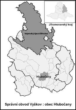
| Location of Hlubočany in the Vyškov district | ||||

|
||||
Hlubočany (German Hobitschau ) is a municipality in the Czech Republic . It is located six kilometers south of Vyškov and belongs to the Okres Vyškov .
geography
Hlubočany is located at the foot of the Litenčické vrchy in the Vyškovská brázda ( Wischauer Tor ). The village extends on both sides of the Hlubočanský brook. The D 1 motorway runs to the northwest . To the north rises the Kopaniny (356 m) and to the east the Holý Kopec ( Bald Mountain , 374 m).
Neighboring towns are Nouzka, Brňany and Dvorek in the north, Terešov , Zouvalka and Vážany in the northeast, Manerov in the east, Bohdalice and Kučerov in the southeast, Lysovice in the southwest, Rostěnice-Zvonovice in the west and Drnovice in the northwest.
history
The first documentary mention of the village took place in 1131 in the deed of transfer of ownership by Bishop Heinrich Zdik of all goods belonging to the Church of St. Peter to the newly built Wenceslas Cathedral in Olomouc . This included the goods belonging to the Pustimir Gau Nemojany , Podivice and Rostěnice, possessions in Vyškov , Dražovice , Hlubočany, Želeč , Křižanovice and the desert village of Melice near Pustimir. In another Zdik document from 1141, two preliminary works in Hlubočany were again listed. The village was established by German colonists under the Lords of Obřany in the first half of the 13th century and was one of the original 60 villages on the German-speaking Wischau language island in Moravia , most of which became Czech-speaking over the centuries through wars, epidemics and assimilation . After the Obřany family died out, Heinrich von Leipa received their goods before 1315. In 1325 he bequeathed Hobitschau to the royal monastery in Old Brno. As a result of the Thirty Years War in the second half of the 17th century, 13 of the 47 properties in the village were desolate. In 1716 the royal monastery sold the allodial property Hobitschau to the captain of the Hradian district, Bernard Anton Brawanski von Chobrzan ( Bernart Antonín Bravantský z Chobřan ). After his death in 1722, the estate was divided between his widow Johanna and five daughters. In 1727 one of the daughters, Katharina Freiin d´Albon and St. Andrée, acquired the other shares against payment from her mother and sister Josepha. Due to over-indebtedness, the estate, which had fallen to their children Eugen, Franz and Katharina, was sold by the royal tribunal in 1753 to Wenzel Count Kořenský von Terešov for 45,000 Rhenish guilders. In 1790 he had the village of Tereschau built. In 1791 Hobitschau had 372 inhabitants. Kořenský's descendants sold the Hobitschau and Tereschau estates in 1796 for 52,600 Rhenish guilders to General Ernest Count von Blankenstein. Most of the land belonged to the manor. In addition, two smaller goods in Hobitschau and Tereschau were separated from the allodial goods in the 19th century. In 1834 there were 507 people in the 79 houses in Hobitschau, 144 in Tereschau. They were German-speaking and, with the exception of six Jews in Hobitschau, all were Catholics.
After the abolition of patrimonial formed Hobitschau / Hlubočany 1850 with the hamlet Tere show a municipality in the district administration Wischau . In 1854 Hobitschau had 593 inhabitants. Since the second half of the 19th century, there has been an increased influx of Czechs into the remaining eight places on the language island. In 1858 Josef von Blankenstein sold the Hobitschau-Tereschau estate to Ernst Johann Ritter von Herring. Half of his inheritance fell to Viktor and Ernst von Herring-Frankensdorf in 1871. The single-class German elementary school in Hobitschau was inaugurated in 1876, before schooling took place in Kutscherau. In 1876 Viktor von Herring-Frankensdorf sold half of his share to Max von Gomperz and Julius von Gomperz . Subsequently, the Gomperz family acquired the entire property and Philipp Ritter von Gomperz became the sole owner in 1909. In 1919 a Czech minority school was established. In 1930 748 people lived in the village. The baroque rotunda chapel was demolished in 1932. Until the end of the Second World War, Hobitschau and Tereschau were mostly populated by Germans. Together with Rosternitz , Swonowitz , Kutscherau , Lissowitz , Gundrum and Czechs, the two villages formed a German language island with a total of 3500 residents within the Czech language area. During the German occupation , the Czech minority was evacuated from the language island villages. The proximity to the language island was also one of the main reasons for the decision made in 1940 to establish the German military training area Wischau in the Drahaner Bergland. In 1946 the German-speaking residents of Hlubočany were expelled to Germany and the place was repopulated with Czechs from the 33 villages in the Drahaner Bergland , which had been cleared for the military training area between 1941 and 1945 and whose houses had been destroyed during the exercises. In 1947 the village had 655 inhabitants. In 1952 the kindergarten was established. In 1976 Hlubočany was incorporated into Kučerov . The municipality of Hlubočany has existed again since 1990. In 1991 Hlubočany had 489 inhabitants. The village after Kučerov is parish. There is a three-class elementary school in Hlubočany.
Population development
| census | Residents | including Germans | ||
| 1880 | 600 | 496 | ||
| 1890 | 632 | 509 | ||
| 1900 | 701 | 634 | ||
| 1910 | 773 | 717 | ||
| 1921 | 746 | 510 | ||
| 1930 | 567 | 219 | ||
| 1991 | 452 | - | ||
| 2001 | 435 | - | ||
Community structure
The municipality of Hlubočany consists of the districts Hlubočany ( Hobitschau ) and Terešov ( Tereschau ) as well as the single layer Dvorek ( farm ).
Attractions
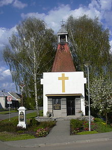
- Chapel of St. Florian on the village green, it was built in 1935 by the local architect Josef Schurius in place of a rotunda that was demolished in 1932
- Farmhouse No. 11, protected as a cultural monument
- Lookout tower on Holý Kopec
- two cast iron crosses
- Memorial to the victims of both world wars


