Tučapy u Vyškova
| Tučapy | ||||
|---|---|---|---|---|
|
||||
| Basic data | ||||
| State : |
|
|||
| Region : | Jihomoravský kraj | |||
| District : | Vyškov | |||
| Area : | 528 ha | |||
| Geographic location : | 49 ° 14 ' N , 16 ° 55' E | |||
| Height: | 260 m nm | |||
| Residents : | 590 (Jan. 1, 2019) | |||
| Postal code : | 683 01 | |||
| License plate : | B. | |||
| traffic | ||||
| Street: | Vyškov - Rousínov | |||
| Railway connection: | Brno - Přerov | |||
| structure | ||||
| Status: | local community | |||
| Districts: | 1 | |||
| administration | ||||
| Mayor : | Miloslav Brandys (as of 2010) | |||
| Address: | Tučapy 49 683 01 Rousínov u Vyškova |
|||
| Municipality number: | 593648 | |||
| Website : | www.obectucapy.cz | |||
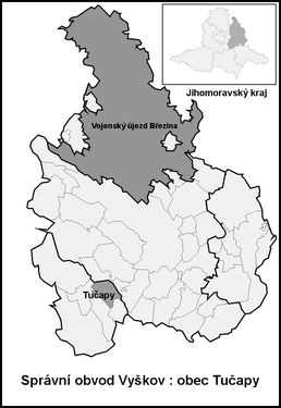
| Location of Tučapy in the Vyškov district | ||||

|
||||
Tučapy (German Tutschap , formerly Tuczap ) is a municipality in the Czech Republic . It is located eight kilometers southwest of Vyškov and belongs to the Okres Vyškov .
geography
Tučapy is located between the Drahaner Bergland and the Litenčické vrchy in the Vyškovská brázda ( Wischauer gate ). The village extends on the right bank of the Rakovec river at the confluence of the Habrůvka brook. The D 1 motorway passes to the east of the village ; the next exit 226 Vyškov-západ is five kilometers northeast. The Brno - Přerov railway line runs to the west ; the nearest railway station is Komořany u Vyškova .
Neighboring towns are Nemojany and Luleč in the north, Nosálovice, Nouzka and Rostěnice in the Northeast, Zvonovice and Hlubočany the east, Lysovice the southeast, Podbřežice and Komořany in the south, Kralovopolske Vážany and Vítovice in the southwest, Habrovany in the west and Olšany and Račice in the northwest.
history
The village was first mentioned in documents in 1358. Originally the village belonged to the Luleč domain . After the fall of Liltsch Castle, the Olomouc bishopric initially acquired its properties in 1462 and connected them to the episcopal estate of Wischau . A little later Tučapy became submissive to Habrovany . In the land register of 1465, 37 properties, a mill, two taverns, one with a distillery, and two fish ponds are identified for Tuczap . At that time the owner was Elisabeth von Liltsch on Habrowan. Subsequently, Tuczap was passed back and forth several times between the episcopal rule Wischau and the allodial estate Habrowan. In 1667 a town hall was built. Ultimately, the village remained with Habrowan until the middle of the 19th century. The school in Tučapy expired before 1848, since then classes have been held in Luleč.
After the abolition of patrimonial Tučapy / Tuczap formed from 1850 a municipality in the district administration Wischau . In 1869 a school was established next to Tučapy Town Hall. A new school building was built between 1884 and 1886. In 1885 the Svornost reading group was formed . The volunteer fire brigade was founded in 1900 . In 1909 a department of the Sokol was created , which initially formed a branch of the Sokol in Nemojany. In 1924, 753 people lived in the village. Tučapy was incorporated into Nemojany together with Luleč in 1976. The Tučapy municipality has existed again since 1989.
Community structure
No districts are shown for the municipality of Tučapy.
Attractions
- Bell tower and cross on the village green, erected in 1770
- Reservoir on the Habrůvka, west of the village
- Coat of arms of the Wischau rulership and the Olomouc diocese at the tavern, the right part of the building is the former town hall
Sons and daughters of the church
- Jaroslav Kratochvíl (1885–1945), Czech writer


