Radslavice u Vyškova
| Radslavice | ||||
|---|---|---|---|---|
|
||||
| Basic data | ||||
| State : |
|
|||
| Region : | Jihomoravský kraj | |||
| District : | Vyškov | |||
| Area : | 434 ha | |||
| Geographic location : | 49 ° 19 ' N , 17 ° 0' E | |||
| Height: | 330 m nm | |||
| Residents : | 410 (Jan. 1, 2019) | |||
| Postal code : | 683 21 | |||
| License plate : | B. | |||
| traffic | ||||
| Street: | Dědice - Radslavičky | |||
| structure | ||||
| Status: | local community | |||
| Districts: | 2 | |||
| administration | ||||
| Mayor : | Josef Školař (as of 2010) | |||
| Address: | Radslavice 91 683 21 Pustiměř |
|||
| Municipality number: | 593524 | |||
| Website : | www.radslavice.com | |||
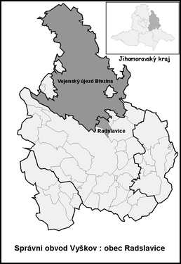
| Location of Radslavice in the Vyškov district | ||||

|
||||
Radslavice (German Groß Ratzlawitz ) is a municipality in the Czech Republic . It is located five kilometers north of Vyškov and belongs to the Okres Vyškov .
geography
The street village of Radslavice extends to the left of the Marchanka brook on the eastern slope of the Drahaner Bergland . To the north is the Březina military training area . The Věsperk ( Wiesberg , 457 m) rises to the northwest . Vyškov airfield is located three kilometers south-east on the R 46 .
Neighboring towns are Kotáry and Podivice in the north, Zelena Hora in the Northeast, Pustiměř the east, Pustiměřské Prusy and Křižanovice u Vyškova the southeast, Vyškov , Pazderna and Dědice in the south, sídliště Víta Nejedlého, Hamiltony and Lhota in the southwest, Pařezovice and Rychtářov the west and Véspěrk and Radslavičky in the northwest.
history
Archaeological finds show a Bronze Age settlement on the site of today's village, which dates back to the 7th century BC. Existed. In the 8th century, a Slavic settlement was founded from the castle on the hill of Hradisko. This Rundling was later expanded into a street village during the German colonization.
The first written mention of the village belonging to the Dědice lordship was in 1381. Since 1450, a free court can be found in the village. In the Moravian hoof register of 1677 43 properties are shown for Groß Ratzlawitz. Two of them were three-quarter hoppers, 25 half-huefers, five quarter-huefers and eleven gardeners. In 1764, the Klein Ratzlawitz clearing settlement was established northwest of Ratzlawitz. The old village of Ratzlawitz was subsequently referred to as Groß Ratzlawitz .
After the abolition of patrimonial Groß Ratzlawitz / Velké Raclavice formed from 1850 a community in the district administration Wischau . In 1860 a village school was inaugurated, before teaching took place in Dědice and then in Pustíměř. For the one-class village school, a new schoolhouse was inaugurated in 1868, which was attended by 170 students. At the end of the 19th century the village was also known as Hrubé Raclavice . In 1898 the school moved into a new building, which enabled a two-class school operation. Due to the increasing number of pupils, the three-class classes began at the beginning of the 1912/13 school year. The village has been called Raclavice since 1925 . During the German occupation in 1940, the decision was made to expand the Wischau firing range into a large military training area for the Wehrmacht . The 33 villages to be evacuated for the construction of the Wischau military training area , out of a total of 43 in all of Moravia, included in the first stage to be completed by October 31, 1941, also large and small Ratzlawitz. Groß Ratzlawitz had 784 inhabitants at that time and Klein Ratzlawitz had 255. After the end of the Second World War, the community was settled again from June 1945. 28 houses in the village were destroyed. In 1950 the municipalities of Radslavice and Radslavičky merged. The community consisted of 156 houses and had 536 inhabitants. In 1957 the kindergarten was established. Since the same year, teaching took place in the kindergarten building and in 1975 it was completely discontinued. As of January 1st, 2008 the community had 434 inhabitants. 35 houses are mainly used as holiday homes for Brno citizens.
Community structure
The municipality Radslavice consists of the districts Radslavice ( Groß Ratzlawitz ) and Radslavičky ( Klein Ratzlawitz ).
Attractions
- Bell tower on the village green
- Bell tower in Radslavičky, built in 2007
- Stone cross in front of the bell tower
- Museum of Aviation and Military Technology ( Muzeum letecké a vojenské techniky ) at Vyškov Airfield with decommissioned fighter jets.
- Slavic fortress Dolní Mejlice, east of the village above the valley of the Pustiměřský creek


