Podomí
| Podomí | ||||
|---|---|---|---|---|
|
||||
| Basic data | ||||
| State : |
|
|||
| Region : | Jihomoravský kraj | |||
| District : | Vyškov | |||
| Area : | 545 ha | |||
| Geographic location : | 49 ° 21 ' N , 16 ° 50' E | |||
| Height: | 552 m nm | |||
| Residents : | 430 (Jan. 1, 2019) | |||
| Postal code : | 683 07 | |||
| License plate : | B. | |||
| traffic | ||||
| Street: | Jedovnice - Vyškov | |||
| structure | ||||
| Status: | local community | |||
| Districts: | 1 | |||
| administration | ||||
| Mayor : | František Ambros (as of 2010) | |||
| Address: | Podomí 89 683 04 Drnovice |
|||
| Municipality number: | 550175 | |||
| Website : | www.podomi.cz | |||
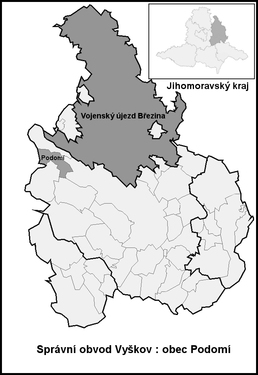
| Location of Podomí in the Vyškov district | ||||

|
||||
Podomí (German Poidom ) is a municipality in the Czech Republic . It is located 15 kilometers northwest of Vyškov and belongs to the Okres Vyškov . The municipality is part of the Drahanská vrchovina microregion .
geography
Podomí extends on the Drahan mountain plateau on the left bank of the Podomský creek . To the south is the Rakovecké údolí nature park. To the north rises the Kojál (600 m), in the south the Malina (571 m), southwest of the Lipový kopec (561 m) and in the northwest of the Slunný vrch ( Sonnhübel ). To the north is the medieval Schreynern desert , to the east the Ovčinek desert, to the southeast the Hamlíkov desert, to the south the Vilémov desert and to the southwest the Bystřec and Budkovany desert. To the east lies the valley of the Malá Haná. To the southwest is the Podomský rybník pond.
Neighboring towns are Krásensko and Kulířov in the north, Studnice in the northeast, Rychtářov and Ruprechtov in the southeast, Pastviny, Rakovec and Bukovinka in the south, Bukovina and Křtiny in the southwest, Jedovnice in the west and Senetářov in the northwest.
history
The village was probably founded as a forest hoof village in the second half of the 13th century during the colonization of the area by the lords of Čeblovice, who later called themselves von Hohlenstein . The first settlers were Germans. A member of the Hamelin bourgeois family Boda, who was one of 130 young people from Hamelin who emigrated to Moravia in 1284 and founded the village of Hamlíkov, was accepted as the locator . The name researcher Jürgen Udolph questioned this assumption in 1997 and refuted the derivation of the place name Hamlíkov from Hameln.
The to the rule was first mentioned Hohlenstein associated village Boda in 1349 in the country table in the registration of the place before 1321 sale of most of the government by Čeněk of Leipa at Wok / Vok, of the Moravian family of Hrut came from and independent tribe of men founded by Holstein . Podomí and Hamlíkov were among the 13 villages that were subject to the Hohlenstein lordship , along with the town of Holštejn and half of the town of Jedovnice . In 1371, Wok II of Holštejn was registered as the owner in the land register. His son Wok III. shared the property during his lifetime with his son Wok IV, who was based in Lipovec and who also used the title Wok from Lipovec . Wok IV died in 1420 in the battle of Vyšehrad . During the Hussite Wars , the area was devastated and the villages of Podomí and Hamlíkov became extinct. In 1437 Wok V. sold the rule to Hynek von Waldstein , who transferred it in 1448 to his son of the same name. In 1464 Hynek sold the western half of the desert village of Podomí to Smilek von Loděnice, he kept the eastern half as well as Kulířov and the desert Hamlíkov. As a result of this division, the western corridors were connected to the Senetářov and Kotvrdovice estates .
In 1550 the brothers Jan d. J. and Friedrich Dubčanský from Zdenín on Habrovany , who had their half of the village repopulated. In 1567 the Dubčanský von Zdenín sold the Vostrover share of the rule Hohlenstein including the repopulated eastern half of Podomí and the deserted Hamlíkov to Bernard Drnovský von Drnovice . In 1569 Vladike Vilém Jedovnický from Želetava bought the goods. He had the Great Poidomer Pond and other neglected fish ponds around Podomí and Hamlíkov renewed. Jedovnický's intensive efforts to prosper the newly acquired property also led to numerous feuds with neighboring lords. Finally Jedovnický sold the goods in 1576 to Hans Haugwitz von Biskupitz on Ratschitz , who joined them to his rule. The next owners were the lords of Peterswald, whose property was confiscated after the battle of the White Mountain . Thereafter, Ratschitz belonged to various Catholic noble families who re-Catholicized the rule. During this time there was a large influx of German settlers. In 1775 the village consisted of 15 houses. In 1797 the textile manufacturer Wilhelm Baron Mundy bought the goods. With the support of the Dutchman Jakob Leonard van den Bruch, he introduced sheep farming on the Poidom farm and the subjects wove high-quality woolen fabrics from the sheep's wool. In 1803 van den Bruch bought the farm and set up a factory for woven and spun goods. From then on, weaving was the main occupation of the residents of Poidom. in 1820 Poidom had grown to 55 houses. This trend continued and in 1832 415 people lived in the 65 houses of Poidom. Until the middle of the 19th century, the village always remained subservient to Ratschitz.
After the abolition of patrimonial Poidom / Pojdom formed from 1850 a district of the municipality Ruprechtov in the district administration Wischau . In the course of the introduction of compulsory schooling, a village school was built between 1868 and 1869. In 1869 the political municipality of Poidom was established. In 1880 a gendarmerie station was set up in Poidom for the villages of Poidom, Krásensko and Ruprechtov. The two-class village school was built in 1888. In the same year the volunteer fire brigade was founded . At the end of the 19th century the current place name Podomí was created . During the German occupation in 1940, the decision was made to expand the Wischau firing range into a large military training area for the Wehrmacht . The 33 villages to be evacuated for the construction of the Wischau military training area also included parts of Podomí in the last stage to be completed by April 1945. A broadcast tower for television and radio was built on the nearby Kojál hill between 1956 and 1958. 1964 Podomí was merged with Krásensko to form a municipality Krásensko-Podomí . This dissolved again in 1990.
Community structure
No districts are shown for the municipality of Podomí.
Attractions
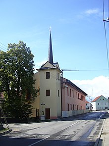
- Bell tower
- Cross, in front of the bell tower
- Kojál transmitter with a 339.5 m high transmitter mast on the hill of the same name north of the village
Sons and daughters of the church
- Ervín Černý (1913–2001), physician and historical geographer
Individual evidence
- ↑ Český statistický úřad - The population of the Czech municipalities as of January 1, 2019 (PDF; 7.4 MiB)
- ↑ Jürgen Udolph : Did the Hamelin emigrants move to Moravia? The Pied Piper legend from a naming point of view. In: Lower Saxony Yearbook for State History . Vol. 69, 1997, pp. 125-183.
- ↑ According to recent historical research, the descent of the Lords of Holštejn from the Lords of Sovinec is doubted or rejected. See David Papajík: Páni z Holštejna. Významný, ale zapomenutý panský rod (= Edice Šlechta zemí české koruny. 3). Bohumír Němec - Veduta, České Budějovice 2007, ISBN 978-80-86829-24-1 , as well as cs: Vok I. z Holštejna and cs: Páni z Holštejna .


