Burgwald
| Burgwald | ||
|---|---|---|
|
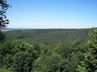
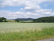
View from the Christenberg over the Gerhardsberg in the Burgwald to the Rothaargebirge (with the Bollerberg ) in the background |
||
| Highest peak | Knebelsrod ( 443.1 m above sea level ) | |
| location | Districts of Waldeck-Frankenberg and Marburg-Biedenkopf ; North and Central Hesse (Germany) | |
| part of | West Hessian mountain region | |
|
|
||
| Coordinates | 51 ° 0 ′ N , 8 ° 48 ′ E | |

The castle forest is a maximum of 443.1 m above sea level on the northeastern edge . NHN and otherwise moderately high low mountain ranges of the West Hessian mountainous region in North and Central Hesse ( Germany ).
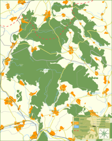
The “actual” castle forest is divided by federal road 3 into the northern castle forest , which is completely wooded except for clearings around settlements, and the significantly smaller and largely agricultural southern castle forest in the southeast. "Burgwald" is often used by the local population as a synonym for the northern castle forest .
geography
location
The Burgwald is located in the districts of Waldeck-Frankenberg and Marburg-Biedenkopf . To the northeast, he goes into the - - montaneren Kellerwald over, to the east close behind the Wohratal the the Upper Hessian Ridge counted Gilserberger heights on. To the south, behind the valley of the Ohm, follow the Amöneburg Basin and the Lahn Mountains , and beyond the Lahn, finally, the Marburger Ridge . In the west, the Wetschaft-Senke , in the northwest, the Eder delimits the Burgwald from the adjoining foothills of the Ostsauerland mountain range , the eastern roof of the Rothaargebirge . The highest point is Knebelsrod in the north .
The Burgwald is framed by these places: Frankenberg in the north, Haina , Gemünden and Wohratal in the east, Rauschenberg in the southeast, Cölbe in the south, Wetter in the southwest and Münchhausen and Battenberg in the west. Burgwald , Rosenthal and Bracht lie within the wooded low mountain range .
Natural structure
The Burgwald (main unit 345) is part of the West Hessian mountain and sink region (main unit group 34; also just called West Hessian mountainous region ), which extends from Gießen in the south to about Kassel and Korbach in the north. Of the counted for Burgwald lowering the valleys of the longitudinal Wetschaft , Wohra and Ohm and the northern slope just south of the Eder tals apart, the actual Burgwald divides especially in natural areas Northern (345.1) and Southern Burgwald on (345.2), wherein the Northern Burgwald makes up the predominant part of the forest area, while the Southern Burgwald represents only the (fragmentary) part of the forest that has been cut off from the core forest by the traffic route from Marburg to Kassel ( Bundesstrasse 3 ) since time immemorial. Since around half of the former forest south of the B 3 was cleared for agricultural use - in particular the entire part north of the town of Rauschenberg as well as the south-west slope near Sindersfeld - there is still around 1500 hectares of contiguous forest area that belongs to the Rauschenberg state forest .
The natural spatial main unit Burgwald is structured as follows:
-
345 Burgwald (494.28 km²)
- 345.0 Wetschaft Depression (121.61 km², west)
- 345.1 Northern Burgwald (204.79 km²)
- 345.2 Southern Burgwald (49.64 km²)
- 345.3 Wohratal (38.26 km², south east)
- 345.4 Buntstruth (22.98 km², northeast)
- 345.5 Frankenberger Oberland
- 345.50 Bottendorfer Flur (26.40 km², west north)
- 345.51 Geismarer Platte (21.63 km² without Hauberner Hecke, east north)
- 345.510 Hauberner Hecke (8.97 km², southeast of the plate)
While the almost unwooded Wetschaft depression differs significantly from the actual wooded red sandstone ridges of the Burgwald, these continue beyond the larger river valleys to the southwest and east:
- beyond the Lahn to the southeast in the Marburger ridge (347.00)
- beyond the Ohm to the south in the Lahn Mountains (347.01)
- beyond the Wohra to the east in the Gilserberger heights (346.0, without the Hemberg in the north, where there are already slate rocks)
Rivers
A section of the Rhine-Weser watershed between the Rothaargebirge and the Kellerwald runs over the Burgwald, but most of it drains south to the Lahn and thus to the Rhine . In contrast , the Eder , which runs close to the border in the north, is only fed by a few noteworthy streams from the castle forest, as the center of gravity of the low mountain range is clearly shifted to the north (east).
In the following, the most important rivers of the Burgwald are listed in clockwise order, starting on the eastern south side of the Rhine-Weser watershed.
| Surname | Target flow |
Length ( km ) |
EZG km² |
Discharge ( MQ ; l / s ) |
Remarks | GKZ |
|---|---|---|---|---|---|---|
| Bach of Römershausen | Pig → Wohra | 5.1 | 10.1 | 75 | north-eastern border river | 258282-4 |
| Holzbach | Pig → Wohra | 9.3 | 18.0 | 131 | 258282-8 | |
| Meeting | Wohra | 13.1 | 48.9 | 268 | 25828-4 | |
| Wadebach | Wohra | 4.0 | 12.7 | 84 | Interface to the southern castle forest | 25828-72 |
| Rauschenberger Bach | Wohra | 2.7 | 6.9 | 48 | Southern castle forest | 25828-92 |
| Devil's Trench | ohm | 5.0 | Southern castle forest | 2582-X | ||
| Schwarzenbornbach | Red water | 5.6 | 8.8 | 50 | 25896-6 | |
| Red water | ohm | 18.6 | 51.0 | 221 | 2589-6 | |
| Bach from the Long Reason | Red water | 6.9 | 9.0 | 35 | 25896-8 | |
| Rosphe | Wetschaft (lower course) | 8.2 | 18.6 | 76 | 25818-8 | |
| Mellnau | Wetschaft (lower course) | 7.3 | 8.8 | 62 | 25818-72 | |
| Bach from the Christenberg | Wetschaft (lower course) | 6.0 | 6.8 | 35 | 25818-52 | |
| Silberbornbach | Wetschaft (lower course) | 2.7 | 4.8 | 28 | 25818-32 | |
| Wetschaft overflow (*) | Lahn | 13 | 36.1 | 226 | to Ernsthausen | 258-18 |
| Senkelbach | Wetschaft | 5.6 | 11.6 | 83 | 25818-2 | |
| Bach from Lichtenberg | Wollmar → Wetschaft | 7.5 | 7.5 | 70 | crosses a northwest branch along the B 236 | 258184-4 |
| Nemphe | Eder | 14.2 | 38.4 | 294 | 428-198 | |
| Cold water | Nemphe | 8.8 | 15.2 | 112 | 428198-4 | |
| Lengelbach (**) | Eder | 3.4 | 6.7 | 59 | to Dainrode ; Grenzbach | 428-32 |
(*) The Wetschaft is in the lower reaches up to its confluence with the Lahn border river and has a total length of 29 km, has a catchment area of 196.2 km² and has a discharge of 1702 l / s. Meanwhile, half of their water (810 l / s) comes with the Treisbach, which flows late, from the Rothaargebirge or the Sackpipe Vorhöhen . Another 278 l / s come from the Wollmar - also from the foreshore.
Both of the rivers mentioned contribute more water to the river wedding with the Wetschaft than the latter itself, whereby the Wollmar is partly also fed from the castle forest (see table). If you add the outflows of the tributaries of the Wetschaft lower reaches plus the listed Wollmar tributary, you get about 500 l / s. So the Wetschaft remains by far the most water flowing out of the castle forest.
(**) The Lengelbach is 11.4 km long, has a catchment area of 25.8 km² and carries 210 l / s. However, shortly after its source it leaves the "actual" castle forest.
geology
The castle forest consists of red sandstone . In the Triassic geological age about 220 million years ago, sediments from the Rhenish Slate Mountains were deposited in the Germanic Basin to the south of it . A stratified table was created that broke into several pieces when the area was raised again in the Tertiary . These pieces then became the mountains and hills of today's castle forest.
In its western to north-eastern rim depressions Wetschaft-Senke , Frankenberger Oberland and Buntstruth , the Burgwald is surrounded by a Zechstein belt that separates the Buntsandstein from the slate of the Ostsauerland mountain range and the Kellerwald ; the border valleys of Wetschaft , Ohm and Wohra in the southern half contain a lot of loess .
climate
It is much colder in the Burgwald than in the surrounding areas. It lies in the slipstream of the Rothaargebirge , which, with heights of up to 800 meters, absorbs part of the mild west winds . Especially in the central hollow, the Franzosenwiesen, a cold air lake is created on many nights . Because the peat mosses present there evaporate large amounts of liquid (up to 20 times as much as a water surface of the same size), which causes a certain degree of cooling. The cooling air that sinks towards evening flows through the supply valleys into the central basin. In combination with the air that has been cooled down on site (which is also reflected in the high frequency of fog), pools of cold air are created that remain overnight. These phenomena are also known from the Bavarian Forest , for example .
Late or early frosts often occur in the surrounding villages. Long-term measurements by the University of Marburg on the Franzosenwiesen showed that there were night frosts every month of the year. In summer , the temperature difference during the day can be up to 30 degrees Celsius .
The average annual precipitation is 700 mm and thus well below the total precipitation of the adjoining low mountain range, as the castle forest is in the rain shadow of the Rothaargebirge . On the Franzosenwiesen only 535 mm are reached.
Overall, the climate of the castle forest with its relatively low rainfall and greater temperature contrasts is significantly more continental than that of the surrounding regions, microclimatically but also very Atlantic-tinged due to the high humidity near the ground. This combination enables plant and animal species from very differently toned climates to survive.
Name meaning
The meaning and origin of the name Burgwald is unknown. According to one theory, the name is derived from the numerous prehistoric and early historical castles such as the Christenberg . Possibly the original meaning was simply "mountain forest".
history
The earliest traces of human activity in the Burgwald are Paleolithic tools such as stone blades and scrapers for meat processing that were found near Willershausen . In Bracht one was Bandkeramik settlement from the period of 4500 v. Discovered. At that time there were large stocks of sparse sessile oak forests in the Burgwald , interspersed with silver birch , common hazel , willow , aspen and pine . Since approx. 1800 BC The oaks were pushed back due to climatic reasons and the beech began to dominate the forest. Some barrows from this period have been preserved.
During the Iron Age , the Wetschaft valley west of the Burgwald was built between 750 and 300 BC. Settled by the Celts . The Christenberg (Kesterburg) was a Celtic princely seat and a refuge at the same time. This Celtic castle was destroyed by fire. Around the second half of the 1st century. v. BC probably scattered parts of Germanic tribes penetrated into the castle forest region, which then joined with other groups to form the Chatten tribe .
Since the year 469 AD the Chatten belonged to the empire of the Franks and in the 7th century a new Carolingian fortress against the Saxons was built on the Christenberg . After the end of the Saxon Wars , the Christenberg was mainly important as a church center.
Numerous medieval attempts at settlement in the inner castle forest failed before BC. a. the unfavorable climate and poor soils. The forest was initially a royal forest and came into the possession of the Landgraves of Hesse in the Middle Ages . But it was also used intensively by the farmers in the surrounding villages. In particular, cattle , sheep and pigs were driven into the forest for fattening . So-called hut forests emerged with large, widely spaced trees, especially oaks and beeches. In addition, massive wood was also felled, including for the Frankenberg silver and copper mines. As a result, around 1800 there were only very few trees left in the castle forest.
Since 1464, the Landgraves of Hesse had sole hunting rights in the castle forest. The Wolkersdorf hunting lodge was built between 1481 and 1484 and the Bracht hunting lodge in 1744. Both were connected by the so-called Herrenweg through the middle of the castle forest. Several rest areas were also laid out along the way, including the so-called men's benches near Rosenthal. During these years there were reports of violent conflicts over hunting rights. In 1533 Landgrave Philipp had a large number of Rosenthal citizens arrested for poaching . However, they managed to break out of prison . On June 23, 1623, the forester Hans Glas was shot by poachers in the Burgwald, on June 28, 1676, chief forester Hans Roß died in a firefight with poachers. The landgraves mainly hunted wild boar , but in the 18th century the red deer had increased so much due to feeding that Landgrave Wilhelm VIII hunted over 450 in 6 hunts in September 1772. At the time of the Kingdom of Westphalia , King Jérôme Bonaparte also used the Wolkersdorf hunting lodge.
In the 19th century, the castle forest was intensively reforested with spruce , pine and silver fir . Since then, conifers have dominated the previously pure deciduous forest area. The spruce trees in particular, with their shallow roots, led to the regeneration of the severely degraded soil and also grew very quickly.
The proportion of deciduous forest in the castle forest is currently being increased again.
French meadows
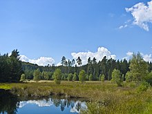
The Franzosenwiesen lie in a depression in the middle of the castle forest. They consist of an ecologically valuable complex of moors , wet meadows , still waters and alluvial forests . The Red Water , a northern tributary of the Ohm , flows through them in a west-east direction . The area is under nature protection and is part of the transnational protected area system Natura 2000 .
Up until the 18th century the area known as the “Brücher” was a bog . In 1725, Landgrave Karl gave it to Huguenot settlers from Schwabendorf for use. In the western part of the so-called Franzosenwiesen, the moor has been preserved. The eastern part was drained and used as a hay meadow . The Huguenots were obliged to fill up all the barns standing there with the harvested hay for feeding game; they were only allowed to take the remaining hay and moss with them to Schwabendorf.
As a result of the abolition of feudal privileges in the Landgraviate of Hessen-Kassel , the Franzosenwiesen became allodial property of the Schwabendorf farmers from 1848 onwards .
From 1898, the farmers began to sell their land to the Prussian forest treasury . These were partially afforested with conifers.
In 1985 45 of the 65 properties belonged to the forest administration and the remaining 20 to private individuals. Two years later, in 1987, the French meadows were placed under nature protection.
It is planned to remove the conifers and to close the drainage ditches. As a result, the wet meadows should develop in the direction of transitional or vibrating lawn moor. The remaining private areas are to be leased or bought.
natural reserve
The special need for protection of the castle forest was shown very early on by the evidence of rare animal and plant species. Gerd Hoyer found the rough owl in 1966 , and soon afterwards other rare bird species were discovered. Since the end of the 1950s, the Burgwald was also examined botanically and bryologically and, above all, Dr. Kurt Kellner was able to prove many peculiarities, for example Sphagnum imbricatum .
At the beginning of the 1970s, the route of the Federal Motorway 4 was planned through the middle of the Burgwald and large-scale water extraction was discussed. As a result of this acute danger, resistance began to be organized and in 1977 the “Rettet den Burgwald e. V. “ founded. This worked in cooperation with other nature conservation associations such as NABU and HGON for the preservation of the castle forest.
In the further course the protection of particularly valuable habitats was given priority, but their investigation was also accelerated. In the course of time, ten nature reserves were designated, which were included as FFH areas in the Natura 2000 network of protected areas . The core of the castle forest was included in this network of protected areas as a bird sanctuary.
Currently, the efforts of the nature conservation associations apply on the one hand to the A4, which has re-emerged in the public discussion, on the other hand to their own renaturation projects and active communication with land users, especially the forest administration. By switching to natural silviculture and the great interest of those responsible on site in the issues of nature conservation, good cooperation is possible and is actively carried out.
One problem, however, is that some farmers who own land in the Franzosenwiesen NSG still do not want to sell them to the State of Hesse. There are still spruce forests on them, which look like a foreign body in the raised bog. Therefore the rewetting of the eastern French meadows cannot be tackled either.
Tree veterans
In the castle forest there are numerous trees several hundred years old. Mostly these are oaks.
At the forester's house on the Hirschberg, for example, there are 13 so-called Hute oaks , which, planted at large intervals, were once used for fattening pigs, of which the most striking example measures 8 m in trunk circumference.
Elsewhere, old oaks can be found in many places in the interior of the forest.
In the clearing of Rosenthal, finally, stands the court oak on Galgenberg (over 7 m trunk circumference) at a prominent height , the name of which already suggests that courts not only met but were also carried out.
By far the most striking and oldest tree (at least 700 years, 9 m trunk circumference) is a summer linden tree and stands in the middle of the village of Himmelsberg in the extreme southern castle forest .
mountains
This list contains a selection of mountains and hilltops in the Burgwald - sorted by height in meters (m) above sea level, unless otherwise specified, usually according to the BfN:
- Knebelsrod ( 443.1 m ), north, southeast of Friedrichshausen , Waldeck-Frankenberg district
- Todtenhöhe ( 424.1 m ), north, northeast of Willersdorf , Waldeck-Frankenberg district
- Heukopf ( 420.8 m ), north, northeast of Willersdorf , Waldeck-Frankenberg district
- Wasserberg ( 412.2 m ), in the west, south-east of Rosenthal -Roda, Waldeck-Frankenberg district
- Tauschenberg ( 406.7 m ), in the south, northwest of Bracht , district of Marburg-Biedenkopf
- Geiersköpf ( 405.2 m ), in the southwest, north-northeast of Mellnau , district of Marburg-Biedenkopf
- Schönelsberger Kopf ( 401 m ), in the west, northeast of Rosenthal -Roda, Waldeck-Frankenberg district
- Gerhardsberg ( 398.7 m ), western edge, east of Münchhausen , Marburg-Biedenkopf district
- Pfaffenkopf ( 391.6 m ), northwest, southeast of Burgwald (Industriehof), Waldeck-Frankenberg district
- Hohehardt (approx. 391 m ), in the northwest, southeast of Rosenthal -Roda, Marburg-Biedenkopf district
- Christenberg ( 387.4 m ), western edge, east of Münchhausen , Marburg-Biedenkopf district
- Forehead light ( 387.5 m ), southwest, east of Oberrosphe , Marburg-Biedenkopf district
- Finsterkopf ( 386.2 m ), in the north-west, north-east of Burgwald (Industriehof), Waldeck-Frankenberg district
- Sattelkopf ( 383.7 m ), southwest, east of Mellnau , Marburg-Biedenkopf district
- Himmelsberg (approx. 381 m ), extreme (north) west, Waldeck-Frankenberg district
- Alter Rauschenberg ( 376 m ), south, south-south-west of Rauschenberg- Schwabendorf, Marburg-Biedenkopf district
- Großer Hirschberg ( 361.3 m ), south, south of Bracht , Marburg-Biedenkopf district
- Galgenberg ( 358 m ), east, north of Wohra , Waldeck-Frankenberg district
- Hauptkopf ( 357.1 m ), in the southeastern Mönchwald , near Rauschenberg -Albshausen, Marburg-Biedenkopf district
- On the Siegel (approx. 344 m ), south, district of Marburg-Biedenkopf
- Söhler (approx. 338 m ), southeast, southwest of Wohratal- Langendorf, district of Marburg-Biedenkopf
- Kainsberg ( 324.3 m ), west of the Burgwald, near Münchhausen -Wollmar, Marburg-Biedenkopf district
- Eibenhardt ( 301.5 m ), southernmost mountain of the Burgwald (at the interface to Lahnbergen ), northeast of Cölbe , Marburg-Biedenkopf district
literature
- Heinrich Boucsein: The castle forest . Elwert, Marburg 1955.
- Hessian Society for Ornithology and Nature Conservation (Ed.): Nature Conservation and Development Concept Burgwald . Wohratal 1996 (no ISBN, can be bought from HGON for 12.80 euros).
- Karl Junk, Heiner Salz: stone markings in the castle forest. History and stories of 52 stone paintings in the castle forest . Burgwald-Verlag, Cölbe-Schönstadt 2003, ISBN 3-936291-19-5 .
- Gerhard Wagner, Eva Merz, Ursula Mothes-Wagner: The Burgwald . Ed .: HGON. Wohratal 1995 (brochure without ISBN).
- Günther Wilmink, Annette Schmidt, Anne Archinal, Lothar Feisel: Fascination Burgwald . Self-published, Marburg 2011, ISBN 978-3-00-035842-5 .
General sources
-
Landscape profiles of the Federal Agency for Nature Conservation ( notes ):
- 34501 Burgwald
- 34502 edge sinks (marked with " Wetschaft Buntstruth Frankenberger Oberland Bottendorfer Flur ")
Web links
- Burgwald (nature conservation project of the Hessian Society for Ornithology and Nature Conservation Marburg-Biedenkopf), on hgon-mr.de
- The Burgwald (action group Rettet den Burgwald eV), on ag-burgwald.de
- The Burgwald natural area (brief description), on oberrosphe.de
- Map / aerial photo of the castle forest with natural boundaries , rivers and all important elevations / placemarks ( Google Earth required)
References and comments
- ↑ a b Map services of the Federal Agency for Nature Conservation ( information )
- ↑ Martin Bürgener: Geographical Land Survey: The natural spatial units on sheet 111 Arolsen. Federal Institute for Regional Studies, Bad Godesberg 1963. → Online map (PDF; 4.1 MB)
- ^ Gerhard Sandner: Geographical land survey: The natural space units on sheet 125 Marburg. Federal Institute for Regional Studies, Bad Godesberg 1960. → Online map (PDF; 4.9 MB)
- ↑ Map and legend of the natural areas of Hesse (online copy of Die Naturraum Hessens , Otto Klausing 1988) in the Hessen Environmental Atlas of the Hessian State Office for Environment and Geology
- ↑ Water map service of the Hessian Ministry for the Environment, Climate Protection, Agriculture and Consumer Protection ( information )
- ↑ For a better overview and sorting downstream, a hyphen has been inserted for each river in the water code number (GKZ) after the numbers “258” and “428”, which stand for the Lahn and the Eder .
- ^ "Geological overview map of Hesse". Historical atlas of Hessen. In: Landesgeschichtliches Informationssystem Hessen (LAGIS).
- ↑ See Gerhard Wagner (inter alia), p. 4.
- ↑ See Gerhard Wagner (inter alia), p. 12 ff.
- ↑ Rast an den Herrenbänken ( HNA ), from July 13, 2011, on hna.de.
- ^ Die Franzosenwiesen im Burgwald - a historical calendar (Working Group for Huguenot and Waldensian History Schwabendorf eV), on schwabendorf.de
- ↑ Franzosenwiesen and Rotes Wasser ( Memento from July 9, 2012 in the web archive archive.today ) in standard data sheet excerpt for FFH area proposal (Hessian Ministry for the Environment, Energy, Agriculture and Consumer Protection), from hmulv.hessen.de
