
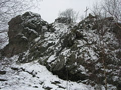
Bruchhauser stones

.jpg)
Goldstein , Bornstein , Feldstein and Ravenstein (from left to right);
with L 743 (front; on row of trees)

- Bornstein on the left , Goldstein behind
- Ravenstein on the right , Feldstein behind
( Hochheideturm on the southeastern horizon)


The Bruchhauser stones are a rock formation with four main rocks at 728 m above sea level. NHN high Istenberg in the Rothaar Mountains . They are located near Bruchhausen in the North Rhine-Westphalian Hochsauerlandkreis .
The rocky landscape is designated as a ground monument , a nature reserve , fauna-flora-habitat , bird sanctuary and national natural monument . The rocks have also been recognized as a national geotope and, as an element of geological heritage that is worth protecting, they are part of the National GeoPark GrenzWelten .
The highest rock, the Bornstein , is 92 m high. The Bruchhauser Steine Wallburg used to be between the four main rocks .
geography
location
The Bruchhauser stones rise up in the northern part of the Rothaargebirge on the northwest slope of the 728 m high Istenberges , the east of the origin of the Ruhr -Zuflusses Gierskoppbach located Bruchhausen lies a village district of Olsberg . The rocks are on average about 600 m from the mountain top.
Natural allocation
The Bruchhauser stones belong as part of the Istenberg in the natural spatial main unit group Süderbergland (No. 33), in the main unit Rothaargebirge (with Hochsauerland ) (333) and in the subunit Hochsauerländer Schluchtgebirge (333.8) to the natural area Schellhorn and Treiswald (333.82), in which they form a 4th to 7th order singularity . The landscape descends in western directions into the natural area Bödefelder Mulde (with Assinghauser Grund) (333.80).
The four stones
The four main rocks of the Bruchhauser Stones are called - with rock height in meters (m), height in meters (m) above sea level (NHN) and area in square meters (m²):
Bornstein
The Bornstein (in the north-northeast) is the highest of the four rocks with a rock height of about 92 m. Its summit is around 700 m above sea level. The base of the rock is about 5,000 m². Its name is probably derived from a spring that used to exist on the summit (Born = spring). The rock is the preferred breeding ground for the peregrine falcon.

Bornstein in summer

Eastern corner of the Bornstein


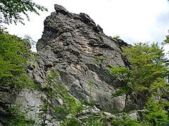
Field stone
The field stone (in the south-southwest) has a rock height of about 45 m. Its summit is around 756 m above sea level. The rock has an area of around 2,000 m². Its name is probably derived from field (field = wide level). The field stone is the only one of the four stones that can be climbed - on the Thomas-Neiss-Steige . Its summit, on which a 9 m high wooden cross stands, towers 28 m above the Istenberg summit. A trigonometric point is located southeast below the rock summit at a height of 727.2 m .

Feldstein , the only accessible rock of the Bruchhauser stones
Field stone in winter

Thomas-Neiss-Steige: steep ascent to the field stone

Summit of Feldstein looking north
_von_Osten.jpg)


.jpg)
Goldstein
The Goldstein (in the east) is about 60 m high. Its summit is around 712 m above sea level. The rock has an area of around 2,000 m². Its name probably comes from the golden shimmering quartz inclusions in the rock. On the eastern flank of the Goldstein is the stone formation Great Elector , whose profile (with a lot of imagination) resembles the head of the Great Elector .
Goldstein

Two Junguhus am Goldstein (2005)

Great Elector , rock formations on the Goldstein
.JPG)

.JPG)
Ravenstein
The Ravenstein (in the west) is about 72 m high. Its summit is around 701 m above sea level. It has a floor area of around 2,200 m². Its name probably comes from Rabenstein, the stone of the corvids.

Ravenstein

geology
The Bruchhauser stones are made of porphyry and the basement is made of soft clay slate , which was formed around 370 million years ago in the Devonian period from deposits of a prehistoric sea. During later volcanism 290 million years ago, lava penetrated into crevices of this clay slate to the sea floor. When the lava cooled down, different lava rocks such as diabase and quartz keratophyres were formed, depending on the chemical composition of the lava . During the Variscan Folding , around 100 million years later at the end of the Carboniferous Age, the former sea floor was raised to form high mountains . In the following millions of years this mountain range was eroded away again. During erosion, the harder lava rocks resisted weathering better than the clay slate surrounding them. So the rocks of the Bruchhauser stones remained, while the clay slate surrounding them disappeared.


Prehistoric finds
The Bruchhauser Steine Wallburg used to be located between the Bruchhauser Stones . Their fortification includes the four main rocks. These rocks were connected with ramparts, whereby today only parts of the ramparts are visible. During excavations , post holes from earlier wooden palisades were found in the walls.
The exact historical significance and use of the Bruchhauser stones is still unclear today. It is assumed to be used as a prehistoric refuge . It is also assumed to be used for cultic, economic, representative, administrative and political functions. It is unclear, for example, whether the Bruchhauser stones were permanently settled or rather served as a refuge. The archaeoastronomer Burkard Steinücken suspects that the Bruchhauser stones were used for calendar bearings of the moon and solstice dates.
On the basis of fragments found on and in the vicinity of the rocks, a meeting place for a rock sanctuary is assumed. A bronze, Iron Age hollow hump bracelet that was found in 2013 points in the same direction. Speculations that this is the famous Tamfana sanctuary mentioned by Tacitus cannot be proven based on the current finds.
The finds from the 8 hectare to at least 11 hectare complex date to the early and middle Iron Age (6th / 5th to 3rd century BC); It was visited again in the early and high Middle Ages. The oldest find was a small ax from the Neolithic Age .
In the years 1938, 1949 and 1996 to 1998 excavations were carried out in the area of the earth walls on the Bruchhauser stones.
Flora and fauna
The rocks are of particular floristic importance for the whole of northwest Germany due to the Alpine rock cress ( Arabis alpina ) on the Bornstein and Ravenstein rocks , which are considered a relic from the Ice Age and are found here far beyond the main distribution. The next occurrences are only found in the Black Forest . Other special features are the hawkweed ( Hieracium onosmoides ) and the pale hawkweed ( Hieracium schmidtii ) on the field stone . The only occurrence of the folded lady's mantle ( Alchemilla plicata ) in North Rhine-Westphalia is in the meadows below the rocks . The moss and lichen flora also show some great rarities. Here, are particularly Blytts Craw Fork Teeth Moss ( Kiaeria blytti ) Spruces yellow bag Moss ( marsupella sprucei ) Douinis Moss ( Douinia ovata ) and Overlooked Krätzflechte ( Lepraria neglecta ) to name. Other very rare lichens such as the two bowl lichen Parmelia amphalodes and Parmelia incurva , as well as Schaeria tenebrosa and Lecidea caesioatra don't even have a German name. These mosses and lichens, which are very rare in Germany, are found primarily in the Alps and the Arctic.
The eagle owl ( Bubo bubo ) was found here until 1876 . The last brood in 1876, with three Junguhus, was robbed and taken to the zoo in Münster. Massive persecution resulted in the last brood for a long time in 1903 in the Hochsauerland in the city of Brilon. It was not until 1976 that the re-colonization of the Hochsauerland in the urban area of Marsberg took place after bred eagle owls were released. In 1995 the rocks were also repopulated. Broods have been detected so far at Ravenstein , Bornstein and Goldstein .
Peregrine falcons ( Falco peregrinus ) have been shown to breed for the first time around 1900. But already Annette von Droste-Hülshoff , the most famous writer in Westphalia, wrote in 1840: "Hawks, falcons and owls settle in the jagged rocks and increase the impression of the wildly picturesque picture with their whistling and silent circling of the spikes." From 1967 to 1972 they were Bruchhauser Steine is the only place still occupied in North Rhine-Westphalia. Then the rocks, like all of Germany north of the Neckar, were uninhabited. After the peregrine falcon had recovered due to massive protective measures, it was repopulated in 1989. The peregrine falcon has so far brooded on Bornstein and Ravenstein .
In the Bruchhauser Steine conservation area there are also the species of rough-owl , black woodpecker and gray woodpecker . Earlier breeding birds are the common raven , jackdaw and kestrel .
Protected areas
The Bruchhauser Stones are officially designated as a ground monument and also as a nature reserve , fauna-flora-habitat and bird sanctuary - each with the name Bruchhauser Steine . The nature reserve Olsberg borders on these protected areas .
On March 24, 2017, the Bruchhauser stones were designated as the second national natural monument in Germany.
National geotope
On May 12, 2006, the Bruchhauser stones were awarded a National Geotope . On this occasion, the title National Geotope and the logo planeterde were awarded by the Federal Ministry of Education and Research . In addition, the geotopes have been immortalized in an accompanying book. The award was the result of a competition organized by the Hanover Academy of Geosciences (AGH). 77 significant geotopes in Germany and in the Sauerland, in addition to the Bruchhauser Stones, only the Rock Sea Hemer were awarded as a national geotope .
Sponsorship
.jpg)
The area at the Bruchhauser Steinen was acquired by the State of North Rhine-Westphalia from the Fürstenberg family and looked after by their own foundation , the Bruchhauser Stones Foundation , established in 1992 . This publishes the rocks - viewed from a touristic point of view - in the context of flyers as a soil and cultural monument and on its website as a natural monument , although officially only soil monument applies.
Info center, admission and visitor numbers
The Bruchhauser Stones Information and Service Center (hereinafter referred to as the Info Center ) of the Bruchhauser Stones Foundation is located a little to the west below the Bruchhauser Stones at an altitude of almost 525 m . At the official entrance to the rocks located there, visitors have to pay an entrance fee and a parking fee for their vehicle. In 2015, the annual number of paying visitors was given as around 15,000; and around 1,000 visitors took part in a guided tour by a nature guide from the foundation.

Hiking and viewing opportunities
The Rothaarsteig leads past a few meters below the information center . For example starting at this house you can walk up to the rocks. You can explore the area of the rocks via various paths with information signs , such as the forest and forest path , archaeological path , geological path and Gaugreben'scher Jägersteig . Since all paths connect to one another, they can also be walked as a circular route.
The rocks have been closed all year round as a climbing area since 1989 in order to protect the nature there. However, the Feldstein can be climbed on the Thomas-Neiss-Steige , which is partly secured with handrails and chains . From its summit there is a view down to Bruchhausen, the local Rothaargebirge, the Fredeburger Land in the southwest, the Arnsberg Forest in the northwest and the Teutoburg Forest in the north.

Paragliding
About 300 and 630 m south-southeast of the Feldstein are two launch sites for paragliders : the southwest launch site with a kite ramp and the west launch site . There leads to the Info Center starting west past the rocks one at the coming of Bruchhausen access road (see section transport links followed) infrastructure ; it ends at the hikers' car park on the western highlands of the Istenberg.
Transport links
The district road 47, which runs from Assinghausen to and through Bruchhausen , leads to the west past the Bruchhauser stones, which leads to state road 743 ( Olsberg - Elleringhausen - Brilon-Wald / B 251 ) laid out north of the rocks . On the northern edge of Bruchhausen, a narrow spur road branches off from the K 47, which runs eastwards to the chargeable hikers' parking lot at the information center and thus towards the rocks. Alternatively, you can continue to follow the street from this parking lot (against payment) and drive to the aforementioned parking lot on Istenberg.
See also
- List of nature reserves in the Hochsauerlandkreis
- List of FFH areas in North Rhine-Westphalia
- Bruchhauser Steine (bird sanctuary)
literature
- Torsten Capelle : Wall castles in Westphalia-Lippe. Published by the Antiquities Commission for Westphalia, Münster 2010, ISSN 0939-4745 , p. 20 f. No. FBW3 (Early Castles in Westphalia special volume 1) .
- Wolfgang Dehn: "Holy" rocks and rock sanctuaries , in: AFD supplement 16, contributions to prehistory and early history I, Berlin 1981.
- Gisela Graichen : Das Kultplatzbuch , Hoffmann and Campe Verlag, 4th edition, Hamburg 1990, ISBN 3-455-08282-3 .
- Michael Grundmann, Christoph Lünterbusch: Botanical Guide to the Bruchhauser Stones - A guide to the flora and vegetation of the foundation area in the Bruchhauser Stones nature reserve of the same name, Bruchhauser Stones Foundation, Olsberg-Bruchhausen 1999.
- Martin Lindner: Peregrine falcon and eagle owl on the Bruchhauser Steinen - A historical consideration , Bruchhauser Stones Foundation, Olsberg-Bruchhausen 2009.
- Bruchhauser Stones Foundation (ed.): Bruchhauser Stones Foundation - A Guide to the Area , Bruchhauser Stones Foundation, Olsberg-Bruchhausen 2009.
- Wilhelm Winkelmann : The Bruchhauser Stones near Olsberg / Hochsauerlandkreis (= early castles in Westphalia , issue 3), Münster 1983.
- Martin Lindner: The Bruchhauser Stones - even giants are threatened (PDF; 1.85 MB), Irrgeister 2006/23. Pp. 26-28.
Web links
- "Bruchhauser Steine" nature reserve in the specialist information system of the State Office for Nature, Environment and Consumer Protection in North Rhine-Westphalia
- Bruchhauser Stones Foundation (homepage of the foundation)
- 360-degree panorama Bruchhauser Steine , on the field stone (labeling of visual targets can be activated), on panorama-photo.net
- Bruchhauser stones , natural treasures of South Westphalia (German, English, French)
Individual evidence
- ↑ a b Topographical Information Management, Cologne District Government, Department GEObasis NRW ( Notes )
- ↑ a b c d Map services of the Federal Agency for Nature Conservation ( information )
- ↑ a b Ministry of the Interior and Municipalities of the State of North Rhine-Westphalia, Section 56: Ordinance on the National Natural Monument Bruchhauser Stones (NNM-VO Bruchhauser Stones) , in: Law and Ordinance Gazette (GV.NRW.), 2017 edition, No. 14, pp. 371 to 386. April 5, 2017, accessed April 5, 2017 .
- ↑ a b Most important geotopes - Bruchhauser stones near Olsberg , Geological Service NRW, on gd.nrw.de (PDF; 6.4 MB)
-
↑ a b c d e f g h i j k l m Boden- und Kulturdenkmal ( Memento of the original from June 13, 2016 in the Internet Archive ) Info: The archive link was inserted automatically and has not yet been checked. Please check the original and archive link according to the instructions and then remove this notice. , on stiftung-bruchhauser-steine.de see u. a. also the following flyers available at the Information and Service Center Bruchhauser Steine (e.g. 2013 available there; publication date not mentioned): - The Bruchhauser Stones - a brief information , section The Bruchhauser Stones as a soil and cultural monument , publisher: Stiftung Bruchhauser Stones, 4-page DIN A5 flyer, p. 2 - The Bruchhauser Stones - older than the dinosaurs , section soil and cultural monument , publisher: Foundation of the Baron von Fürstenberg-Gaugreben and the State of North Rhine-Westphalia, Olsberg, 2 -page flyer, 20.5 × 20.5 cm
- ↑ Martin Bürgener: Geographical Land Survey: The natural spatial units on sheet 111 Arolsen. Federal Institute for Regional Studies, Bad Godesberg 1963. → Online map (PDF; 4.1 MB)
- ↑ Individual display ( memento of the original from March 6, 2016 in the Internet Archive ) Info: The archive link was inserted automatically and has not yet been checked. Please check the original and archive link according to the instructions and then remove this notice. (four rocks), on stiftung-bruchhauser-steine.de
- ↑ History of origin ( Memento of the original from September 6, 2017 in the Internet Archive ) Info: The archive link was inserted automatically and has not yet been checked. Please check the original and archive link according to the instructions and then remove this notice. , on stiftung-bruchhauser-steine.de
- ↑ Wilfried Stichmann: The Bruchhauser stones - The return of the falcons. In: Hans Biebelriether: Naturland Germany . Franckh-Kosmos, Stuttgart 1997. pp. 176-179.
- ↑ Andreas Fasel: Rocks in the Sauerland used to be used for astronomy: Archaeoastronomy. In: welt.de. June 29, 2014, accessed April 3, 2017 .
- ↑ Andreas Fasel: The Buchhauser stones become a national natural monument. In: welt de. January 18, 2017, accessed April 5, 2017 .
- ^ Stiftung Bruchhauser Steine - A guide to the area. Bruchhauser Stones Foundation (publisher), Olsberg-Bruchhausen, 2009.
- ↑ Michael Grundmann, Christoph Lünterbusch: Botanical Guide to the Bruchhauser Stones - A guide to the flora and vegetation of the foundation area in the Bruchhauser Stones nature reserve of the same name. Bruchhauser Stones Foundation, Olsberg-Bruchhausen, 1999.
- ↑ Anonymous (1994): Biotope management plan for the “Bruchhauser Steine” nature reserve. False spirits 11/1 + 2: 15-40.
- ↑ Klaus Steuerwald: Petrified embers, extinguished fire . In: Ernst-Rüdiger Look, Ludger Feldmann (Hrsg.): Fascination Geology - The important geotopes of Germany , E. Schweizerbart'sche Verlagsbuchhandlung, Stuttgart 2006, ISBN 3-510-65219-3 , p. 48 f.
- ↑ Andreas Fasel: Four rocks in the Sauerland and a lot of trouble , welt.de, January 18, 2017.
- ↑ Bruchhauser Stones Foundation (official homepage)
- ↑ Location and appearance - overall situation ( memento of the original from September 24, 2015 in the Internet Archive ) Info: The archive link was inserted automatically and has not yet been checked. Please check the original and archive link according to the instructions and then remove this notice. , on stiftung-bruchhauser-steine.de
- ↑ Soil and cultural monument (Bruchhauser stones) , Baron von Fürstenberg - Gaugreben'sche Verwaltung , on fuerstenberg-gaugreben.de
- ↑ Joachim Karpa: Bruchhausen has a stone in the board - the state government wants to identify rock formation near Olsberg as the first natural monument , Westfalenpost from August 14, 2015, p. 3.
- ↑ SauerlandAir hang gliding and paragliding e. V. ( Memento of the original dated February 11, 2017 in the Internet Archive ) Info: The archive link was inserted automatically and has not yet been checked. Please check the original and archive link according to the instructions and then remove this notice. , on sauerlandair.de

Bornstein | Bremecke spring trickle | Bruchhauser stones | Beech forest complex Schmalenberg | Buchhorstkuppe | Soil break | Eisenberg and Maxstollen | Elpe and Bremecketal | Elpetal near Gevelinghausen | Alder break | Lazy and Long Siepen | Wet fallow complex near Heinrichsdorf | Sloping pasture Brunskappel | Sloping forests of the Olsberg | Helmeringhauser Bruch | Hiesecke | Wooden Peter | In the Hagen | In the kingdom of heaven | Kahlenberg | Kerbecker Siepen | Medebachtal and headwaters | Negro Valley | Lower Lenmecke | Olsberger Ruhr valley above Assinghausen | Upper Elpe Valley | Upper Schlebornbachtal | Ochsenberg | Oserberg | Plästerlegge - on the tip | Source region on Scheitenberger Weg | Source Siepen In the Reimecke | Querbruch in the Antfeld forest | Rakenbachtal | Reitmecke | Ruhr near Olsberg | Ruhrleggen | Ruhr valley between Olsberg and Assinghausen | Heinrichsdorf ravine forest | Sperrenberg | Steep beech forest Brunskappel | Stone cave | Steinmarkskopf-Hardenberg | Deep hollow - Kottensiepen (Olsberg) | Wiedegge | Wildenstein
Coordinates: 51 ° 19 ′ 21 ″ N , 8 ° 32 ′ 39.4 ″ E