
Plaisance (Vienne)
| Plaisance | ||
|---|---|---|
|
||
| region | Nouvelle-Aquitaine | |
| Department | Vienne | |
| Arrondissement | Montmorillon | |
| Canton | Montmorillon | |
| Community association | Vienne et Gartempe | |
| Coordinates | 46 ° 20 ′ N , 0 ° 52 ′ E | |
| height | 138-211 m | |
| surface | 13.11 km 2 | |
| Residents | 166 (January 1, 2017) | |
| Population density | 13 inhabitants / km 2 | |
| Post Code | 86500 | |
| INSEE code | 86192 | |

Plaisance is a French village with 166 inhabitants (as of January 1 2017) in the department of Vienne in the region Nouvelle-Aquitaine ; it is part of the arrondissement of Montmorillon and the canton of Montmorillon . The inhabitants are called Plaisançois .
geography
Plaisance is about 49 kilometers southeast of Poitiers . The Gartempe delimits the municipality in the east, the Petite Blourde crosses the municipality in the west. Plaisance is surrounded by the neighboring communities of Saulgé in the north and east, Lathus-Saint-Rémy in the east and south-east, Adriers in the south and south-west and Moulismes in the west.
Population development
| year | 1962 | 1968 | 1975 | 1982 | 1990 | 1999 | 2006 | 2013 |
| Residents | 290 | 243 | 199 | 181 | 183 | 186 | 150 | 170 |
| Source: Cassini and INSEE | ||||||||
Attractions
- Chiroux dolmen , historique monument since 1986
- Notre-Dame church from the 13th century, monument historique since 1920
- Rectory from the 17th century, a historic monument since 1970
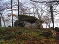
Dolmen

Church Plaisance


Web links
Commons : Plaisance - collection of images, videos and audio files