
Hollenthon
|
Hollenthon
|
||
|---|---|---|
| coat of arms | Austria map | |
 |
|
|
| Basic data | ||
| Country: | Austria | |
| State : | Lower Austria | |
| Political District : | Wiener Neustadt-Land | |
| License plate : | WB | |
| Surface: | 23.93 km² | |
| Coordinates : | 47 ° 35 ' N , 16 ° 16' E | |
| Height : | 661 m above sea level A. | |
| Residents : | 1.009 (January 1, 2020) | |
| Postcodes : | 2812, 2813, 2833 | |
| Area code : | 02645 | |
| Community code : | 3 23 12 | |
| NUTS region | AT122 | |
| Address of the municipal administration: |
Hollenthon 12 2812 Hollenthon |
|
| Website: | ||
| politics | ||
| Mayor : | Manfred Grundtner ( ÖVP ) | |
|
Municipal Council : ( 2020 ) (19 members) |
||
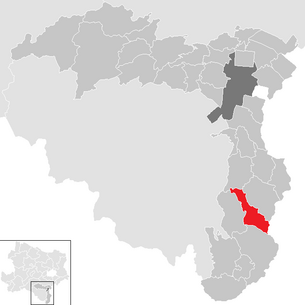
| Location of Hollenthon in the Wiener Neustadt-Land district | ||
  |
||
.jpg) Hollenthon municipal office |
||
| Source: Municipal data from Statistics Austria | ||

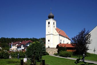
Hollenthon is a municipality with 1009 inhabitants (as of January 1, 2020) in the Wiener Neustadt-Land district in Lower Austria .
geography
Hollenthon is located in the Bucklige Welt , the southeastern part of the industrial district in Lower Austria. The area of the municipality covers 23.93 km², 47.95% of the area is forested.
The highest elevation in the municipality is the Stickelberg at 881 meters. Other notable elevations are the Hollenthoner Berg (745 meters), the Galgenriegel (740 meters), the Saurüssel (715 meters), the Ameisberg (710 meters), the Frohnriegel (710 meters), the Spratzecker Riegel (657 meters) and the Gleichenbacher Mountain (645 meters). The Hollenthoner Berg and the Galgenriegel also form the watershed between the Pitten and Rabnitz . At its deepest point, the Rabnitz origin, the municipality has a height of 418 meters.
The municipality is traversed in a south-easterly direction by the Spratzbach , which in the east forms the municipal border with Markt St. Martin and the state border with Burgenland . The south-western municipal boundary to Lichtenegg and Kirchschlag in the Bucklige Welt is formed by the Thalbach , which joins the Spratzbach in Blumau and from there forms the Rabnitz . The Schlattenbach forms the northeastern municipal boundary to Wiesmath . The Michelbach forms the northern boundary of the municipality with Bromberg .
.jpg)
Neighboring communities
| Bromberg | Wiesmath | |
| Lichtenegg |
.svg)
|
St. Martin market |
| Kirchschlag in the Bucklige Welt |
Community structure
.jpg)
.jpg)
The parish consists of the cadastral parish Hollenthon.
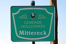
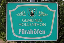
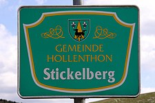
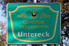
The municipality includes the following 14 localities and Rotten (population in brackets as of January 1, 2020):
- Blumau (35)
- Gleichenbach (112)
- Grohdorf (25)
- Hollenthon (424)
- Horndorf (27)
- Fiefdom (17)
- Michelbach (15)
- Middle corner (9)
- Obereck (50)
- Pürahöfen (8)
- Spratzau (44)
- Spratzeck (56)
- Stickelberg (176)
- Lower corner (11)
- Localities and Rotten
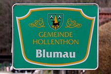
Blumau

Gleichenbach

Grohdorf
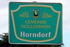
Horndorf
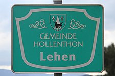
Fiefdom
.jpg)
.jpg)
.jpg)
.jpg)
.jpg)

Michelbach
Middle corner

Obereck
Pürahöfen

Spratzau
.jpg)
.jpg)
.jpg)
.jpg)
.jpg)

Spratzeck
Stickelberg
Lower corner
.jpg)
.jpg)
.jpg)
history


.jpg)
.jpg)
middle Ages
The origin of Hollenthon lies in the dark of history, but is in any case closely connected to the history of the Reichersberg monastery , to which the parish Hollenthon still belongs today. Conradus , Archbishop of Salzburg , had given away all the new fractional toe in 1144 in the " Pütner Forest " to Hartberg and up to the Hungarian border to the Reichersberg monastery. Until then, no towns were given. In 1295, Duke Albrecht I had the disputed border of the Aspang Regional Court ride through his "surrendered" knights , with Stickelberg being named as a fixed point for the border. In the second half of the 12th century Pertholdus de Stege is mentioned several times , who was probably a ministerial of the Styrian margrave. This "bridge" can no longer be located today because it was later removed . It is presumed to be in the Pitten area, as the named "von Stege" are mentioned again and again with those from Grimmenstein , Lanzenkirchen , Schwarzau , Emmerberg , Flatz and Klamm . In 1224 there is a Berthold von Treun in the documents , who defected to King Ottokar II from what was then still Hungarian Styria in 1260 . He was not only seriously ill, but also got into financial difficulties, which is why he left his "Castrum in Stickelberge" to the Bohemian King , who in return undertook to pay for his liabilities. An identity between Pertholdus de Stege and Berthold von Treun does not seem to be ruled out, but it remains to be seen whether “Stege” can be equated with Stickelberg or is to be found in the vicinity of the castle.
Modern times
According to tradition, Hollenthon was completely destroyed by the Turks in 1683 . Of the population, only those people who hid in a cave, the so-called Turkish cave, in the forest are said to have escaped. After Hollenthon had been a branch of the Lichtenegg parish since 1641 , it was raised to an independent parish in 1784 by court chancellery secret. The church was rebuilt as early as 1740 and completed in 1749. In the parish chronicle, Rupertus Mildner is named as the first pastor who also had the new rectory built. Leopold Derler was the first teacher mentioned in a document, who worked until 1785. A new school was built in 1793 on behalf of the Traiskirchen District Office .
In 1848 the rule of Stickelberg had to renounce all official rights over the "subjects of Stickelberg-Hollenthon".
1854 Foundation of the Stickelberg community
Due to the communal development, the municipality Stickelberg was established in 1854, which included the surrounding area including the village of Hollenthon. The resulting community had 124 houses with 965 inhabitants.
In 1861/62 a new school was built, which was expanded in 1886. This could be run in three classes. At the end of the 19th century, the roads to Bromberg, Gleichenbach, Spratzau and Wiesmath were expanded.
First republic
The consequences of the First World War were clearly felt in the community. At the beginning of the war, 53 men and boys had to enter. There was a shortage of male workers in agriculture and small businesses. Women and students had to do the field work. Horses, cattle, pigs and even chickens were registered. Animals had to be delivered again and again. Food was also confiscated and rationed. In 1917 the bells and organ pipes of the parish church and the branch churches were dismantled and taken away. 29 men and boys of the community had to kill him in the war. At the end of the war there was dire need. Numerous surreptitious traffickers , peddlers and beggars came from the urban areas in order to survive.
In 1921 numerous refugees from western Hungary moved through Hollenthon. The population was alarmed by Hungarian gangs, 40 of which were arrested by the gendarmerie .
At the request of the community council, the community name Stickelberg was changed to Hollenthon in 1927. The last meeting of the municipality council of Stickelberg took place on November 20, 1927 and the first meeting of the municipality council of Hollenthon took place on January 6, 1928 under the direction of Mayor Anton Panis .
National Socialism and World War II
In 1938 the Sturmabteilung also took over power in Hollenthon. The Horndorfer Franz Ernst was appointed as local leader. A year later men and boys had to enter the Second World War . Even deacon Josef Müller from Spratzau had to provide proof of Aryan status. Hollenthon was subsequently assigned to the Oberpullendorf district . Once again there was a lack of men in small businesses and agriculture, which is why the harvest had to be done by women and children.
On March 30, 1945, the Russian troops advanced through Wiesmath to Hollenthon and took the place and the surrounding area under fire. For a short time Hollenthon became an army camp of the Southwest Front (Red Army) . The rectory was used as a hospital and commandant's office. Looting was also on the agenda, as was stalking the female population. Numerous cattle were driven away. According to the information on the war memorial, the Second World War claimed 46 dead and 15 missing Hollenthoners.
Just one month after the end of the war (May 8, 1945), a local council was formed on June 8, headed by Johann Dörfler . It was not until February 1946 that the Soviet military police stopped the attacks by the occupation soldiers , so that orderly life returned to the community.
Second republic
In 1948 the community was reintegrated into the Kirchschlag judicial district. In the same year the construction of the parish hall began, which also housed the post office and the Raiffeisenkasse , which was opened at the end of May 1949.
In 1951 telephone lines to Gleichenbach, Spratzeck and Stickelberg were built and public telephone boxes were installed. In 1952 the localities and Rotten received new house numbers . The Hollenthon Volunteer Fire Brigade received its first fire engine in 1953 . A goods road was built between Hollenthon and Lichtenegg in 1954. As a result of the popular uprising in Hungary in 1956 Hungarian refugees passed through Hollenthon. After three years of construction and with a lot of personal contributions by the residents, a water pipe was built in Hollenthon and Spratzeck . In 1957 a local sewer system for rainwater was built in Hollenthon .
In April 1965 there were massive floods in the Spratzbachtal and Thalbachtal . In 1967 the newly built local chapel in Spratzeck was inaugurated. In 1968 the new elementary school was opened in Hollenthon; the roads to Wiesmath, Stickelberg and Lehen were paved . In 1968/69 the primary school was rebuilt in Gleichenbach. After the old chapel became dilapidated, the Fátima Church was rebuilt in Stickelberg ; the altar was consecrated on October 18, 1970. On January 5 and 10, 1972, Hollenthon was shaken by a magnitude six earthquake ; the earthquake in Pitten / Seebenstein with a magnitude of seven on April 16 was clearly felt. In 1975 street lighting was installed in Hollenthon .
The meanwhile closed elementary school Gleichenbach was converted into a kindergarten in 1983. The parish of Hollenthon celebrated its 200th anniversary in 1984. The newly built home at the rectory was ceremonially handed over to the Reichersberg Abbey . On May 3, 1987, after violent thunderstorms , massive flooding and damage occurred again in the Spratzbach and Thalbachtal valleys. The Hollenthon Volunteer Fire Brigade celebrated its 100th anniversary in 1991. For the anniversary she received a new fire truck with recovery equipment. After a field belonging to the parish was permanently rented by the parish, a sports facility consisting of a soccer field and two tennis courts was opened there in 1992. In the 1990s, the development of the elementary school settlement began. In 1995 the Hollenthon community celebrated its 700th anniversary.
Population development

religion
According to the data of the 2001 census , 96.9% of the population are Roman Catholic and 0.5% Protestant , 0.2% belong to Orthodox churches , and 1.7% of the population have no religious denomination.
politics
In the council there after the local elections of 26 January 2020 on a total of 19 seats following distribution of seats:
- Local council elections since 1990
St. = votes, M. = mandates
| Political party | GRW 2015 | GRW 2010 | GRW 2005 | GRW 2000 | GRW 1995 | GRW 1990 | ||||||||||||
|---|---|---|---|---|---|---|---|---|---|---|---|---|---|---|---|---|---|---|
| St. | % | M. | St. | % | M. | St. | % | M. | St. | % | M. | St. | % | M. | St. | % | M. | |
| ÖVP | 599 | 75.73 | 15th | 588 | 75.68 | 15th | 485 | 68.70 | 13 | 468 | 65.09 | 10 | 396 | 57.47 | 9 | 470 | 70.57 | 11 |
| SPÖ | 149 | 18.84 | 3 | 189 | 24.32 | 4th | 221 | 31.30 | 6th | 200 | 27.82 | 4th | 191 | 27.72 | 4th | 196 | 29.43 | 4th |
| FPÖ | 43 | 5.44 | 1 | not running | not running | 51 | 7.09 | 1 | 102 | 14.80 | 2 | not running | ||||||
| Eligible voters | 1007 | 985 | 944 | 928 | 895 | 875 | ||||||||||||
| voter turnout | 79.84% | 80.71% | 75.95% | 77.80% | 78.10% | 80.11% | ||||||||||||
- mayor
.jpg)
Mayor since 1945
| from | to | mayor |
|---|---|---|
| 1945 | 1955 | Johann Dörfler (†) |
| 1955 | 1961 | Johann Gradwohl (†) |
| 1961 | 1965 | Johann Koglbauer (†) |
| 1965 | 1972 | Heinrich Spenger (†) |
| 1972 | 1983 | Josef Seidl (†) |
| 1983 | 2000 | Manfred Kunisch (†) |
| 2000 | 2014 | Josef Birnbauer (1948-2018) |
| since 2014 | Manfred Grundtner |
coat of arms
|
|
The municipal coat of arms was awarded by the Lower Austrian provincial government under Governor Siegfried Ludwig at its meeting on March 3, 1992 .
Blazon : "A green shield, split by a stylized golden fir tree growing out of the base of the shield, in front of it a black basilisk turned right with a curled up spiked tail, a silver heraldic lily at the top right and left." The colors of the municipal flag derived from this municipal coat of arms are "green-yellow ". The fir tree should refer to the place name Hollenthon ("near the hollow fir tree"), the green of the sign to the abundance of forests in this area. The worm ( basilisk ) was derived from the coat of arms of the baron and later Count Wurmbrand , who acquired the Stickelberg castle ruins in 1607 and united them with their lordship in Steyersberg, which is still owned by the family today. The two heraldic lilies symbolize the parish church of the Assumption of Mary, which is dedicated to Queen Mary. |
Culture and sights
- Catholic parish church Hollenthon Mariä Himmelfahrt: The parish church was built according to the latest structural research in the second half of the 13th century. The oldest part is believed to be a castle tower belonging to the Stickelberg family , which was rededicated to the church's choir around 1300. The nave was added to this. The entrance to the church was originally on the south side and was only bricked up in the Baroque period . In the second half of the 15th century a military missile was placed on the existing still loopholes point. The church tower was also erected on the west side at this time . During the baroque period, the church was extensively rebuilt. The interior of the choir was rounded off and the church in its current form was vaulted. The organ parapet shows the year 1749 as the end of the baroque measures. The church was enclosed by a curtain wall, which used to be higher than the current wall. On the outside there was a moat to the east and south. The churchyard was used as a cemetery until 1878 .
- The church is dedicated to the patronage of the Assumption (August 15th). The picture on the main altar shows the Queen of Mary with the Infant Jesus in her arms. It is flanked by the apostles Peter and Paul .
- Spratzeck Chapel: When the first wooden chapel was built is not known. In 1967 the dilapidated chapel was demolished and today's chapel was built in its place. In the course of the demolition, a previously unnoticed wooden statue was discovered. This represents Salvator Mundi , the man of sorrows . The valuable 170 centimeter statue from 1479 is attributed to Thomas Strayff .
- Stickelberg castle ruins : The castle was first mentioned in 1259 in the will of Berthold von Treun , who bequeathed the castle to the sovereign. She stands on a ridge. The old curtain wall , which is 12 meters high and 120 to 180 centimeters thick, stretches around the edge of the mound . It had two entrances, which were secured with pulley drawbridges . The expansion of the inner wall suggests that it was the main line of defense. The Stickelberger Bach could be dammed at the back to create an additional obstacle. Around 1400 and around 1600 the castle was rebuilt and further strengthened. Presumably as a result of the union with Steyersberg , the castle deteriorated more and more over time. The introduction of the door and roof tax around 1810 also accelerated the decline.
Parish church Hollenthon Mariae Himmelfahrt
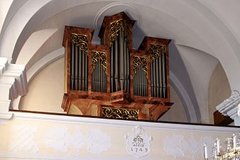
The organ parapet with the inscription from 1749

Spratzeck's Man of Sorrows
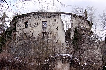
The Stickelberg castle ruins
.jpg)
.jpg)
.jpg)
.jpg)
Natural monuments
Turkish cave

Hanserlstein


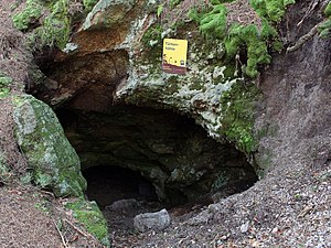
- Türkenhöhle - The quartzite cave is located in the local area of Hollenthon north of the Zehethof on private property. The entrance is 70 centimeters wide. The cave itself is between 200 and 270 centimeters wide. The length of the cave is eight meters. At the end of the cave there is a stalactite . Due to the advancing sedimentation, the cave is only low in height. It is therefore only possible to crawl or crouch.
- The name goes back to the Turkish invasion of 1683, when Hollenthon was completely destroyed according to tradition. Only the local residents who found refuge in the cave got away with their lives.
- Hanserlstein - The Hanserlstein is located in the local area of Spratzeck on the slope of the Hofstattbach valley on private property.
- The name goes back to a legend according to which the 14-year-old Hanserl, who drove the farmer's cows to pasture, repeatedly climbed the rock to shout some words and then listened to the echo. The otherwise good boy had the bad quality of being able to swear loudly, for which he was often admonished and punished by his parents. One day he was sitting on the boulder again and wanted to eat his sandwich. It fell out of his hand and slipped into a crack in the rock, whereupon he loudly cursed "the devil should get it". As soon as the curse was pronounced, the rock split and Hanserl slipped into it and disappeared. The rock closed behind him. When the cows returned to the farm alone in the evening, the farmers sent the farmhand to look for Hanserl. As he got near the boulder, he heard terrible moans and screams that went through his marrow and bone. He stopped with a shudder. After a while the whining started again and the servant realized that it was Hanserl's voice. Shuddering, he ran home and told the farmers what he had experienced. While the farmer's wife and children began to cry, the farmer just said “the devil has brought him”. The screaming could be heard for three days and three nights before it stopped. Since then, the people of Spratzeck have called the rock "Hanserlstein".
Hallway and small monuments
In the municipality of Hollenthon there are 28 land monuments, almost all of which are privately owned. A land monument, the Antoniusmarterl, was removed while the road to Spratzeck was being built. First and foremost, the crosses and martyrs recall personal events such as accidents or tragic deaths. General gratitude or piety were just as much a motivation for the establishment as rescue from dangerous situations.
| Name of the monument | place | location | Description, note | image |
|---|---|---|---|---|
| Wegscheider Cross (also Snow White Cross) | Gleichenbach | 47.558982 ° N, 16.300613 ° E | Concrete column with an iron cross, in the wayside shrine a statue of the Virgin Mary from Medjugorje , erected before 1945 after an accident. | |
| Cobbler Chapel | Grohdorf | 47.559409 ° N, 16.272801 ° E | Erected in 1886 in place of the previous forge, renovated in 1983, chapel with canopy and statue of the Virgin Mary based on the model from Lourdes . | |
| Vollnhofer Chapel (formerly Bauernmüller-Kreuz) | Grohdorf | 47.547836 ° N, 16.297754 ° E | Establishment not known, renovated in 1992, stone masonry chapel, cross with corpus, statue of Francis with child Jesus, statue of the Virgin Mary. |
.jpg)
|
| Floriani Chapel (also Spenger Chapel) | Hollenthon | 47.594223 ° N, 16.258612 ° E | St. Florian. | |
| Chapel at the Rosenhof (also Panis Chapel) | Hollenthon | 47.586531 ° N, 16.259596 ° E | built in 1848, rebuilt after 1945. | |
| Cross fountain | Hollenthon | 47.590047 ° N, 16.258964 ° E | Virgin Mary statue. | |
| Schabauer Chapel | Hollenthon | 47.590541 ° N, 16.261974 ° E | Heart Mary picture. | |
| Zehetbauer Chapel | Hollenthon | 47.593694 ° N, 16.256391 ° E | Mary in a field. | |
| Ernstkreuz | Horndorf | The cross recalls the family tragedy Ernst. | ||
| Horndorf Chapel | Horndorf | 47.586471 ° N, 16.26689 ° E | Construction unknown, rebuilt in 1990. | |
| Rendlbauer Wegkapelle | Fiefdom | 47.590745 ° N, 16.248992 ° E | Cross with body and statue of the Virgin Mary. | |
| Tower builder way chapel | Fiefdom | 47.592815 ° N, 16.242061 ° E | Cross with body, restored in 1994. | |
| Gullenbauer Chapel | Middle corner | 47.566131 ° N, 16.278274 ° E | The largest of all the wayside chapels, walled up with stones, a 150 centimeter wooden cross, erected in 1727, renovated in 1914 and 1992. |
.jpg)
|
| Beistein's picture tree | Obereck | 47.56604 ° N, 16.254115 ° E | Image of the Virgin Mary with baby Jesus on ivy-covered linden tree. | |
| Dornleitner Chapel | Obereck | 47.565141 ° N, 16.251996 ° E | original chapel demolished by lightning, demolished in 1962 by road construction and rebuilt, rebuilt again in 1987. | |
| Führinger chapel | Obereck | 47.571018 ° N, 16.256412 ° E | The chapel commemorates an accident in 1903 in which a farmer was killed while cutting an oak tree. |
.jpg)
|
| Lorenz wayside shrine | Obereck | 47.56833 ° N, 16.25635 ° E | The wayside shrine, dated May 1, 1921, commemorates an accident in which a guardian boy was struck by lightning. This is interesting insofar as it still bears the former community name Stickelberg on the inscription plate. | |
| Schwarz-Spitzer Chapel | Obereck | 47.568926 ° N, 16.266368 ° E | Construction unknown, renovated in the 1970s, stone masonry chapel with statue of the Virgin Mary. | |
| Bildbaum Pichergraben | Spratzau | mighty larch with image of Mary. | ||
| Puchegger Marienkapelle | Spratzau | 47.581781 ° N, 16.25403 ° E | Grotto-like Lady Chapel from 1954. | |
| Johannesmarterl | Spratzeck | 47.5745 ° N, 16.28619 ° E | Wayside shrine St. John, rebuilt in 1991 after an accident | |
| Pastor's Cross | Spratzeck | 47.582794 ° N, 16.267045 ° E | formerly also "red cross", erected in 1891. | |
| Stockbauer cross | Spratzeck | 47.580205 ° N, 16.272298 ° E | Built in 1977 instead of a chapel. | |
| Image tree I | Stickelberg | on the old church path (the so-called "Kuhdrift") from Stickelberg to Hollenthon, face of Christ with a crown of thorns punched from sheet metal, origin unknown. | ||
| Image tree II | Stickelberg | on the old church path (the so-called "Kuhdrift") from Stickelberg to Hollenthon, Maria with the infant Jesus punched out of sheet metal, origin unknown. | ||
| Filzmichl wayside shrine | Lower corner | 47.562054 ° N, 16.289624 ° E | Wayside shrine with Mary woodcut, erected in 1980. | |
| Hubertus Chapel | Lower corner | 47.563207 ° N, 16.292051 ° E | open chapel made of stone masonry, built in 1983, formerly Hubertus masses, today May devotions. | |
| Fuchs'n Marienkapelle | Michelbach | 47.625614 ° N, 16.225313 ° E | The chapel belongs to the Michelbach 22 house (municipality of Bromberg), but it is on Hollenthoner Grund; domed chapel in front of a fountain, built in 1986. |
Weather trail

Weather crosses with a view of the place

One of the ten stations

Weather station with webcams
Panoramic window with explanation of the surroundings
.jpg)
.jpg)
.jpg)
.jpg)
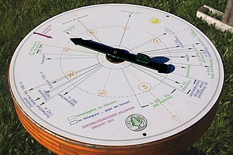
The first Austrian educational weather trail was built by the Hollenthon Village Renewal Association based on an idea by meteorologist Martin Puchegger and opened in 2008. The establishment was preceded by intensive planning and scientific discussion. In contrast to projects in other countries, that of Hollenthon is particularly detailed and therefore unique because the meteorological phenomena are presented not only for adults, but also in a child-friendly manner. As a result, the nature trail is becoming a popular destination for school classes, who receive clear lessons here.
There are ten themed boards and a general information board at the beginning along the around one kilometer long circular route, which can be walked free of charge. In addition, since 2010 some stations have been equipped with action facilities such as water vapor condenser, lightning generator, thunder plate, blow strength meter, rain noise tube, panorama window or optical disk with which weather phenomena can be understood. Since there is only a difference in altitude of 50 meters, the nature trail is easy to walk on. The start and finish of the nature trail is at the municipal office. There are three weather crosses at the highest point of the route. This point also offers a wonderful view of the main town of the municipality. To better understand the facilities, it is recommended that you allow two to three hours for the circular route. In return for a donation , the village renewal association offers guided tours by a knowledgeable layperson. Guided tours by the meteorologist on the weather trail are also possible, but these have to be paid for as he has to travel from Vienna.
Economy and Infrastructure
In 2001 there were 22 non-agricultural workplaces, agricultural and forestry operations 91 according to the 1999 survey. According to the 2001 census, the number of people in work at the place of residence was 473. The 2001 participation rate was 46.08%.
education
.jpg)
There is a Lower Austria state kindergarten for preschool children in Gleichenbach. The former school building was renovated and adapted for this purpose.
There is a three-class elementary school in Hollenthon . While the first and second grades are taught separately, the third and fourth grades are taught together.
After the fourth grade, students can attend the New Middle School in Lichtenegg or the Gymnasium in Wiener Neustadt .
Personalities

Honorary citizen
source
- Anton Spenger, Former Mayor (1951)
- Philipp Koglbauer, Former Vice Mayor (1951)
- Josef Dienbauer, Member of the Lower Austrian State Parliament, for services to the electrification of Hollenthon (1951)
- Max Jung, lecturer, for contributions to the financing of the Hollenthon water supply (1955)
- Guido Chwistek, for contributions to the financing of the Hollenthon local water system (1955)
- Johann Dörfler, Former Mayor (1958)
- Andreas Maurer , Governor, for services to road construction (1977)
- Josef Seidl, Former Mayor (1983)
- Cardinal Alfons Maria Stickler (1986)
- Manfred Kunisch, Former Mayor (2008)
- Josef Birnbauer, Former Mayor (2014)
Honorary ring bearer
source
- Walter Komberg, for decades of expert work at building commissions (1980)
Sons and daughters of the church
- Alois Schwarz (* 1952), Bishop of St. Pölten
literature
- Homeland book of the Hollenthon parish, 700 years of Hollenthon, published by Hollenthon parish, 1995 (without ISBN)
Others
A Vienna Symphonic - death metal band named after the municipality of Hollenthon, see Hollenthon (band) .
Web links
- Hollenthon municipality: Official website of the municipality
- Hollenthon parish: Hollenthon web and weather camera
- 32312 - Hollenthon. Community data, Statistics Austria .
Individual evidence
- ↑ Statistics Austria: Population on January 1st, 2020 by locality (area status on January 1st, 2020) , ( CSV )
- ↑ a b c d e f g h i j k Municipality of Hollenthon: Heimatbuch, pages 249ff; Hollenthon 1995
- ↑ a b c d e f g h Hollenthon community: Heimatbuch, pages 53ff; Hollenthon 1995
- ↑ a b Province of Lower Austria: Municipal Council Election 2015 ( Memento from August 24, 2016 in the Internet Archive ) (accessed on August 24, 2016)
- ↑ a b Hollenthon municipality: municipal council election 2005 (accessed on August 24, 2016)
- ↑ a b Province of Lower Austria: municipal council elections 1995 (accessed on August 27, 2016)
- ^ Community Hollenthon: Heimatbuch, page 13; Hollenthon 1995
- ^ Hollenthon parish: Heimatbuch, pages 10, 11; Hollenthon 1995
- ^ Community Hollenthon: Heimatbuch, pages 222ff ; Hollenthon 1995
- ^ Hollenthon community: Heimatbuch, page 98 ; Hollenthon 1995
- ^ Community Hollenthon: Heimatbuch, pages 39ff ; Hollenthon 1995
- ↑ a b Hollenthon community: Heimatbuch, page 33 ; Hollenthon 1995
- ↑ Village renewal association Hollenthon: The Turkish Cave (accessed on August 25, 2016)
- ^ Hollenthon community: Heimatbuch, page 250 ; Hollenthon 1995
- ^ Hollenthon community: Heimatbuch, pages 310/311 ; Hollenthon 1995
- ^ Community Hollenthon: Heimatbuch, pages 99ff ; Hollenthon 1995
- ↑ a b Village renewal association Hollenthon: Weather trail (accessed on August 25, 2016)
- ↑ Hollenthon primary school: Klassen (accessed on September 6, 2016)
- ↑ a b Hollenthon municipality: Heimatbuch, page 14; Hollenthon 1995

Bad Erlach | Bad Fischau-Brunn | Bad Schönau | Bromberg | Ebenfurth | Eggendorf | Felixdorf | Gutenstein | Hochneukirchen-Gschaidt | Hochwolkersdorf | High wall | Hollenthon | Katzelsdorf | Kirchschlag in the Bucklige Welt | Krumbach | Lanzenkirchen | Lichtenegg | Lichtenwörth | Market Piesting | Matzendorf-Hölles | Miesenbach | Muggendorf | Pernitz | Pipe in the mountains | Schwarzenbach | Sollenau | Theresienfeld | Waidmannsfeld | Waldegg | Walpersbach | Weikersdorf am Steinfelde | Wiesmath | Winzendorf-Muthmannsdorf | Wöllersdorf-Steinabrückl | Zillingdorf
Cadastral parishes : Hollenthon
Locations: Blumau | Gleichenbach | Grohdorf | Hollenthon | Horndorf | Fiefdom | Michelbach | Middle corner | Obereck | Pürahöfen | Spratzau | Spratzeck | Stickelberg | Lower corner
Villages: Gleichenbach | Hollenthon | Fiefdom | Pürahöfen | Spratzau | Spratzeck | Stickelberg | Hamlet: farmer's mill | Felt mill | Mittereck Rotten: Blumau | Hollenthoner-Spratzau | Horndorf | Michelbach | Obereck | Untereck Other locations: Grohdorf | Fiefdom | Pürahöfen
Counting district: Hollenthon