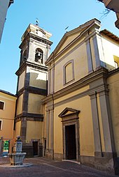
Supino
| Supino | ||
|---|---|---|

|
|
|
| Country | Italy | |
| region | Lazio | |
| province | Frosinone (FR) | |
| Coordinates | 41 ° 37 ' N , 13 ° 14' E | |
| height | 321 m slm | |
| surface | 35 km² | |
| Residents | 4,828 (Dec 31, 2019) | |
| Population density | 138 inhabitants / km² | |
| Post Code | 03019 | |
| prefix | 0775 | |
| ISTAT number | 060076 | |
| Popular name | Supinesi | |
| Patron saint | San Cataldo | |
| Website | Supino | |
 Panorama of Supino |
||
Supino is an Italian commune in the province of Frosinone in the Lazio region with 4828 inhabitants (as of December 31, 2019). It is located 81 km southeast of Rome and 15 km west of Frosinone .
geography
Supino lies on a hill above the Saccotal . It is dominated by the towering Monti Lepini . It is a member of the Comunità Montana Monti Lepini, Ausoni e Valliva .
The neighboring towns are Carpineto Romano ( RM ), Ferentino , Frosinone , Giuliano di Roma , Gorga (RM), Maenza ( LT ), Morolo and Patrica .
traffic
Supino is 13 km from the A1 Autostrada del Sole motorway , Frosinone exit.
With the Ferentino-Supino train station , 6 km from the center, the town is on the Rome - Naples railway line.
Population development
| year | 1881 | 1901 | 1921 | 1936 | 1951 | 1971 | 1991 | 2001 |
|---|---|---|---|---|---|---|---|---|
| Residents | 3.134 | 4,264 | 4,867 | 5,275 | 5,423 | 3,927 | 4,749 | 4,783 |
Source: ISTAT
politics
Alessandro Foglietta (list of citizens) was elected mayor in May 2006.
Twin cities
Web links
- La Ciociaria (Italian)
- Supino on www.comuni-italiani.it (Italian)
- San Cataldo (Italian)
Individual evidence
- ↑ Statistiche demografiche ISTAT. Monthly population statistics of the Istituto Nazionale di Statistica , as of December 31 of 2019.


