
Vikantice
| Vikantice | |||||
|---|---|---|---|---|---|
|
|||||
| Basic data | |||||
| State : |
|
||||
| Region : | Olomoucký kraj | ||||
| District : | Šumperk | ||||
| Area : | 1003 ha | ||||
| Geographic location : | 50 ° 8 ′ N , 16 ° 59 ′ E | ||||
| Height: | 613 m nm | ||||
| Residents : | 68 (Jan. 1, 2019) | ||||
| Postal code : | 788 25 | ||||
| License plate : | M. | ||||
| traffic | |||||
| Street: | Hanušovice - Branná | ||||
| structure | |||||
| Status: | local community | ||||
| Districts: | 1 | ||||
| administration | |||||
| Mayor : | Miroslav Kročil (as of 2008) | ||||
| Address: | Vikantice 131 788 25 Branná |
||||
| Municipality number: | 553191 | ||||
| Website : | www.nasemorava.cz/vikantice | ||||


Vikantice (German Weigelsdorf ) is a municipality in the Czech Republic . It is located eight kilometers northeast of Hanušovice and belongs to the Okres Šumperk .
geography
Vikantice is located at the southwestern foot of the Jeseníky Mountains in the old town-Goldensteiner Kessel. The Štolný hřbet ( Stollekamm , 882 m) rises to the east, the Losín ( Hirschenstein , 726 m) and Peklo (649 m) to the southeast, the Rudný vrch ( Erzberg , 628 m) to the south, and the Vikantický vrch ( Weigelsberg , 637 m ) to the south-west ) and in the northwest of the Dvorský vrch ( Hofberg , 702 m).
Neighboring towns are Šléglov in the north, Branná , Dolce and Přední Alojzov in the Northeast, Nová Branná and Františkov the east, Nové Losiny in the southeast, Pleče and Rudkov in the south, Habartice and Vysoké Žibřidovice in the southwest, Chrastice to the west and Štěpánov and Stare Mesto in the northwest .
history
The first written mention of the village belonging to the Goldenstein rule was in 1437.
After the abolition of patrimonial formed Weigelsdorf / Vigantice with the districts Bergthal basic and hares Dörfl from 1850, a municipality in the district Šumperk . Weigelsdorf consisted of 99 houses in 1900 and had 684 German-speaking residents. Graphite mining was carried out near Weigelsdorf. In 1930 the community had 861 inhabitants.
After the Munich Agreement , Weigelsdorf was added to the German Reich in 1938 and belonged to the Mährisch Schönberg district until 1945 . In 1939 831 people lived in the village. After the end of the Second World War, the German residents were expelled .
In 1950, Šléglov and Kronfelzov were incorporated . From 1975 to 1990 the village belonged to Branná . In 1990 the municipality of Vikantice was established with the district Šléglov. At the beginning of 1992, Šléglov broke up with Kronfelzov and formed its own community. The population in the municipality continues to decline, there are no jobs in the village.
Community structure
No districts are shown for the municipality of Vikantice.
Attractions
- Filial church St. Wolfgang, Renaissance building from the 16th century
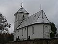
Filial church St. Wolfgang
