
Bela Crkva: Difference between revisions
No edit summary Tags: Mobile edit Mobile web edit |
→See also: the see also section is for /topics/ that are related, not /names/ that are similar. That is the job of hatnotes and dab pages - and this article is already linked in the dab page that is linked in the hatnote of this article |
||
| (14 intermediate revisions by 9 users not shown) | |||
| Line 1: | Line 1: | ||
{{Other uses}} |
{{Other uses}} |
||
{{Redirect|Biserica Albă| |
{{Redirect|Biserica Albă|churches or places that bear this name in Romanian|White Church (disambiguation){{!}}White Church}} |
||
{{Infobox settlement |
{{Infobox settlement |
||
| name |
| name = Bela Crkva |
||
| native_name |
| native_name = {{native name|sr-Cyrl|Бела Црква|italics=off}}<br />{{native name|ro|Biserica Albă}} |
||
| image_skyline |
| image_skyline = {{Photomontage|position=center |
||
|photo1a =Wiki.Vojvodina VI Bela Crkva 645.jpg |
|photo1a =Wiki.Vojvodina VI Bela Crkva 645.jpg |
||
|photo1b =Wiki.Vojvodina VI Bela Crkva 664.jpg |
|photo1b =Wiki.Vojvodina VI Bela Crkva 664.jpg |
||
| Line 19: | Line 19: | ||
|border = 1 |
|border = 1 |
||
}} |
}} |
||
| imagesize |
| imagesize = |
||
| image_caption |
| image_caption = Bela Crkva |
||
| image_flag |
| image_flag = |
||
| image_shield |
| image_shield = Blason_de_Bela_Crkva.png |
||
| image_map |
| image_map = Municipalities of Serbia Bela Crkva.png |
||
| mapsize |
| mapsize = |
||
| map_caption |
| map_caption = Location of Bela Crkva within Serbia |
||
| settlement_type |
| settlement_type = [[List of cities in Serbia|Town]] and [[Municipalities and cities of Serbia|municipality]] |
||
| subdivision_type |
| subdivision_type = Country |
||
| subdivision_name |
| subdivision_name = {{SRB}} |
||
| subdivision_type1 |
| subdivision_type1 = [[Subdivisions of Serbia|Province]] |
||
| subdivision_name1 |
| subdivision_name1 = {{flag|Vojvodina}} |
||
| subdivision_type2 |
| subdivision_type2 = [[Districts of Serbia|District]] |
||
| subdivision_name2 |
| subdivision_name2 = [[South Banat District|South Banat]] |
||
| subdivision_type3 |
| subdivision_type3 = [[Municipalities of Serbia|Municipalities]] |
||
| subdivision_name3 |
| subdivision_name3 = |
||
| leader_title |
| leader_title = Mayor |
||
| leader_name |
| leader_name = Violeta Simić ([[Serbian Progressive Party|SNS]]) |
||
| established_title |
| established_title = |
||
| established_date |
| established_date = |
||
| established_title1 |
| established_title1 = |
||
| established_date1 |
| established_date1 = |
||
| established_title2 |
| established_title2 = |
||
| established_date2 |
| established_date2 = |
||
| area_blank1_title = Town |
| area_blank1_title = Town |
||
| area_blank1_km2 |
| area_blank1_km2 = 38.82 |
||
| area_blank2_title = Municipality |
| area_blank2_title = Municipality |
||
| area_blank2_km2 |
| area_blank2_km2 = 353.34 |
||
| population_footnotes = <ref>{{Serbian census 2011}}</ref> |
| population_footnotes = <ref>{{Serbian census 2011}}</ref> |
||
| population_as_of |
| population_as_of = 2011 census |
||
| population_blank1_title = Town |
| population_blank1_title = Town |
||
| population_blank1 = 8868 |
| population_blank1 = 8868 |
||
| Line 55: | Line 55: | ||
| population_blank2 = 17285 |
| population_blank2 = 17285 |
||
| population_density_blank2_km2 = auto |
| population_density_blank2_km2 = auto |
||
| timezone |
| timezone = [[Central European Time|CET]] |
||
| utc_offset |
| utc_offset = +1 |
||
| timezone_DST |
| timezone_DST = [[Central European Summer Time|CEST]] |
||
| utc_offset_DST |
| utc_offset_DST = +2 |
||
| coordinates |
| coordinates = {{coord|44|53|51|N|21|25|01|E|region:RS|display=inline,title}} |
||
| elevation_footnotes |
| elevation_footnotes = |
||
| elevation_m |
| elevation_m = 78 |
||
| elevation_ft |
| elevation_ft = |
||
| postal_code_type |
| postal_code_type = Postal code |
||
| postal_code |
| postal_code = 26340 |
||
| area_code |
| area_code = [[Telephone numbers in Serbia|+381(0)13]] |
||
| website |
| website = www.belacrkva.rs |
||
| blank_name |
| blank_name = [[Vehicle registration plates of Serbia|Car plates]] |
||
| blank_info |
| blank_info = VŠ |
||
| module |
| module = {{Infobox mapframe |wikidata=yes |zoom=10 |frame-height=300 | stroke-width=1 |shape-fill-opacity=0.2 |coord={{WikidataCoord|display=i}}}} |
||
}} <!-- Infobox ends --> |
}} <!-- Infobox ends --> |
||
[[File:Bela crkva mun.png|right|thumb|280px|Map of Bela Crkva municipality]] |
[[File:Bela crkva mun.png|right|thumb|280px|Map of Bela Crkva municipality]] |
||
'''Bela Crkva''' ({{lang-sr-cyrl|Бела Црква}}, {{IPA-sh|bɛ̂ːlaː tsr̩̂ːkv̞a|pron}}; {{lang-de|Weißkirchen}}; {{lang-hu|Fehértemplom}}; {{lang-ro|Biserica Albă}}) is a town and municipality located in the [[South Banat District]] of the autonomous province of [[Vojvodina]], Serbia. The town has a population of 8,868, while the Bela Crkva municipality has 17,285 inhabitants. |
'''Bela Crkva''' ({{lang-sr-cyrl|Бела Црква}}, {{IPA-sh|bɛ̂ːlaː tsr̩̂ːkv̞a|pron}}; {{lang-de|Weißkirchen}}; {{lang-hu|Fehértemplom}}; {{lang-ro|Biserica Albă}}) is a town and municipality located in the [[South Banat District]] of the autonomous province of [[Vojvodina]], [[Serbia]]. The town has a population of 8,868, while the Bela Crkva municipality has 17,285 inhabitants. |
||
[[Bela Crkva lakes]] at the outskirts of the town are a popular summer [[Tourism|tourist]] destination. |
[[Bela Crkva lakes]] at the outskirts of the town are a popular summer [[Tourism|tourist]] destination. |
||
==Name== |
==Name== |
||
The name of the town ''Bela Crkva'' means "white church" in [[ |
The name of the town ''Bela Crkva'' means "white church" in [[English language|English]]. In [[Romanian language|Romanian]], the town is known as ''Biserica Albă'' (formerly Albești), in [[German language|German]] as ''Weißkirchen'', in [[Hungarian language|Hungarian]] as ''Fehértemplom'' (formerly Fejéregyház<ref name="Apor2014">{{cite book|author=Apor|title=Metamorphosis Transylvaniae|url=https://books.google.com/books?id=ZktpAwAAQBAJ&pg=PR20|date=23 April 2014|publisher=Routledge|isbn=978-1-317-85664-1|pages=20–}}</ref>), and in [[Turkish language|Turkish]] as ''Aktabya''. |
||
==History== |
==History== |
||
[[Neolithic]] findings of [[ceramic]]s and burial with Greek-style pots dating to late fifth century |
[[Neolithic]] findings of [[ceramic]]s and burial with Greek-style pots dating to late fifth century BCE have been found in the area.<ref>The Illyrians-John Wilkes</ref> |
||
The town was founded in 1717 when this region was included into the [[Habsburg monarchy]]. It was part of the [[Banat Krajina|Banatian Military Frontier]] of the Monarchy and, since 1774, was a seat of the [[Illyrians|Illyrian]] (Serbian) section of the Banatian Frontier. Briefly, in 1787–1788, the town was controlled by the Ottomans. In 1848–1849, the town was part of autonomous [[Serbian Vojvodina]], but in 1849 it was again placed under military administration. With the abolishment of the Military Frontier, the town was included into [[Temes County|Temes]] county of the [[Kingdom of Hungary]], one of two autonomous parts of [[Austria-Hungary]]. The town was also a seat of the district since 1867. |
The town was founded in 1717 when this region was included into the [[Habsburg monarchy]]. It was part of the [[Banat Krajina|Banatian Military Frontier]] of the Monarchy and, since 1774, was a seat of the [[Illyrians|Illyrian]] (Serbian) section of the Banatian Frontier. Briefly, in 1787–1788, the town was controlled by the Ottomans. In 1848–1849, the town was part of autonomous [[Serbian Vojvodina]], but in 1849 it was again placed under military administration. With the abolishment of the Military Frontier, the town was included into [[Temes County|Temes]] county of the [[Kingdom of Hungary]], one of two autonomous parts of [[Austria-Hungary]]. The town was also a seat of the district since 1867. |
||
| Line 86: | Line 86: | ||
According to the 1910 census, the town itself was mainly populated by [[Germans]] with a group of [[French people|French]]<ref>[http://acta.bibl.u-szeged.hu/20789/1/szephalom_009_003-008.pdf István Németh - A magyarországi francia telepek]</ref>{{dubious|date=May 2020}}{{better source needed|date=May 2020}}, but its surrounding municipal area was mainly populated by [[Serbs]]. Census recorded 11,524 citizens in the town, of whom 6,062 spoke German language, 1,994 Serbian, 1,806 Romanian, and 1,213 Hungarian. The municipal area numbered 36,831 inhabitants, of whom 20,987 spoke [[Serbian language|Serbian]], 8,234 [[Romanian language|Romanian]], and 4,791 [[German language|German]]. The total population of the town and its municipal area counted together was 48,355, of whom 22,981 spoke Serbian, 10,853 German, 10,040 Romanian, and 2,122 [[Hungarian language|Hungarian]].<ref>{{cite web |title=Temes County |url=http://www.talmamedia.com/php/district/district.php?county=Temes |archive-url=https://web.archive.org/web/20060309202200/http://www.talmamedia.com/php/district/district.php?county=Temes |archive-date=March 9, 2006 |website=www.talmamedia.com}}</ref> |
According to the 1910 census, the town itself was mainly populated by [[Germans]] with a group of [[French people|French]]<ref>[http://acta.bibl.u-szeged.hu/20789/1/szephalom_009_003-008.pdf István Németh - A magyarországi francia telepek]</ref>{{dubious|date=May 2020}}{{better source needed|date=May 2020}}, but its surrounding municipal area was mainly populated by [[Serbs]]. Census recorded 11,524 citizens in the town, of whom 6,062 spoke German language, 1,994 Serbian, 1,806 Romanian, and 1,213 Hungarian. The municipal area numbered 36,831 inhabitants, of whom 20,987 spoke [[Serbian language|Serbian]], 8,234 [[Romanian language|Romanian]], and 4,791 [[German language|German]]. The total population of the town and its municipal area counted together was 48,355, of whom 22,981 spoke Serbian, 10,853 German, 10,040 Romanian, and 2,122 [[Hungarian language|Hungarian]].<ref>{{cite web |title=Temes County |url=http://www.talmamedia.com/php/district/district.php?county=Temes |archive-url=https://web.archive.org/web/20060309202200/http://www.talmamedia.com/php/district/district.php?county=Temes |archive-date=March 9, 2006 |website=www.talmamedia.com}}</ref> |
||
In the 1920s, it was a center of Russian [[emigration]] in Yugoslavia.{{cn|date=September 2023}} |
|||
Between 1918 and 1945 Bela Crkva was part of the [[Kingdom of Yugoslavia]]. From 1945 until 1992 it was part of the [[Socialist Federal Republic of Yugoslavia]]. From 1992-2006 it was part of [[Serbia and Montenegro]]. Since 2006 it has been part of the independent republic of Serbia. |
|||
==Inhabited places== |
==Inhabited places== |
||
| Line 168: | Line 170: | ||
File:Lake of Bela Crkva.jpg|One of the lakes of Bela Crkva |
File:Lake of Bela Crkva.jpg|One of the lakes of Bela Crkva |
||
</gallery> |
</gallery> |
||
==Notable individuals== |
|||
* [[Žarko Vasiljević]]<ref name="Jugoslovenski književni leksikon">{{cite book |author1=Draško Ređep |editor = Živan Milisavac |date=1971 |title=Jugoslovenski književni leksikon |trans-title=Yugoslav Literary Lexicon |publisher=[[Matica srpska]] |location= [[Novi Sad]] ([[Socialist Autonomous Province of Vojvodina|SAP Vojvodina]], [[Socialist Republic of Serbia|SR Serbia]] |page=557 }}</ref> |
|||
==See also== |
==See also== |
||
* [[List of places in Serbia]] |
* [[List of places in Serbia]] |
||
* [[List of cities, towns and villages in Vojvodina]] |
* [[List of cities, towns and villages in Vojvodina]] |
||
* [[Bila Tserkva]] |
|||
== References == |
== References == |
||
Latest revision as of 11:07, 14 April 2024
Bela Crkva
| |
|---|---|
Town and municipality | |
         Bela Crkva | |
 Coat of arms | |
 Location of Bela Crkva within Serbia | |
| Coordinates: 44°53′51″N 21°25′01″E / 44.89750°N 21.41694°E | |
| Country | |
| Province | |
| District | South Banat |
| Government | |
| • Mayor | Violeta Simić (SNS) |
| Area | |
| • Town | 38.82 km2 (14.99 sq mi) |
| • Municipality | 353.34 km2 (136.43 sq mi) |
| Elevation | 78 m (256 ft) |
| Population (2011 census)[1] | |
| • Town | 8,868 |
| • Town density | 230/km2 (590/sq mi) |
| • Municipality | 17,285 |
| • Municipality density | 49/km2 (130/sq mi) |
| Time zone | UTC+1 (CET) |
| • Summer (DST) | UTC+2 (CEST) |
| Postal code | 26340 |
| Area code | +381(0)13 |
| Car plates | VŠ |
| Website | www.belacrkva.rs |
 | |

Bela Crkva (Serbian Cyrillic: Бела Црква, pronounced [bɛ̂ːlaː tsr̩̂ːkv̞a]; German: Weißkirchen; Hungarian: Fehértemplom; Romanian: Biserica Albă) is a town and municipality located in the South Banat District of the autonomous province of Vojvodina, Serbia. The town has a population of 8,868, while the Bela Crkva municipality has 17,285 inhabitants.
Bela Crkva lakes at the outskirts of the town are a popular summer tourist destination.
Name[edit]
The name of the town Bela Crkva means "white church" in English. In Romanian, the town is known as Biserica Albă (formerly Albești), in German as Weißkirchen, in Hungarian as Fehértemplom (formerly Fejéregyház[2]), and in Turkish as Aktabya.
History[edit]
Neolithic findings of ceramics and burial with Greek-style pots dating to late fifth century BCE have been found in the area.[3]
The town was founded in 1717 when this region was included into the Habsburg monarchy. It was part of the Banatian Military Frontier of the Monarchy and, since 1774, was a seat of the Illyrian (Serbian) section of the Banatian Frontier. Briefly, in 1787–1788, the town was controlled by the Ottomans. In 1848–1849, the town was part of autonomous Serbian Vojvodina, but in 1849 it was again placed under military administration. With the abolishment of the Military Frontier, the town was included into Temes county of the Kingdom of Hungary, one of two autonomous parts of Austria-Hungary. The town was also a seat of the district since 1867.
According to the 1910 census, the town itself was mainly populated by Germans with a group of French[4][dubious ][better source needed], but its surrounding municipal area was mainly populated by Serbs. Census recorded 11,524 citizens in the town, of whom 6,062 spoke German language, 1,994 Serbian, 1,806 Romanian, and 1,213 Hungarian. The municipal area numbered 36,831 inhabitants, of whom 20,987 spoke Serbian, 8,234 Romanian, and 4,791 German. The total population of the town and its municipal area counted together was 48,355, of whom 22,981 spoke Serbian, 10,853 German, 10,040 Romanian, and 2,122 Hungarian.[5]
In the 1920s, it was a center of Russian emigration in Yugoslavia.[citation needed]
Between 1918 and 1945 Bela Crkva was part of the Kingdom of Yugoslavia. From 1945 until 1992 it was part of the Socialist Federal Republic of Yugoslavia. From 1992-2006 it was part of Serbia and Montenegro. Since 2006 it has been part of the independent republic of Serbia.
Inhabited places[edit]
Bela Crkva municipality includes the town of Bela Crkva and the following villages:
- Banatska Palanka
- Banatska Subotica
- Vračev Gaj
- Grebenac
- Dobričevo
- Dupljaja
- Jasenovo
- Kajtasovo
- Kaluđerovo
- Kruščica
- Kusić
- Crvena Crkva
- Češko Selo
Demographics[edit]
| Year | Pop. | ±% p.a. |
|---|---|---|
| 1948 | 25,179 | — |
| 1953 | 25,774 | +0.47% |
| 1961 | 26,276 | +0.24% |
| 1971 | 25,450 | −0.32% |
| 1981 | 25,690 | +0.09% |
| 1991 | 23,707 | −0.80% |
| 2002 | 20,367 | −1.37% |
| 2011 | 17,367 | −1.75% |
| Source: [6] | ||
According to the 2011 census results, the municipality of Bela Crkva has 17,367 inhabitants.
Ethnic groups[edit]
Settlements with Serb ethnic majority are: Bela Crkva, Banatska Palanka, Banatska Subotica, Vračev Gaj, Dupljaja, Jasenovo, Kajtasovo, Kaluđerovo, Kruščica, Kusić, and Crvena Crkva. The settlement with Romanian ethnic majority is Grebenac. The settlement with Hungarian ethnic majority is Dobričevo. The settlement with Czech ethnic majority is Češko Selo.
The ethnic composition of the municipality (as of 2011 census):
| Ethnic group | Population | % |
|---|---|---|
| Serbs | 12,715 | 73.21% |
| Romanians | 842 | 4.85% |
| Roma | 791 | 4.55% |
| Hungarians | 425 | 2.45% |
| Macedonians | 97 | 0.56% |
| Montenegrins | 66 | 0.38% |
| Germans | 59 | 0.34% |
| Yugoslavs | 52 | 0.30% |
| Others | 2,320 | 13.36% |
| Total | 17,367 |
Gallery[edit]
-
 Bela Crkva monument dedicated to fallen Red Army Soviet soldiers
 -
 The Russian church
 -
 The Romanian Orthodox church
 -
 The St. Ana Catholic Church
 -
 Bela Crkva street
 -
 Bela Crkva street
 -
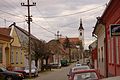
 A typical sight in Bela Crkva, Vojvodina
 -
 One of the lakes of Bela Crkva


.jpg)

See also[edit]
References[edit]
- ^ "2011 Census of Population, Households and Dwellings in the Republic of Serbia: Comparative Overview of the Number of Population in 1948, 1953, 1961, 1971, 1981, 1991, 2002 and 2011, Data by settlements" (PDF). Statistical Office of Republic Of Serbia, Belgrade. 2014. ISBN 978-86-6161-109-4. Retrieved 2014-06-27.
- ^ Apor (23 April 2014). Metamorphosis Transylvaniae. Routledge. pp. 20–. ISBN 978-1-317-85664-1.
- ^ The Illyrians-John Wilkes
- ^ István Németh - A magyarországi francia telepek
- ^ "Temes County". www.talmamedia.com. Archived from the original on March 9, 2006.
- ^ "2011 Census of Population, Households and Dwellings in the Republic of Serbia" (PDF). stat.gov.rs. Statistical Office of the Republic of Serbia. Retrieved 20 October 2017.
External links[edit]


| International | |
|---|---|
| National | |