
Todtnau
| coat of arms | Germany map | |
|---|---|---|

|
Coordinates: 47 ° 50 ' N , 7 ° 57' E |
|
| Basic data | ||
| State : | Baden-Württemberg | |
| Administrative region : | Freiburg | |
| County : | Loerrach | |
| Height : | 659 m above sea level NHN | |
| Area : | 69.59 km 2 | |
| Residents: | 4894 (Dec. 31, 2018) | |
| Population density : | 70 inhabitants per km 2 | |
| Postal code : | 79674 | |
| Area code : | 07671 | |
| License plate : | LÖ | |
| Community key : | 08 3 36 087 | |
| City structure: | 10 districts | |
City administration address : |
Rathausplatz 1 79674 Todtnau |
|
| Website : | ||
| Mayor : | Andreas Wießner | |
| Location of the city of Todtnau in the Lörrach district | ||
  |
||

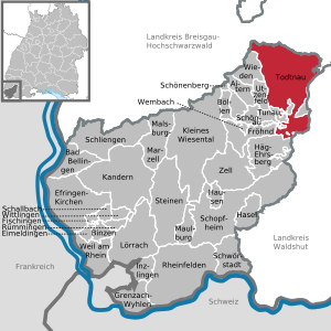
Todtnau is a town in the southern Black Forest in the district of Lörrach in Baden-Württemberg ( Germany ).
geography
Todtnau is located in the southern Black Forest between Feldberg and Belchen at an altitude of 570 to 1390 meters in the Wiesental . More than 60% of the municipal area is covered by forest.
City structure
The town of Todtnau and 25 other villages, hamlets, Zinken, farms and houses belong to the town of Todtnau, with the formerly independent communities of Aftersteg, Geschwend, Muggenbrunn, Präg , Schlechtnau and Todtnauberg , which were incorporated in the 1970s :
- Aftersteg: Village Aftersteg , Weiler Hasbach
- Geschwend: Village Geschwend , houses Gisiboden (also Dießen floor ) and Graf mat
- Muggenbrunn: village of Muggenbrunn
- Präg: Villages of Präg (Hinter- and Vorderdorf) and Herrenschwand , Hof Präger Boden and Haus Weißenbach
- Schlechtnau: Village Schlechtnau and houses Kressel
- Todtnau (within the boundaries of 1971): City of Todtnau , districts of Brandenberg and Fahl , Auf der Säge settlement , Poche hamlet , Notschrei house , and since 1973 a holiday village of the German Recreation Agency
- Todtnauberg: Dorf Todtnauberg , hamlet Ennerbach , Hangloch and Rütte , Zinken Büreten , Hof Ebenehof , houses Hornmatt and Radschert
The deserted castle is in the area of the former municipality of Präg .
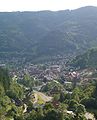
View of Todtnau

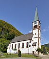
Todtnau, Church of St. John the Baptist
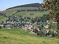
View of Todtnauberg

View from Seebuck to Brandenberg-Fahl in the upper Wiesental

Muggenbrunn, St. Cornelius Church

Schlechtnau, chapel
Geschwend, St. Wendelin Church

Aftersteg, Church of St. Anna


Population of the ten districts on January 2, 2019:
| district | population |
|---|---|
| Todtnau | 2231 |
| Todtnauberg | 713 |
| Swiftly | 393 |
| Schlechtnau | 353 |
| Brandenberg | 301 |
| After bridge | 306 |
| Coined | 253 |
| Muggenbrunn | 232 |
| Herrenschwand | 106 |
| Pale | 30th |
| City of Todtnau | 4918 |
Neighboring communities
Todtnau borders (clockwise from the north) on the municipalities:
- Oberried and Feldberg in the Breisgau-Hochschwarzwald district ,
- Sankt Blasien , Bernau and Todtmoos in the district of Waldshut ,
- Häg-Ehrsberg , Schönau in the Black Forest , Fröhnd , Utzenfeld and Wieden in the district of Lörrach and
- Münstertal in the Breisgau-Hochschwarzwald district.
history
Until the 18th century

The settlement of the area began in the 6th century by the Alemanni . Todtnau was first mentioned in a document in 1025 in a document from Emperor Konrad II. Since 1125 the place was under the jurisdiction of the Zähringer , after the family died out in 1218 the right passed to the Staufer . 1288 was the founding year as a parish . Todtnauberg was mentioned as early as 1283, which, like the Aftersteg mentioned in 1352, had emerged as a mining settlement . At that time Todtnau was the center of silver mining in the southern Black Forest and at that time belonged to the monastery of St. Blasien as a bailiwick . While the Aftersteg farming settlement consisted of three houses and barns in 1352, this year there were already ten houses around the church, 23 hermit farms and 23 ore mills in Todtnau . In the 17th century, the heyday of silver mining was already over, and by the Thirty Years War at the latest, the formerly rich miners became impoverished and were forced to make a living in agriculture .
From 1366 to 1805 Todtnau belonged to Upper Austria , after which it became Baden .
19th and 20th centuries
On July 24, 1809, Todtnau was granted city rights .
In 1876 a major fire devastated the town center with the church that was then in the valley and the so-called Oberdorf (Oberstrasse). Today's townscape with the church standing over the valley is a result of the subsequent reconstruction.
Todtnau and the surrounding area are now a popular holiday destination in the southern Black Forest. In addition, until 1967 it was the end point of the " Todtnauerli ", a narrow-gauge railway that began in Zell im Wiesental .
Incorporations
In 1939 Brandenberg-Fahl was incorporated. In the course of the municipal reform in Baden-Württemberg , the following municipalities were incorporated into Todtnau:
- April 1, 1972: Schlechtnau
- April 1, 1974: Aftersteg, Geschwend, Muggenbrunn, Präg, Todtnauberg
Coats of arms of the former municipalities

Brandenberg

Schlechtnau

After bridge

Swiftly


Herrenschwand

Muggenbrunn

Coined

Todtnauberg


politics
Municipal council
The council belong to the local elections on May 26, 2019 next to the mayor as chairman to 24 members. Due to the false choice of part of the city, there were 6 additional seats. With a turnout of 70.2% (+ 11.6), the election led to the following result:
| Parties and constituencies |
% 2019 |
Seats 2019 |
% 2014 |
Seats 2014 |
||
| CDU | Christian Democratic Union of Germany | 49.4 | 12 | 53.9 | 10 | |
| SPD | Social Democratic Party of Germany | 26.4 | 6th | 20.7 | 4th | |
| FW | Free voters | 24.2 | 6th | 25.3 | 4th | |
| total | 100.0 | 24 | 100.0 | 18th | ||
| voter turnout | 70.2% | 58.6% | ||||
mayor
In June 2015 Andreas Wießner was confirmed for a third term with 84.4%.
The following people have been mayors of Todtnau since 1809:
|
|
coat of arms
The blazon of the coat of arms reads: “In gold on a green shield base, a miner walking to the left in a silver-adorned costume with a black cap, a shouldered black mallet in his right hand, a black torch with a red flame in his left; on the arms, held by silver straps, on the right a black bag, on the left two black irons. “The miner with a mallet is already depicted on the Todtnau seals between 1341 and 1699. In 1902, the General State Archives in Karlsruhe designed the coat of arms, which was continued with changes in the color and shape of the shield. The coat of arms in its current form was awarded to the city in 1972 by the Baden-Württemberg Ministry of the Interior.
The description of the coat of arms is an indication of the historical importance of silver mining in the area around the city. The coats of arms of incorporated communities also show elements that refer to mining (Aftersteg, Brandenberg, Todtnauberg).
Culture and sights

nature
Between Todtnau and Aftersteg there are the Todtnau waterfalls , in which the Stübenbach falls 97 meters. They can be reached from the parking lots at Todtnauberg and Aftersteg. In the upper valley head of the Wiesental you can find the Fahler waterfalls with a total height of around 40 meters. Large parts of the urban area of Todtnau are occupied by the two largest nature reserves in Baden-Württemberg, the Feldberg nature and landscape reserve and the Präg glacier basin .
On a historical tour through Todtnau-Muggenbrunn you have the opportunity to take a historical journey. Those interested can get to know the village and its past on a total of 21 information boards along the way. The nature of the place and a view over Muggenbrunn are just as much a part of this hike as a visit to the oldest house in the village.
In March 2019, in the Geschwend district, a 5.5-ton boulder almost fell from a height of 800 meters on a house at the foot of the mountain. Seven months later, on October 23, Todtnau's mayor Andreas Wießner had 15 houses evacuated. The St. Wendelin Church is also not allowed to be entered. A few weeks later, six of the houses were allowed to be inhabited again. The slope is now being secured with anchors and steel nets.
Sports
On the south-east of the Hasenhorn there is a mountain bike downhill route and a 3500 m long toboggan run prepared in winter, as well as a 2900 m long all-weather toboggan run (summer and winter operation). The train overcomes a height difference of 385 meters.
In the Black Forest barracks in Todtnau-Fahl there is a sports promotion group of the Bundeswehr .
The first German ski club was founded in Todtnau in 1891, the Todtnau ski club in 1891 .
In Todtnauberg there are five drag lifts and a conveyor belt with a slope length of 13 kilometers. Every Wednesday to Friday there is floodlight rides from 5 p.m. These lifts can be used free of charge with the Hochschwarzwald-Card , as they are part of the Feldberg lift network .
The Nordic Center Notschrei, also located in Todtnau, with its Nordic Arena is a DSV federal base for Nordic skiing / biathlon and a contact point for national and regional squad athletes as well as for association squads and clubs. The German Disabled Sports Association (DBS) and international training groups also use the facility. The arena is the only competitive location for biathlon in Baden-Württemberg , so that national and international competitions can be held here. The Nordic Center Notschrei also includes the adjoining cross-country ski center and a Nordic school.
At Easter 1980, a team from Todtnau was able to prevail in the German qualification of Games Without Borders against Walldorf , Bellheim , Bad Wurzach and the host Bruchsal and qualify for the international game on May 27, 1980 in Vilamoura , Portugal . Todtnau was also able to win the competition here, this time against seven European cities. With this victory they were able to take part in the final grand finale in Namur , Belgium , on September 10th , where they finished fourth.
Regular events
The Städlifest has been held annually since 1975 . At this city festival , Todtnauer associations operate stalls for various specialties and festival tents . Part of the profit generated goes to charities that change every year .
Since 2002 , a “Philosophical Autumn” has been organized in Todtnauberg, where Martin Heidegger spent a lot of time in his hut, the theme of which is inspired by the work of the philosopher. The Todtnauberg Literature Days have also been held in Todtnauberg since 2005 under the motto “Reading on the Mountain” in November and December, a platform for encounters with authors from Upper Rhine. In addition, the Black Forest Cake Festival has been taking place every two years since 2006 , at which amateurs and professionals compete with their Black Forest cakes . In 2020 the event was postponed to the following year due to the COVID-19 pandemic .
Economy and Infrastructure
traffic
The federal road 317 ( Weil am Rhein - Feldbergpass - Titisee-Neustadt ) connects Todtnau to the national road network . There is also a road connection to the Freiburg area on Landesstraße 126 via the Notschrei to Kirchzarten in the Dreisamtal and from Notschrei also via the Schauinsland directly to Freiburg (L 124). The station Todtnau was due to the now-defunct railroad Zell im Wiesental-Todtnau . Via Geschwend you can reach the Weißenbachsattel and the municipality of Todtmoos in the neighboring district of Waldshut .
Established businesses
The largest industrial companies and employers are the textile works Todtnau Bernauer KG as well as the companies Zahoransky Group (the world's largest manufacturer of machines for brush production), Ebser (also traditional manufacturer of brush machines) and the brush manufacturers Faller, Huber, Keller, Knotz and Sättele. Some of the locally based companies have been trying to improve the economic and social infrastructure of the Upper Wiesental since 2002 as the Upper Wiesental Initiative Group (IOW) .
Personalities
sons and daughters of the town
- Johannes Kreuz (* in the 14th century), abbot in the monastery of St. Blasien
- Petrus Bösch (* in the 15th century), abbot in the monastery of St. Blasien
- Blasius Bernauer (1740–1818), organ builder
- Karl Ludwig Nessler (1872–1951), hairdresser and inventor of the perm , who has also been honored by a Nessler Museum in Todtnau since October 2006, set up as an Art Nouveau hairdressing salon.
- Eduard Lais (1893–1974), born in Präg, economist and politician (BCSV, CDU), member of the state parliament, Baden's Minister of Economic Affairs
- Karl Vetter (1895 - unknown), politician (NSDAP)
- Erwin Mühlhaupt (1905–1975) Protestant theologian, professor for church history at the Kirchl. University in Wuppertal
Other personalities
- Martin Heidegger (1889–1976), philosopher; had in 1922 a hut in Todtnauberg, where he spent a lot of time, some of his books authored and guests such as the physicist Werner Heisenberg , the poet Paul Celan , the mirror -Herausgeber Rudolf Augstein and the philosopher Hermann Mörchen and Hans-Georg Gadamer visited has been.
See also
literature
- Theodor Humpert : Todtnau. The essence and development of a Black Forest town , 2nd edition, 1959
- Albrecht Schlageter et al. (Authors), City of Todtnau (Editor): Todtnau. City and holiday region in the southern Black Forest , Freiburg 1989 ISBN 3-7930-0115-6
- Todtnau. In: Department State Description of the State Archives Freiburg im Breisgau (editor): District descriptions of the State of Baden-Württemberg. The district of Loerrach. Volume II. B. Community descriptions Kandern to Zell im Wiesental. Published by the Baden-Württemberg State Archives Directorate in conjunction with the Lörrach district. Jan Thorbecke Verlag, Sigmaringen 1994, ISBN 3-7995-1354-X . Pp. 661-721
Web links
- Official homepage of the city of Todtnau
- Regional information system for Baden-Württemberg (LeoBW): Todtnau - archive material
Individual evidence
- ↑ State Statistical Office Baden-Württemberg - Population by nationality and gender on December 31, 2018 (CSV file) ( help on this ).
- ↑ http://www.todtnau.de/buergerservice/statistiken/einwohner.htm
- ^ Regional information system for Baden-Württemberg (LeoBW): Aftersteg - Altgemeinde ~ sub-town - Historical local dictionary Baden-Württemberg
- ^ Regional information system for Baden-Württemberg (LeoBW): Geschwend - Altgemeinde ~ sub-town - historical local dictionary Baden-Württemberg
- ^ Regional information system for Baden-Württemberg (LeoBW): Muggenbrunn - Altgemeinde ~ sub-town - Historical local lexicon of Baden-Württemberg
- ^ Regional information system for Baden-Württemberg (LeoBW): Schlechtnau - Altgemeinde ~ sub-town - Historical local lexicon of Baden-Württemberg
- ^ Regional information system for Baden-Württemberg (LeoBW): Todtnau - Altgemeinde ~ sub-town - Historical local dictionary Baden-Württemberg
- ^ Regional information system for Baden-Württemberg (LeoBW): Brandenberg - Wohnplatz - Historical Ortlexikon Baden-Württemberg
- ^ Regional information system for Baden-Württemberg (LeoBW): Fahl - Wohnplatz - Historisches Ortlexikon Baden-Württemberg
- ↑ Todtnau. In: Department State Description of the State Archives Freiburg im Breisgau (editor): District descriptions of the State of Baden-Württemberg. The district of Loerrach. Volume II. B. Community descriptions Kandern to Zell im Wiesental. Published by the Baden-Württemberg State Archives Directorate in conjunction with the Lörrach district. Jan Thorbecke Verlag, Sigmaringen 1994, ISBN 3-7995-1354-X . P. 669
- ^ The state of Baden-Württemberg. Official description by district and municipality. Volume VI: Freiburg region Kohlhammer, Stuttgart 1982, ISBN 3-17-007174-2 . Pp. 901-906
- ↑ Population statistics 2019 on the website of the city of Todtnau , accessed on March 17, 2019.
- ^ Federal Statistical Office (ed.): Historical municipality directory for the Federal Republic of Germany. Name, border and key number changes in municipalities, counties and administrative districts from May 27, 1970 to December 31, 1982 . W. Kohlhammer, Stuttgart / Mainz 1983, ISBN 3-17-003263-1 , p. 498 .
- ^ Federal Statistical Office (ed.): Historical municipality directory for the Federal Republic of Germany. Name, border and key number changes in municipalities, counties and administrative districts from May 27, 1970 to December 31, 1982 . W. Kohlhammer, Stuttgart / Mainz 1983, ISBN 3-17-003263-1 , p. 521 .
- ^ André Hönig: There are 24 instead of 18 seats in the Todtnau municipal council. In: Badische Zeitung of May 28, 2019; accessed on January 17, 2020
- ^ Hermann Jacob: Todtnau: Andreas Wießner confirmed in office. In: Badische Zeitung of June 29, 2015; accessed on January 17, 2020
- ^ City of Todtnau (editor): Todtnau. City and holiday region in the southern Black Forest , Freiburg 1989, p. 358
- ↑ Ulrike Jäger: Much advanced. In: Badische Zeitung of May 11, 2011, accessed on January 17, 2020
- ↑ Harald Huber: Wappenbuch Landkreis Lörrach . Südkurier GmbH, Konstanz 1984, ISBN 3-87799-046-0 . P. 121
- ↑ Todtnau Muggenbrunn - historical tour. Retrieved January 25, 2019 .
- ↑ Frank Zimmermann: In Todtnau-Geschwend there is fear of stone avalanches. Badische Zeitung, November 16, 2019, accessed on December 8, 2019 .
- ↑ Martin Klabund: This is how the rocks in Geschwend are secured from falling. Badische Zeitung, December 4, 2019, accessed on December 8, 2019 .
- ↑ Internet presence of the Hasenhorn toboggan run , accessed on November 22, 2012.
- ↑ Homepage of the association
- ↑ Stilecht design agency: Todtnauberg ski lifts. Retrieved October 9, 2017 .
- ↑ Nordic Center Notschrei. Black Forest Nordic Center Notschrei e. V., accessed January 25, 2019 .
- Jump up ↑ Games without Frontiers, whole broadcast from May 27, 1980 with English commentary
- ↑ Cherry Pie Festival. bergwelt-suedschwarzwald.de, archived from the original on July 3, 2012 ; accessed on May 3, 2020 .
- ↑ http://www.mopo.de/news/gesellschaft-museum-ueber-wellewellen-erfinder-karl-nessler-eroeffnet,5066732,5744870.html
Aftersteg | Geschwend | Muggenbrunn | Coined with the district of Herrenschwand | Schlechtnau | Todtnauberg

Aitern | Bad Bellingen | Binzen | Böllen | Efringen churches | Eimeldingen | Fischingen | Happy | Grenzach-Wyhlen | Häg-Ehrsberg | Hazel | Hausen im Wiesental | Inzlingen | Kandern | Small meadow valley | Loerrach | Malsburg-Marzell | Maulburg | Rheinfelden | Rümmingen | Schallbach | Schliengen | Schönau in the Black Forest | Schönenberg | Schopfheim | Schwörstadt | Stones | Todtnau | Tunau | Utzenfeld | Because on the Rhine | Wembach | Wieden | Whiting | Zell im Wiesental