Berles-au-Bois
| Berles-au-Bois | ||
|---|---|---|

|
|
|
| region | Hauts-de-France | |
| Department | Pas-de-Calais | |
| Arrondissement | Arras | |
| Canton | Avesnes-le-Comte | |
| Community association | Campagnes de l'Artois | |
| Coordinates | 50 ° 12 ′ N , 2 ° 38 ′ E | |
| height | 105-159 m | |
| surface | 8.9 km 2 | |
| Residents | 515 (January 1, 2017) | |
| Population density | 58 inhabitants / km 2 | |
| Post Code | 62123 | |
| INSEE code | 62112 | |
| Website | http://www.berlesaubois.fr/ | |
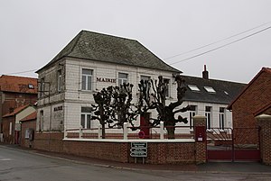
 Town hall (Mairie) of Berles-au-Bois |
||
Berles-au-Bois is a French commune with 515 inhabitants (at January 1, 2017) in the department of Pas-de-Calais in the region of Hauts-de-France . It belongs to the Arrondissement of Arras and the canton of Avesnes-le-Comte (until 2015 canton of Beaumetz-lès-Loges ).
Neighboring communities of Berles-au-Bois are Bailleulmont in the north-west, Bailleulval in the north, Rivière in the north-east, Ransart in the east, Pommier in the south-east, Bienvillers-au-Bois in the west and Monchy-au-Bois in the south-west.
Population development
| year | 1962 | 1968 | 1975 | 1982 | 1990 | 1999 | 2007 |
| Residents | 582 | 557 | 524 | 531 | 524 | 484 | 499 |
Attractions
- St. Pierre Church
Web links
Commons : Berles-au-Bois - collection of images, videos and audio files
