
Quœux-Haut-Maînil
| Quœux-Haut-Maînil | ||
|---|---|---|

|
|
|
| region | Hauts-de-France | |
| Department | Pas-de-Calais | |
| Arrondissement | Arras | |
| Canton | Auxi-le-Château | |
| Community association | Ternois | |
| Coordinates | 50 ° 18 ′ N , 2 ° 7 ′ E | |
| height | 77-139 m | |
| surface | 12.01 km 2 | |
| Residents | 257 (January 1, 2017) | |
| Population density | 21 inhabitants / km 2 | |
| Post Code | 62390 | |
| INSEE code | 62683 | |
 Saint-Jacques church |
||

Quœux-Haut-Maînil is a French municipality with 257 inhabitants (at January 1, 2017) in the department of Pas-de-Calais in the region of Hauts-de-France (2015 Nord-Pas-de-Calais ). It belongs to the Arrondissement of Arras and the Ternois Association of Municipalities .
geography
The northern French community of Quœux-Haut-Maînil is located in the southwest of the historic Ternois landscape , about 30 kilometers northeast of Abbeville and 50 kilometers west of Arras . The municipality covers a section of the elongated plateau between the river valleys of Authie and Canche , which are aligned almost parallel to the northwest to the English Channel . Characteristic for Quœux-Haut-Maînil and the surrounding area are wide arable and pasture areas, interrupted by long rows of trees protecting from the wind, as well as the lack of larger forest areas. The soils are very calcareous, so that precipitation seeps away quickly. At the edge of the plateau, some dry valleys have cut into the relief ( Fond des Six Pierres, Fond de Vieil-Hesdin, Fond des Carrières ).
The municipality consists of the settlements Quœux and Haut-Maînil and the hamlet of Montorgueil .
Neighboring municipalities of Quœux-Haut-Maînil are Wail in the north, Galametz and Fillièvres in the northeast, Haravesnes in the southeast, Vaulx in the south, Gennes-Ivergny in the southwest, Fontaine-l'Étalon in the west and Vacqueriette-Erquières in the northwest.
history
The municipality was created in 1972 with the merger of Quœux and Haut-Maînil . In 1346, the Battle of Crécy took place in the vicinity of today's municipality .
Population development
| year | 1962 | 1968 | 1975 | 1982 | 1990 | 1999 | 2007 | 2017 | |
| Residents | 219 | 185 | 309 | 328 | 273 | 262 | 240 | 257 | |
| Sources: Cassini and INSEE | |||||||||
Attractions
The church of Saint-Jacques was rebuilt in 1774 while retaining the tower from the 15th century with a carved confessional from the 18th century. The church of Saint-Thomas in the Haut-Maînil district was also built in 1774.
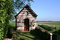
Jesus-Flagellé Chapel

Fallen memorial

.JPG)
Economy and Infrastructure
Quœux-Haut-Maînil has retained its village character. Agriculture, especially sheep farming, plays an important role. In the community there are still 15 main-income farms.
Road connections exist to the nearby municipalities of Haravesnes, Fillièvres, Fontaine-l'Etalon, Vacqueriette-Erquières and Auxi-le-Château . In the city of Hesdin , eleven kilometers away , the highways Saint-Omer - Abbeville and Arras - Berck cross .
supporting documents
- ↑ Quœux-Haut-Maînil on cassini.ehess.fr
- ↑ Quœux-Haut-Maînil on insee.fr
- ↑ Entry on patrimoine-de-france.org ( memento of April 24, 2008 in the Internet Archive ) (French)
- ↑ Description on ccauxilois.free.fr/34 (French)