Arleux-en-Gohelle
| Arleux-en-Gohelle | ||
|---|---|---|

|
|
|
| region | Hauts-de-France | |
| Department | Pas-de-Calais | |
| Arrondissement | Arras | |
| Canton | Brebières | |
| Community association | Osartis Marquion | |
| Coordinates | 50 ° 22 ′ N , 2 ° 52 ′ E | |
| height | 50-75 m | |
| surface | 6.27 km 2 | |
| Residents | 856 (January 1, 2017) | |
| Population density | 137 inhabitants / km 2 | |
| Post Code | 62580 | |
| INSEE code | 62039 | |
| Website | http://www.arleuxengohelle.fr/ | |
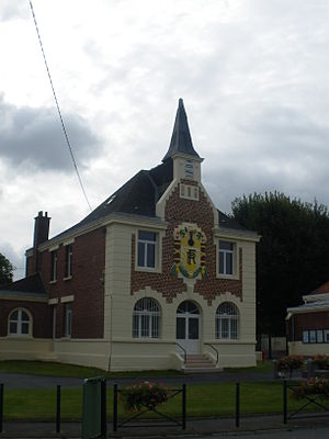
 Town hall (Mairie) of Arleux-en-Gohelle |
||
Arleux-en-Gohelle is a French commune in Arrondissement Arras in the department of Pas-de-Calais in the region of Hauts-de-France . The municipality belongs to Arras-2 (until 2015: Canton Vimy ). It has 856 inhabitants (as of January 1, 2017).
geography
Arleux-en-Gohelle is located about nine kilometers north-northeast of Arras . Arleux-en-Gohelle is surrounded by the neighboring municipalities of Méricourt in the north, Acheville in the northeast, Fresnoy-en-Gohelle in the east, Oppy in the southeast, Bailleul-Sir-Berthoult in the south and southwest, Willerval in the west and Vimy in the northwest.
history
The place was first mentioned as Haluth in 1119 . During the First World War , Arleux-en-Gohelle was completely destroyed. After the war the place was completely reconstructed.
| Population development | ||||||||
|---|---|---|---|---|---|---|---|---|
| year | 1962 | 1968 | 1975 | 1982 | 1990 | 1999 | 2006 | 2013 |
| Residents | 564 | 575 | 557 | 509 | 675 | 709 | 814 | 835 |
| Source: Cassini and INSEE | ||||||||
Attractions
- Saint Martin Church
- Notre-Dame chapel in Tongre
- Canadian Military Cemetery

