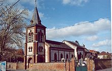
Anzin-Saint-Aubin
| Anzin-Saint-Aubin | ||
|---|---|---|

|
|
|
| region | Hauts-de-France | |
| Department | Pas-de-Calais | |
| Arrondissement | Arras | |
| Canton | Arras-1 | |
| Community association | Arras | |
| Coordinates | 50 ° 19 ′ N , 2 ° 45 ′ E | |
| height | 56-94 m | |
| surface | 5.13 km 2 | |
| Residents | 2,742 (January 1, 2017) | |
| Population density | 535 inhabitants / km 2 | |
| Post Code | 62223 | |
| INSEE code | 62037 | |
| Website | http://www.ville-anzin-saint-aubin.fr/ | |
Anzin-Saint-Aubin is a French commune with 2,742 inhabitants (as of January 1 2017) in the department of Pas-de-Calais in the region of Hauts-de-France . It belongs to the Arrondissement of Arras and the Canton of Arras-1 . The inhabitants are called Anzinois .
geography
Anzin-Saint-Aubin is on the Scarpe . Anzin-Saint-Aubin is surrounded by the neighboring communities of Neuville-Saint-Vaast in the north, Sainte-Catherine in the east, Arras in the south, Duisans in the south-west and Marœuil in the north-west.
The Route nationale 25 runs through the municipality .
history
The village of Anzin is first mentioned as Anzinum around 866 , while Saint-Aubin appears as a church place in 1154. In 1790 the community was formed under the name Commune-des-Frères-Unis (German: community of united brothers), which again took the name of its two localities after the revolutionary years.
| year | 1962 | 1968 | 1975 | 1982 | 1990 | 1999 | 2006 | 2011 |
|---|---|---|---|---|---|---|---|---|
| Residents | 960 | 1,052 | 1,278 | 1,726 | 2,543 | 2,470 | 2,655 | 2,651 |
Attractions
- Sacré-Cœur Church
- Saint-Aubin Chapel
- Castle from the 18th century, today's town hall
- British military cemetery
- Remains of the medieval water mill
Personalities
- Maxime Colin (born 1991), football player

